Basin-centered gas systems: evaluation and exploration strategies
| Basin-centered gas systems | |
| |
| Series | AAPG Bulletin, November 2002 |
|---|---|
| Author | Ben E. Law |
| Link | Web page |
Formation evaluation[edit]
All basin-centered gas accumulations (BCGAs) reservoirs require carefully designed drilling programs and some type of artificial stimulation for commercial production rates. Reservoir continuity is an important consideration in the design of an appropriate drilling and completion program. Single, lenticular reservoirs have limited volume and are generally not commercial, whereas single, blanket reservoirs have much larger volumes and may be commercial, but, because blanket reservoirs commonly have better reservoir quality than lenticular reservoirs, they may be water bearing, as discussed previously.
In lenticular, fluvial-dominated reservoirs, such as those in the Jonah field in the northern part of the Green River basin of Wyoming or the Rulison field in the Piceance basin of Colorado, it is imperative to stimulate as many reservoirs as possible to attain commercial rates of gas production. The completion practices in the Jonah field provide a good example of commingling production from multiple, lenticular reservoirs;[1] [2] as many as 28 sandstones are perforated and fractured.[3] In a similar manner, gas production from multiple sandstone reservoirs in the Upper Cretaceous Williams Fork Formation in the Piceance basin of western Colorado is commingled following multiple fracture treatments in an interval about 2400 ft (732 m) thick (R. E. Mueller, 2002, personal communication).
Early attempts to produce from blanket reservoirs were mixed. Massive hydraulic fracturing techniques using 300,000 lb of proppant were used in an attempt to create long fractures. However, the large fracture treatments commonly resulted in shorter fracture lengths than predicted because of fracturing out of the reservoir into adjacent, nonreservoir rocks.[4] This problem has, in some cases, been modified by adjusting pumping rates of the fracture fluids.
Natural fractures are important factors in successfully completing a well. The probability of a vertically drilled hole intersecting fractures is considerably less than horizontal or slant holes. For example, at the U.S. Department of Energy Multiwell Experiment site in the Piceance basin of Colorado, a slant hole was drilled through lenticular gas reservoirs. The hole was then deviated to horizontal in a blanket reservoir. Fifty-two fractures were reported from 266 ft (81 m) of core taken from the slant hole part of the hole. In contrast, a nearby vertically drilled hole penetrating the same slant hole interval encountered one fracture, and, in the horizontally drilled part of the hole, 37 fractures were reported from 115 ft (35 m) of core.[5] In a more recently drilled 14,950 ft (4557 m)-deep well in the Green River basin of Wyoming, more than 400 open fractures were detected on a Formation MicroImager log from a 1750 ft (533 m)-long horizontally drilled leg in the Upper Cretaceous Frontier Formation.[6] In the same well, approximately 76 natural fractures were recorded from a 78.2 ft (23.8 m)-long core taken from the same horizontal leg.[7] From these two examples, the probability of encountering fractures in slant or horizontal wells vs. vertically drilled wells is well documented. The cost of drilling nonvertical wells, however, is considerably greater than the cost of drilling vertical wells.
Reservoir damage is another important aspect of formation evaluation. Spencer[8] listed several different types of reservoir damage, including (1) movement of secondary clays causing plugging of pore throats, (2) swelling of smectitic clays, (3) increasing water saturation with consequent reduction of relative permeability to gas, (4) fracturing gel compounds left in the reservoir, and (5) chemical additives causing precipitation of minerals and compounds during acidizing and hydraulic fracturing. The potential problem of swelling clays, in most cases, is minor, because most BCGAs occur in sequences where the level of thermal maturation is sufficiently high to convert swelling clays into nonswelling clays.
Exploration strategy[edit]
The objective of any hydrocarbon exploration program is to progress from coarse, loosely defined ideas to refined, drillable locations. In the case of BCGAs, exploration strategies are no different and may be viewed as a four-step process that includes (1) reconnaissance, (2) confirmation, (3) delineation, and (4) sweet spot identification. The exploration phases are mostly applicable to direct BCGAs; as a consequence of the relatively new classification of BCGAs into direct and indirect types, strategies for indirect BCGAs have not been formulated, although it is obvious that source rock considerations, level of thermal maturation, and temporal relationships among hydrocarbon generation, expulsion, migration, and trap formation are very important considerations in the exploration for indirect BCGAs.
Reconnaissance phase[edit]
The reconnaissance phase entails the identification of basins that may contain BCGAs. In direct systems, identification of source rocks is critical. For example, the identification of humic, gas-prone coal beds is the most obvious source rock for direct BCGAs; in nearly every country with coal reserves, there are some published data concerning geographic distribution, rank, and thickness. The rank of coal beds must be greater than high-volatile C (greater than vitrinite reflectance values of 0.6% Ro) to initiate thermal generation of gas.[9]
The existence of reservoirs with appropriate quality is another important aspect to consider during the reconnaissance phase. In most cases, coal-bearing intervals are associated with interbedded sandstones that have low porosity and permeability, especially at diagenetic stages commensurate with thermal maturity levels greater than 0.6% Ro. Sandstones deposited in alluvial plain, coal-bearing environments typically have poor reservoir properties. High porosity and permeability in reservoirs are not desirable attributes for the development of a BCGA. In basins where some drilling activity has occurred, gas shows are also very helpful.
Confirmation phase[edit]
Once a basin containing a potential BCGA has been identified, the task becomes one of confirmation. Because all BCGAs are abnormally pressured, the principal task during this phase is the determination of reservoir pressure and the mechanism of abnormal pressure. Most basins do not have sufficient quantity or quality of pressure data for this determination. Therefore, a combination of attributes listed on Table 1 can provide compelling evidence for the presence of abnormal pressure and a BCGA. Pore pressure indicators such as pore fluid composition (gas with little or no producible water) in conjunction with porosity (<13%), permeability (<0.1 md), thermal maturation (>0.7% Ro) data, and sustained gas shows are very useful. In some cases, sonic velocity data have been used to indicate the presence of abnormal pressures.[10] [11] [12] [13]
| Type | Source rocks | Reservoir in-situ permeability (md) | Hydrocarbon migration distance | Reservoir pressure | Pressure mechanism | Seal | Seal quality | Nature of upper boundary | Thermal maturity top of BCGA | Occurrence |
|---|---|---|---|---|---|---|---|---|---|---|
| Direct | gas-prone type III kerogen | <0.1 | short | over-/underpressure | hydrocarbon generation | capillary | variable | cuts across stratigraphy | >0.7% Ro | downdip from water |
| Indirect | liquid-prone types I/II kerogen | <0.1 | short/long | over-/underpressure | thermal cracking of oil to gas | lithologic/capillary | good | bedding parallel | highly variable | downdip from water |
Although the determination of abnormal pressure is important, it is equally important to determine the mechanism of abnormal pressure. For direct BCGAs, the pressure mechanism is hydrocarbon generation,[14] and for indirect BCGAs, the pressure mechanism is thermal cracking of liquid hydrocarbons to gas.[15] A useful criteria for determining the pressure mechanism is through a knowledge of the composition of pore fluids: pore fluids in direct and indirect systems are composed of gas with little or no producible water,[14] [16] whereas in abnormally pressured reservoirs, where the composition of pore fluid is mainly water, the pressure mechanism may be one of several other mechanisms, thereby precluding a hydrocarbon-generation mechanism and presence of a BCGA.
Formation resistivity and spontaneous potential curves measured on geophysical well logs also have been used to indicate the presence of a BCGA. In Upper Cretaceous rocks in the San Juan basin and Mesozoic rocks in the Alberta basin, resistivities greater than 20 Ω were reported to be gas saturated.[17] Zagorski[18] [19] noted that the boundary between conventional and BCGA reservoirs in northwestern Pennsylvania could be distinguished at 80 Ω; reservoirs with high water saturation were defined by resistivities <80 Ω•m, and reservoirs within the BCGA have resistivities >80 Ω•m. In Upper Cretaceous rocks in the Greater Green River basin, spontaneous potential curves are commonly reversed in abnormally pressured BCGAs.[20] [21] [22]
Delineation[edit]
The delineation phase entails mapping the vertical and areal distribution of the gas accumulation. The preferred way of accomplishing this phase is through the use of reliable pressure data. In most basins, however, pressure data are absent or of such low quality that reliable maps cannot be constructed; consequently, some indirect method may have to be used. The selected mapping parameter should be one that has been calibrated to well-documented pressure data. For example, thermal maturity values ranging from 0.7 to 0.9% Ro were determined to be coincident with the top of overpressuring in the Greater Green River basin.[22] In later work, 0.8% Ro was used to map the depth to the top of overpressuring in the basin.[23] [24] Johnson et al.[25] [26] [27] used a value of 0.73% Ro to map the top of the gas- and water-bearing transition zone above gas-saturated reservoirs in the Piceance basin of Colorado and the Wind River and Bighorn basins of Wyoming.
To determine an accurate, reliable mapping method, a detailed study of a small area within the basin is recommended rather than a broad-based regional study. For the detailed study, a small representative area with relatively complete, high-quality data should be chosen. Comprehensive, multidiscipline investigations including stratigraphic, structural, source rock, reservoir rock, pressure, thermal history, petrophysical, and well log analyses should then be conducted within the selected area. The objective of this comprehensive investigation is to establish a type area or analog for the entire basin to which incomplete or fragmentary data from other parts of the basin can be compared. From such analog studies, indirect mapping tools, such as levels of thermal maturity, present-day temperature, and log responses, may be determined. Examples of such analog studies include the Pacific Creek area in the Greater Green River basin,[20] [21] the Wagon Wheel well in the Greater Green River basin,[28] and the Multiwell Experiment site in the Piceance basin, Colorado.[29] [30] [28] Regional mapping using some of these indirect parameters can then be used not only to determine the stratigraphic and areal distribution of the BCGA but also to help identify areas of enhanced reservoir quality, or sweet spots.
Sweet spot identification[edit]
Although a few BCGAs are commercially productive over their entire areal extent, such as the San Juan basin of Colorado and New Mexico, most BCGAs are not commercially productive over their entire area. Consequently, areas within the BCGA of enhanced reservoir quality (sweet spots) must be identified. These sweet spots may be structural or stratigraphic in nature and always occur within the abnormal pressure envelope. In addition, they most likely occur near the upper boundary of the BCGA.
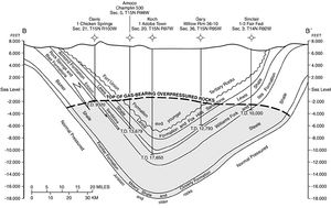
In Figure 1, the top of overpressure and BCGA in the Washakie basin is shown as a fairly smooth, uniform line cutting across structural and stratigraphic boundaries. In this case, if very closely spaced pressure data were available along the line of section, the pressure boundary would most likely not be as smooth as shown but would probably be highly irregular, with significant areas of high relief. The areas of high, positive relief, or bumps, may be indicative of structural and/or stratigraphic sweet spots that occur at or near the upper boundary of the BCGA. In the absence of closely spaced pressure data, it is difficult to identify a sweet spot. However, some techniques can be used to identify and focus more expensive techniques such as three-dimensional (3-D) seismic surveys. Those techniques may include lineament, thermal maturity, and present-day temperature mapping. Aeromagnetic, gravity, and surface geochemical surveys also may be useful in the identification of potential sweet spots. Surdam[10] and Surdam et al.[11] described methods employing sonic logs to identify sweet spots in several basins in Wyoming.
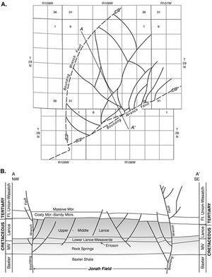
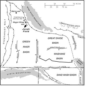
The best example of a BCGA structural sweet spot is the Jonah field in the northern part of the Green River basin, Wyoming (Figure 2, Figure 3). As previously discussed, the Jonah field is a gas chimney, rooted in a regionally pervasive BCGA described by Law (1984) and producing from multiple sandstone reservoirs in the Upper Cretaceous Lance Formation. Alternatively, Cluff and Cluff[32] have interpreted the Jonah field to be a remnant of a larger, much more shallow BCGA than presently identified. The Jonah field is a wedge-shaped area with the north, south, and west boundaries of the field defined by westward converging faults (Figure 3). The eastern boundary is undefined. The geologic characteristics of the Jonah field are given by Montgomery and Robinson[3] and Warner.[31] [33] According to Warner[33] the top of overpressure (top of gas-saturated reservoirs) within the field occurs at depths of 7700 ft (2347 m) at the west end of the field (updip end of field) and 9500 ft (2896 m) at the east end of the field (downdip end of the field). Outside the field, the top of overpressure and gas-saturated reservoirs occur at depths ranging from 11,200 to 11,600 ft (3414-3536 m).[33] Thus, there is 2500-3000 ft (726-914 m) of relief on the top of overpressuring from outside the field to inside the field (Figure 3). The gas chimney has subsequently been identified through the use of sonic velocity data.[13]
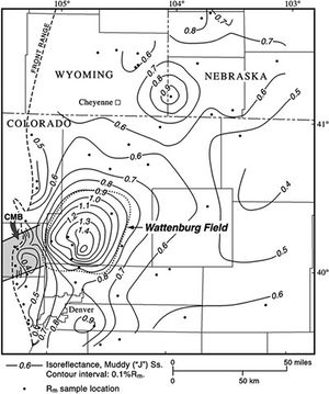
A good example of a thermal maturity anomaly associated with a sweet spot is the Lower Cretaceous Muddy ("J") Sandstone in the Denver basin of Colorado. Regional thermal maturity mapping in the Denver basin of Colorado[34] shows the presence of an anomaly associated with a BCGA (Figure 4). The anomaly, defined by reflectance values greater than 0.9% Ro (for better understanding of reflectance values correlation you can look at thetermpapers.net), is nearly coincident with the field boundaries of production from the Muddy Sandstone in the Wattenburg field. The anomaly is located north of the structurally deepest part of the basin and is coincident with the northeast projection of the Colorado Mineral Belt. The field is also coincident with a temperature anomaly mapped by Meyer and McGee.[35]
Because the top of a BCGA is determined, in part, by permeability variations and the ease with which gas may move through reservoirs, measured levels of thermal maturity at the top of a BCGA may provide indirect evidence of the presence of a sweet spot; relatively low values of thermal maturity (<0.8% Ro) at the top of an overpressured BCGA are indicative of a potential sweet spot, whereas relatively high values of thermal maturity (>0.8% Ro) are indicative of very low permeability in an overpressured BCGA. Based on vitrinite reflectance profiles from two wells within the Jonah field,[31] the level of thermal maturity at the top of overpressured, gas-saturated reservoirs is less than 0.7% Ro, compared to 0.8% Ro outside the field. Thermal maturity indices, however, cannot be used to identify potential sweet spots in underpressured BCGAs. The level of thermal maturity at the top of an underpressured BCGA most likely is higher than the level of thermal maturity at the top of an overpressured BCGA because the dimensions, or size, of a BCGA are reduced during the transition from overpressure to underpressure. Consequently, the level of thermal maturity at the top of an underpressured BCGA reflects that size constriction.
Stratigraphic sweet spots are more difficult to discern than structural sweet spots because detailed facies mapping requires close-spaced to moderately spaced subsurface data. An example of a stratigraphic sweet spot includes the Upper Cretaceous Almond Formation in the Washakie basin of southwest Wyoming, where reservoirs in the upper, marginal marine part of the formation are typically much more productive than reservoirs in the lower, fluvial-dominated part of the formation. Additional stratigraphic sweet spots include sandstones within the Upper Cretaceous Lewis Shale in the Great Divide basin and the Frontier Formation along the structural crest of the Moxa arch in the Green River basin.
Finally, based on empirical observations, there appears to be a relationship between producibility and the nature of abnormal pressure; overpressured BCGA reservoirs generally require the identification of sweet spots for commercial production, whereas underpressured reservoirs are regionally productive and do not require the identification of sweet spots. The best examples of regionally productive gas production from underpressured systems occur in Upper Cretaceous reservoirs in the San Juan basin of New Mexico and Colorado and in the Lower Silurian Clinton-Medina reservoirs in the Appalachian basin of Pennsylvania. However, sweet spots, even in underpressured BCGAs, are desirable features to identify. The reasons for this apparent relationship between producibility and the nature of abnormal pressure are uncertain. Perhaps reservoir quality is slightly improved during the transition from an overpressured system to a underpressured system.
Outlook[edit]
In 1978 the Natural Gas Policy Act provided incentive prices and, later, tax credits for gas production from coal, shale, and low-permeability sandstone reservoirs in an attempt to stimulate the development of gas from unconventional, marginally economic reservoirs. Those incentives, along with significant funding from the U.S. Department of Energy for research and development of tight gas sands, were instrumental in unlocking a gas supply that has had and will have a significant impact on the energy needs of the United States and the world. At the end of 1992 the incentives expired, and there was some skepticism in the industry concerning continued gas production without some economic help. However, new technological gains, an improved geologic and engineering understanding of tight gas sands, and higher gas prices have combined to make BCGAs (tight gas sands) a very attractive exploration objective. In the United States and Canada, exploration and exploitation of this huge gas resource has experienced considerable success, and activity should accelerate over the next several years. Internationally, exploration activity is currently minimal but likely will increase in the near future. As the concepts of BCGSs become better known outside North America, there will be an increased focus on the tremendous potential of this gas resource.
Research recommendations[edit]
As previously discussed, gas production from BCGAs is currently making a significant contribution to the energy needs of the United States, and the future role of BCGSs will be significant; however, some large obstacles must be addressed for this type of unconventional gas system to meet or surpass expectations. In order for BCGAs to play an increasing role in the energy requirements of the United States and the world, the following topics and problems need to be addressed:
- An effective global education program is essential to stimulate and expand exploration programs beyond the United States and Canada; traditional concepts of petroleum systems need modification.
- In many basins, BCGAs occur at depths greater than 10,000 ft (3048 m). Artificial stimulation at these depths is difficult and expensive. Although there have been significant improvements in drilling and completion technologies within the past 20 yr, continued advances in technologies are essential to tap the very large gas resources at these depths.
- In thick, gas-saturated reservoirs containing interbedded water-bearing reservoirs, improved techniques are needed to discriminate between gas-bearing and water-bearing reservoirs.
- The integrity of capillary pressure seals over long periods of geologic time needs to be determined.
- More geologic research into the occurrence of BCGAs, especially indirect types, is desirable. Essentially no information is available concerning the nature of or exploration strategies for indirect BCGAs.
- Methods of identifying and characterizing natural fractures must be improved.
- Relationships among kerogen type, thermal maturity, initiation of gas generation, peak gas generation, transformation of oil to gas, and volumetric fluid changes accompanying the transition of oil to gas need additional research.
References[edit]
- ↑ Finch, R. W., W. W. Aud, and J. W. Robinson, 1997, Evolution of completion and fracture-stimulation practices in Jonah field, Sublett County, Wyoming, in E. B. Coalson, J. C. Osmond, and E. T. Williams, eds., Innovative applications of petroleum technology in the Rocky Mountain area: Rocky Mountain Association of Geologists, p. 13-24.
- ↑ Eberhard, M. J., 2001, The effect that stimulation methodologies ha(ve) on production in the Jonah field, in J. W. Robinson and K. W. Shanley, eds., Tight gas fluvial reservoirs: A case history from the Lance Formation, Green River basin, Wyoming: Rocky Mountain Association of Geologists Short Course Notes 2, unpaginated.
- ↑ 3.0 3.1 Montgomery, S. L., and J. W. Robinson, 1997, Jonah field, Sublette County, Wyoming: Gas production from overpressured Upper Cretaceous Lance sandstones of the Green River basin: AAPG Bulletin, v. 81, p. 1049-1062.
- ↑ Spencer, C. W., 1989, Review of characteristics of low-permeability gas reservoirs in western United States: AAPG Bulletin, v. 73, p. 613-629.
- ↑ Lorenz, J. C., and R. E. Hill, 1991, Subsurface fracture spacing: Comparison of inferences from slant/horizontal core and vertical core in Mesaverde reservoirs, in Rocky Mountain regional/low permeability reservoirs symposium: Society of Petroleum Engineers, p. 705-716.
- ↑ Krystinik, L. F., and J. C. Lorenz, 2000, Do you want the good news or the bad news? . . . New perspectives on basin-centered gas from horizontal drilling, Frontier Formation, SW Wyoming, in 2000 basin-centered gas symposium: Rocky Mountain Association of Geologists, unpaginated.
- ↑ Lorenz, J. C., and T. H. Mroz, 1999, Natural fracturing in horizontal core near a fault zone: The Rock Island Unit 4-H well, Green River basin, Wyoming: Integrating geoscience and engineering data to characterize and exploit tight gas sand sweet spots: Gas Research Institute, GRI 99/0068, 81 p.
- ↑ Spencer, C. W., 1985, Geologic aspects of tight gas reservoirs in the Rocky Mountain region: Journal of Petroleum Geology, p. 1308-1314.
- ↑ Hunt, J. M., 1996, Petroleum geochemistry and geology, 2nd ed.: New York, W. H. Freeman and Co., 743 p.
- ↑ 10.0 10.1 Surdam, R. C., 1997, A new paradigm for gas exploration in anomalously pressured "tight gas sands" in the Rocky Mountain Laramide basins, in R. C. Surdam, ed., Seals, traps, and the petroleum system: AAPG Memoir 67, p. 283-298.
- ↑ 11.0 11.1 Surdam, R. C., Z. S. Jiao, and H. P. Heasler, 1997, Anomalously pressured gas compartments in Cretaceous rocks of the Laramide basins of Wyoming: A new class of hydrocarbon accumulation, in R. C. Surdam, ed., Seals, traps, and the petroleum systems: AAPG Memoir 67, p. 199-222.
- ↑ Surdam, R. C., Z. S. Jiao, and N. K. Boyd III, 2000, Delineation of anomalous pressured gas accumulations in the Riverton Dome area, Wind River basin, Wyoming, in G. Winter, ed., Fifty-First Field Conference, Wyoming Geological Association, p. 121-148.
- ↑ 13.0 13.1 Surdam, R. C., J. Robinson, Z. S. Jiao, and N. K. Boyd III, 2001, Delineation of Jonah field using seismic and sonic velocity interpretations, in D. S. Anderson, J. W. Robinson, J. E. Estes-Jackson, and E. B. Coalson, eds., Gas in the Rockies: Rocky Mountain Association of Geologists, p. 189-208.
- ↑ 14.0 14.1 Spencer, C. W., 1987, Hydrocarbon generation as a mechanism for overpressuring in Rocky Mountain region: AAPG Bulletin, v. 71, p. 368-388.
- ↑ Law, B. E., 2000, What is a basin-centered gas system?" 2000 basin-centered gas symposium: Rocky Mountain Association of Geologists, 8 p.
- ↑ Law, B. E., and C. W. Spencer, eds., 1993, Gas in tight reservoirs: An emerging source of energy, in D. G. Howell, ed., The future of energy gases: U.S. Geological Survey Professional Paper 1570, p. 233-252.
- ↑ Masters, J. A., 1979, Deep basin gas trap, western Canada: AAPG Bulletin, v. 63, p. 152-181.
- ↑ Zagorski, W. A., 1988, Exploration concepts and methodology for deep Medina sandstone reservoirs in northwestern Pennsylvania (abs): AAPG Bulletin, v. 72, p. 976.
- ↑ Zagorski, W. A., 1991, Model of local and regional hydrocarbon traps in the Lower Silurian Medina Sandstone Group, Cooperstown gas field, Crawford and Venango counties, Pennsylvania: M.S. thesis, University of Pittsburgh, Pennsylvania, 132 p.
- ↑ 20.0 20.1 Law, B. E., C. W. Spencer, and N. H. Bostick, 1979, Preliminary results of organic maturation, temperature, and pressure studies in the Pacific Creek area, Sublette County, Wyoming, in 5th Department of Energy symposium on enhanced oil and gas recovery and improved drilling methods, v. 3-oil and gas recovery: Tulsa, Oklahoma, Petroleum Publishing, p. K-2/1-K-2/13.
- ↑ 21.0 21.1 Law, B. E., C. W. Spencer, and N. H. Bostick, 1980, Evaluation of organic maturation, subsurface temperature, and pressure with regard to gas generation in low-permeability Upper Cretaceous and lower Tertiary strata in the Pacific Creek area, Sublette County, Wyoming: Mountain Geologist, v. 17, no. 2, p. 23-35.
- ↑ 22.0 22.1 Law, B. E., 1984, Relationships of source rocks, thermal maturity, and overpressuring to gas generation and occurrence in low-permeability Upper Cretaceous and Lower Tertiary rocks, Greater Green River basin, Wyoming, Colorado, and Utah, in J. Woodward, F. F. Meissner, and J. L. Clayton, eds., Hydrocarbon source rocks of the greater Rocky Mountain region: Rocky Mountain Association of Geologists Guidebook, p. 469-490.
- ↑ Pawlewicz, M. J., M. K. Lickus, B. E. Law, and W. W. Dickinson, 1986, Thermal maturity map showing depth to 0.8% vitrinite reflectance in the Greater Green River basin, Wyoming, Colorado, and Utah: U.S Geological Survey Miscellaneous Field Studies Map MF-1890, scale 1:500,000, 1 sheet.
- ↑ 24.0 24.1 Law, B. E., C. W. Spencer, R. R. Charpentier, R. A. Crovelli, R. F. Mast, G. L. Dolton, and J. C. Wandrey, 1989, Estimates of gas resources in overpressured low-permeability Cretaceous and Tertiary sandstone reservoirs, Greater Green River basin, Wyoming, Colorado, and Utah: 40th Annual Field Conference, Wyoming Geological Association Guidebook, p. 39-61.
- ↑ Johnson, R. C., R. A. Crovelli, C. W. Spencer, and R. F. Mast, 1987, An assessment of gas resources in low-permeability sandstones of the Upper Cretaceous Mesaverde Group, Piceance basin, Colorado: U.S. Geological Survey Open-File Report 87-357, 165 p.
- ↑ Johnson, R. C., T. M. Finn, R. A. Crovelli, and R. H. Balay, 1996, An assessment of in-place gas resources in low-permeability Upper Cretaceous and lower Tertiary sandstone reservoirs, Wind River basin, Wyoming: U.S. Geological Survey Open-File Report 96-264, 67 p.
- ↑ Johnson, R. C., R. A. Crovelli, B. G. Lowell, and T. M. Finn, 1999, An assessment of in-place gas resources in the low-permeability basin-centered gas accumulation of the Big Horn basin, Wyoming and Montana: U.S. Geological Survey Open-File Report 99-315A, 123 p.
- ↑ 28.0 28.1 Law, B. E., and C. W. Spencer, eds., 1989, Geology of tight gas reservoirs in the Pinedale anticline area, Wyoming and at the Multiwell Experiment site, Colorado: U.S. Geological Survey Bulletin 1886, p. 39-61.
- ↑ Northrop, D. A., A. R. Sattler, R. L. Mann, and K. H. Frohne, 1984, Current status of the Multiwell Experiment: Proceedings of the Society of Petroleum Engineers/Gas Research Institute/Department of Energy Unconventional Gas Recovery Symposium, p. 351-358.
- ↑ Spencer, C. W., and C. W. Keighin, eds., 1984, Geologic studies in support of the U.S. Department of Energy Multiwell Experiment, Garfield County, Colorado: U.S. Geological Survey Open-File Report 84-757, 134 p.
- ↑ 31.0 31.1 31.2 31.3 Warner, E. M., 1998, Structural geology and pressure compartmentalization of Jonah field, Sublette County, Wyoming, in R. M. Slatt, ed., Compartmentalized reservoirs in Rocky Mountain basins: Rocky Mountain Association of Geologists, p. 29-46.
- ↑ Cluff, R. M., and S. G. Cluff, 2001, Overpressure determination from sonic and resistivity log anomalies, Jonah field, northern Green River basin, Wyoming, in J. W. Robinson and K. W. Shanley, eds., Tight gas fluvial reservoirs: A case study from the Lance Formation, Green River basin, Wyoming: RMAG Short Course Notes 2, unpaginated.
- ↑ 33.0 33.1 33.2 Warner, E. M., 2000, Structural geology and pressure compartmentalization of Jonah field based on 3-D seismic data and subsurface geology, Sublette County, Wyoming: The Mountain Geologist, v. 37, no. 1, p. 15-30.
- ↑ 34.0 34.1 34.2 Higley, D. K., D. L. Gautier, and M. J. Pawlewicz, 1992, Influence of regional heat flow variation on thermal maturity of the Lower Cretaceous Muddy ("J") Sandstone, Denver basin, Colorado, in The petroleum system-status of research and methods, 1992: U.S. Geological Survey Bulletin 2007, p. 66-69.
- ↑ Meyer, H. J., and H. W. McGee, 1985, Oil and gas fields accompanied by geothermal anomalies in the Rocky Mountain region: AAPG Bulletin, v. 69, p. 933-945.
See also[edit]
- Basin-centered gas
- Basin-centered gas systems: historical development and classification
- Basin-centered gas systems
- Basin-centered gas systems: elements and processes
- Basin-centered gas systems: examples
- Basin-centered gas systems: gas resources
- Basin-centered gas systems: global distribution
- Basin-centered gas systems: evaluation and exploration strategies
- Tight gas reservoirs: evaluation
