Delta plain, subaqueous
| Sandstone Depositional Environments | |
| |
| Series | Memoir |
|---|---|
| Chapter | Deltaic environments of deposition |
| Author | J. M. Coleman and D. B. Prior |
| Link | Web page |
| PDF file (requires access) | |
| Store | AAPG Store |
The subaqueous delta is that part of the delta plain lying below low-tide level and extending seaward to that area actively receiving fluvial sediment. This area ranges in water depth from 50 to 300 m and in width from a few kilometers to tens of kilometers. It is the foundation across which progradation of the subaerial delta must proceed. Most commonly, the subaqueous delta is characterized by a seaward fining of sediments, sands and coarser clastics being deposited near the river mouths, and finer grained sediments settling farther offshore from suspension in the water column or as a result of downslope mass-movement processes. The seawardmost section of the subaqueous delta is commonly referred to as the prodelta environment and is composed of the finest material deposited from suspension.
Prodelta silts and clays grade landward and upward vertically into the coarser silts and sands of distal bar. Directly at the mouths of the active distributaries lie the coarsest sand deposits. These deposits are commonly referred to as the distributary-mouth bar. If sediments deposited seaward of the river mouth accumulate faster than subsidence or removal of sediments by marine processes occurs, deltaic progradation will take place and the subaerial deltaic deposits will overlie the uppermost parts of the subaqueous delta, forming a complete delta sequence.
Distributary-mouth-bar deposits[edit]
At river mouth, seaward-flowing water leaves the confines of channel banks and spreads and mixes with ambient waters of the receiving basin. This point is the dynamic dissemination for sediments which contribute to continued delta progradation and is responsible for forming one of the major sand bodies associated with deltaic sequences--the distributary-mouth-bar deposits.
The geometry of the river mouth and the distributary-bar topography are influenced by effluent dynamics and marine processes. The resulting geometry and distribution of river-mouth-bar sand bodies is determined by riverine flow conditions, density contrast between issuing ambient water, bottom slope seaward of the mouth, tidal range and tidal currents within the lower river channel, and the ability of waves and other forces to redistribute the fluvial clastics. Comprehensive studies, both theoretical and field, of river-mouth processes have been published by Bates,[1] Scruton,[2] Jopling,[3] Borichansky and Mikhailov,[4] Wright and Coleman,[5] and Wright.[6]
The most important river-mouth processes are those enabling river effluent to interact with ambient marine waters, resulting in deconcentration of outflow momentum and consequent loss of transporting ability. These interactions yield specific geometry to the resulting distributary-mouth-bar deposit. The geometry of the resulting sand body depends on the relative roles of three primary forces: (a) the inertia of the issuing water and associated turbulent diffusion; (b) friction between the effluent and the bed just seaward of the mouth; and (c) buoyancy resulting from density contrasts between issuing and ambient fluids.
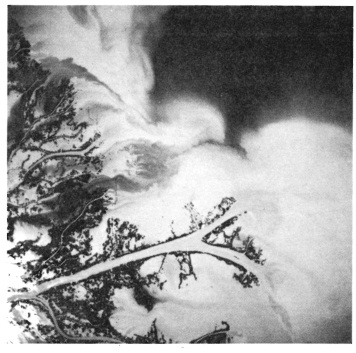
Figure 1 High-altitude photograph of bifurcating distributary channel in the Mississippi River delta.[7]
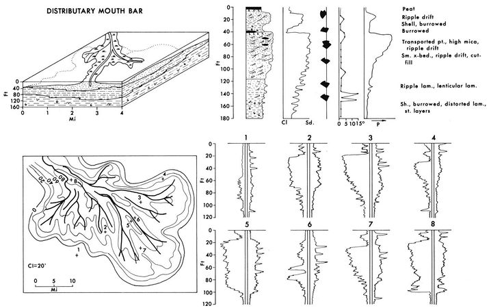
Figure 2 Summary diagram illustrating the major characteristics of the distributary-mouth bar deposits in the subaqueous delta plain.[7]


In the absence of high tidal range and extremely strong marine energy, the distributary channel pattern is often one of seaward bifurcation (Figure 1). Because of this bifurcating channel pattern, the distributary-mouth bars at each of the river mouths often merge and form a near-continuous sand strip around the entire periphery of the delta. Shallow offshore slopes and low wave and tide action favor this type of distributary pattern, and turbulent diffusion within the water mass becomes restricted to the horizontal. Bottom friction plays a major role in causing effluent deceleration and expansion. Initially a broad, arcuate radial bar will form at the mouth. However, as deposition on the bar continues, natural subaqueous levees will develop beneath the lateral boundaries of the expanding effluent, where velocity gradients are generally steepest. Development of subaqueous levees tends to inhibit further increases in effluent expansion, so that with continuing bar accretion continuity can no longer be maintained simply by increasing effluent width. As the central part of the bar grows upward, channelization develops along the threads of maximum turbulence, which tend to follow the subaqueous levee. This process results in formation of a bifurcating channel, which has a triangular middle ground shoal separating diverging channel arms. This type of channel pattern is well displayed in the high-altitude photograph shown as Figure 1.

The upper left diagram of Figure 2 illustrates schematically the process of a bifurcated channel. In the cross sections on this panel, the three major units illustrated include lower prodelta clays, overlain by alternating silt and sand units of the distal bar, and uppermost, distributary-mouth-bar sands. As the diagram shows, distributary-mouth-bar sands form a nearly continuous sand body extending laterally large distances. The upper right-hand diagram shows the most common vertical sequence within the distributary-mouth-bar deposits and some of its characteristics. The unit generally displays a coarsening-upward sequence in which depositional dips are extremely low, rarely exceeding 1° except in areas where slump deposits result in high angles within the mass-moved sediment. Figure 3A and B illustrates some of the characteristic structures found within the lowermost units of prodelta clays. Parallel, colored clay laminations, thin graded silt and silty clay parallel laminations, bioturbation (generally confined to the clay laminations), and slump structures are common within the prodelta deposits. Microfaunal remains generally indicate marine deposition, and diversity of species is generally quite high, indicating an open, inner to outer shelf depositional environment. These deposits display most of the characteristics of normal marine shelf deposits and are differentiated only by their rate of accumulation.
For a given length of time, prodelta deposits are thicker (because of high sedimentation) than an equivalent section of normal marine shelf deposits. Rapid deposition often results in slightly lower amounts of bioturbation and deposits displaying excess pore fluid pressures. Graded bedding zones are sometimes present in the prodelta deposits, but are rarely found in normal marine shelf deposits. X-ray radiography of the cores reveals that many of the parallel laminations are defined either by inclusions of diagenetic origin or extremely slight differences in textural characteristics. Because of the high rates of deposition normally associated with prodelta deposits, intense bioturbation is usually confined only to the lowermost parts of the deposit, where it grades downward into norma open-marine shelf environments, that often show intense bioturbation.
Progressing upward within the vertical sequence, the distal bar (also referred to as delta front or delta platform) overlies the prodelta facies. This environment is the seaward-sloping margin of the advancing delta sequence. Increase in sedimentation rates and coarseness of sediments are characteristic of this environmental sequence.
Lithologically, the sediments primarily consist of laminated silts and clays containing numerous thin-graded and cross-laminated sand-silt layers. Depositional slopes, although higher than in any other subaqueous delta environment, rarely exceed 0.5 to 0.75°. Core photographs in Figure 3D-F show some of the more common structural types associated with distal-bar deposits. Lower parts of the distal bar show small burrows and shell remains generally scattered throughout the deposits, that often result in partial destruction of parallel and lenticular laminations (Figure 3D). Higher in the distal bar deposits, a wide variety of structures associated with both oscillatory and unidirectional currents become much more common. Sedimentary structures such as small-scale cross laminae, starved current ripples, small scour and fill, and graded sand units become much more common. In general the amount of clays and silty clays begins to diminish within the section.
Figure 3F illustrates the wide variety of sedimentary structures found within only a 20-cm core from the uppermost parts of this environmental sequence. The clays, when present, are generally extremely thin, with lateral continuity of individual clay laminations usually low. Distal-bar deposits represent potential reservoirs in the subsurface, and numerous gas fields in such deposits have been located in the Pleistocene deposits of offshore Texas.
The distributary-mouth bar is the area of shoaling associated with the seaward terminus of a distributary-mouth channel. Shoaling is a direct consequence of a decrease in velocity and a reduction in carrying power of a stream as it leaves the confines of its channel. Accumulation rates are extremely high, probably higher than in any other environment associated with the delta. In some places depositional rates of coarse sediments at the mouth of the Mississippi reach 1 to 3 m per year.
The sediments are constantly subjected to reworking, not only by stream currents but by waves generated in the open-marine waters beyond the channel mouth. A general understanding of the processes and mode of formation of the distributary-mouth bar is critical to understanding the evolution and vertical relationships illustrated in Figure 2. As the low-density, turbid, fresh river water flows out of the distributary mouth over denser saline marine waters, the lighter effluent waters expand and lose velocity. Coarser sediments (the sands) settle rapidly, both from suspension and bedload migration, and almost all of the sand is deposited within the vicinity of the distributary mouth.
Because of variations in turbulence at the river mouth and different process intensities between low river stage and high river stage, silts and clays will occasionally be deposited with sands in this environment. However, reworking by marine and riverine processes results in cleaning and sorting of the sediments. As a result, the distributary-mouth bar commonly consists of clean, well-sorted sand and thus is obviously a potential reservoir rock for hydrocarbons. The remaining finer grained suspended load carried by the river is distributed widely by the expanding river effluent and forms distal bar and prodelta environments.
The most common sedimentary structure consists of a variety of small-scale cross laminae and current ripple drift types (Figure 3G-I). Quite often mass-movement processes such as small localized slumps result in distorted laminations. This is particularly true near lower sections of the distributary-mouth-bar sequence, where over-pressured sediments are much more common. Figure 3G illustrates one type of slump structure commonly seen. Near the top of the distributary-mouth bar large accumulations of river-transported organic debris are often present. Water-saturated logs and other organic debris are transported down the rivers in times of flood and discharged into the nearshore zone, where wave action grinds down the coarser wood particles into large concentrations of organic debris. Figure 3I is a core showing some of the organic laminations present within the upper part of the sand body.
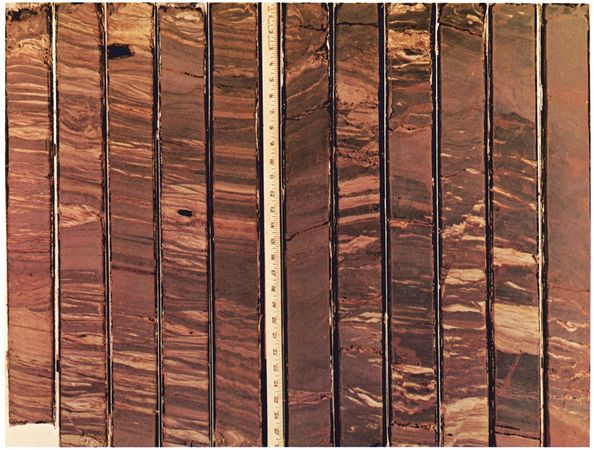
Figure 4 Part of a continuously cored boring through the distributary-mouth bar sequence. This section represents the lower part of the distal bar deposit. Diameter of cores is 8 cm (3 in.).[7]
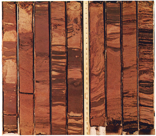
Figure 5 Part of a continuously cored boring through the distributary-mouth bar sequence. This section represents the lower part of the distributary-mouth bar deposit. Diameter of cores is 8 cm (3 in.).[7]
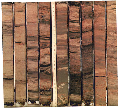
Figure 6 Part of a continuously cored boring through the distributary-mouth bar sequence. This section represents the upper part of the distributary-mouth bar deposits. Diameter of cores is 8 cm (3 in.).[7]


Directly capping the distributary-mouth bar are a variety of overbank splays and shallow-bay deposits. These overbank splays are commonly referred to as natural levees. During annual river floods, the river stage normally tops the distributary channel, and numerous small overbank or crevasse splays result. Each splay will be maintained for one or several years until it builds up or grades the natural levee to flood level, and then it will cease activity. Thus, capping the distributary-mouth bar is commonly a series of small coarsening-upward sequences representative of these splay deposits. Deposits are characterized by a wide variety of sedimentary structures, with climbing current ripples and small-scale cross laminae being the most common in the coarser grained parts. Figure 3J illustrates some of the ripple-type structures present in this environment.
Figures 4, 5, and 6 show parts of a continuously cored boring (approximately 130 m in depth) taken through the distributary-mouth-bar deposits in the Mississippi River delta. Figure 4 illustrates the sedimentary structures in the core representing lower sections of the distal-bar deposits. Even within this 10 m section of core the change from a predominance of clay in the lower part of the distal bar to a predominance of fine, silty and sandy laminations is apparent. Several regions show highly contorted bedding believed to be primarily due to slumping rather than coring processes.
Figure 5 represents approximately 7 m of core taken in the lower segment of the distributary-mouth-bar deposits. The predominance of sand laminations intercalating with silty clay and silt laminations is apparent. Darker colored zones in lower parts of the core represent transported organic debris. Also shown in this sequence is a section of highly contorted core, once more believed to be the result of slumping rather than core disturbance. The predominance of small-scale ripple laminations is obvious within the sequence. Figure 6 represents 7 m of cored boring taken from the uppermost part of the distributary-mouth-bar deposit. The core consists primarily of sand deposits, with sand-sized particles making up 80 to 90% of the total unit. Dark layers are stratification representing transported organic debris. Note that most of the stratification is nearly flat-lying, and few or no steep dips exist, except for small-scale cross-bedding. One core indicates tremendous disturbance and distortion of lamination and undoubtedly represents a portion of a slump block. Ripple laminations, climbing ripples, and larger scale trough cross-laminations are the most dominant sedimentary structure types.
The lower two diagrams on Figure 2 represent a sand isopach map of a distributary-mouth-bar system in which individual distributary-mouth bars have merged, forming a delta-front sand body type. The distributary pattern is shown as solid dark lines. A boring through the distributary channel itself would show very erratic sand distribution in the distributary channel. Electric-log responses and their variations are shown in the lower right-hand diagram of Figure 2. Most borings show a coarsening-upward sequence, with the sand body varying in thickness, depending on the location of the core with reference to the distributary channels themselves. In general, the nearer the boring to the axis of the distributary, the sharper the base of the sand body, and gradational contacts become less well defined. Distally (away from the distributary-channel axis), the sequence displays a much greater tendency toward a large transition from distal bar to distributary-mouth bar.
River-mouth tidal-ridge deposits[edit]
The distributary-mouth-bar sequence just described represents the most common type of vertical sequence within many deltaic deposits. In deltas debouching into macro- or high-tidal ranges and into narrow, elongate basins, however, tidal processes play an important role in dispersing and redistributing fluvial clastics. Where rivers debouch into narrow, elongate basins where tidal range creates strong bidirectional transport, large linear tidal ridges within and just seaward of the river mouth are common topographic forms associated with the distributary-mouth-bar environment. These ridges are commonly composed of coarse fluvial sand and vary in size, some displaying heights exceeding 30 m above the adjacent swales. The ridges are commonly oriented parallel with the river channels forming elongate prominent sand deposits.
Although in present world deltas, river-mouth tidal ridges form one of the major sand bodies associated with rivers prograding into basins displaying macro- or high-tidal ranges, literature on these river-mouth tidal ridges is sparse. Many past river deltas undoubtedly existed in similar environmental settings, and they must therefore form prominent sand bodies in many ancient-rock deltaic sequences. Major literature associated with these types of features includes that of Off,[8] Keller and Richards,[9] Reineck and Singh,[10] Houbolt,[11] Klein,[12] Ludwick,[13] Meckel,[14] and Wright and Thom.[15]
River distributaries debouching into high-tidal regions commonly display a funnel-shaped configuration, with widths attaining several kilometers. Linear, elongate tidal ridges aligned parallel with each other in the direction of tidal flow are the most prominent channel and river mouth accumulation forms. They appear to be directly related to bidirectional sediment transport patterns, high-tidal amplitudes, and tidal-current symmetry. Tidal ridges described by Coleman[16] and Wright and Thom[15] in the Ord River are typical of the study shoals found in river-dominated deltaic distributaries.
Those tidal ranges in the Ord River range in relief from 10 to 22 m and compositely account for over 5 x 10⁶ cu m of total sand accumulation. Tidal ridges average roughly 2 km in length and 300 m in width, with crests emergent or near the surface at low tide. A few are permanently emergent and vegetated by mangrove. In some deltas, tidal ridges attain extreme lengths of 10 to 15 km. Deltas displaying similar types of shoals have been described by Off[8] and Meckel.[14] Meckel[14] referred to tidal ridges at the mouth of the Colorado delta, Gulf of California, as tidal bars. Ridges at the mouth of the Colorado display relief of 7 to 10 m and a crest to crest spacing of several kilometers. In cross-sect on they vary from roughly symmetrical to distinctly asymmetrical, with steep sides commonly facing the downstream direction of tidal propagation.

Although little coring has been done on these types of deposits, Figure 7 is an attempt to summarize data presently available. The upper left diagram illustrates the distribution of some of the tidal ridges seaward of the mouth of the Shatt-el-Arab River delta, which flows into the Persian Gulf. Lengths of the tidal ridges at the river mouth range from 5 to 15 km, with some of the larger ridges displaying widths of 2 km. General spacing of the ridges across the distributary-mouth-bar area ranges from a minimum of about 2 km to slightly over 5 km. The upper righthand diagram shows a typical vertical sequence resulting from river-mouth progradation and lateral migration of ridges. In general, the coarsening upward sequence displayed agrees quite well with data presented from the lower Colorado delta[14] and Ord River delta.[16]
Sand units are generally well sorted and display a variety of small-scale and large-scale cross-stratifications. One of the more common sedimentary structures within sand bodies is the small-scale bidirectional or herring-bone stratification type. Shell debris is generally common, both scattered throughout sand deposits and concentrated into thin lag-type deposits. Parallel sand layers are common throughout the entire sequence of sandy deposits and probably result from deposition during the upper flow regime, especially during low tide, when water depths across the shoals are quite low and velocities are quite high.
Thompson[17] measured flood and ebb currents of 100 to 135 cm/sec, with maximum velocities of more than 200 cm/sec, in bars at the mouth of the Colorado. Although exposures are generally limited within the tidal ridges, shallow pits and box cores near the tops of many tidal ridges have large-scale trough cross-bedding, with the probabilities that within the uppermost sequences, large-scale cross-bedding could be preserved. Directional properties throughout the sequence generally show a net downstream direction; however, upstream-oriented cross-stratification is not uncommon, and thus current roses would probably show the bidirectional pattern.
The lower left diagram in Figure 7 depicts the probable sand isopach associated with a river-mouth tidal-ridge environment. This particular isopach is based on limited data and is patterned after the Ord River mouth. Sand thickness throughout the isopached interval would undoubtedly vary and be concentrated into the linear type of ridges seen topographically in modern deltas. Log response (lower right diagram, Figure 7) displays extreme variation because of sand thickness; the base of the sand deposit displays a gradational contact to a rather abrupt basal scour plane associated with those ridges of prominent scour. In general, the ridges tend to display the coarsest and best sorted sand units and are illustrated by core holes 3, 5 and 7.
In an upstream direction, depicted by core hole 8, it is highly probable that the base of the sand represents a scoured surface, and thus the sand body displays an extremely sharp base. In drop cores and samples from interridge-ridge areas, sediments tend to be much more poorly sorted. Clay clasts, organic trash, and shell lags are common. It is probable that electric-log response would show extremely erratic and ragged types of patterns as indicated in bore holes 4 and 6.
Although data are sparse from this type of environmental setting, the writers believe such sand bodies to be indeed common in ancient rock sequences, and until a larger number of cored borings and cores on and through these river-mouth tidal ridges are obtained, data presented in Figure 7 remains somewhat speculative. However, observations from literature cited above indicate that the general nature of the deposits is as illustrated in the vertical sequence of Figure 7.
Subaqueous slump deposits[edit]
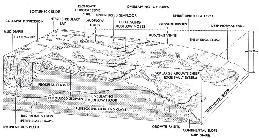
Figure 8 Schematic illustrating depicting the major types of submarine landslides, diapirs, and contemporary faults in the Mississippi River delta. [7]
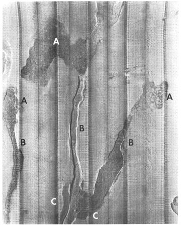
Figure 9 Side-scan sonar mosaic of subaqueous landslide gullies in the Mississippi River delta. The width of the mosaic is 1.5 km, and the superimposed grid is a 25-m square. The slope is from top (approximately 10-m water depth) to bottom (water depth 60 m).[7]


Recent detailed marine geologic investigations on subaqueous parts of continental shelves seaward of many river deltas experiencing high depositional rates have revealed contemporary recurrent subaqueous gravity-induced mass movements as common phenomena worthy of consideration as an integral component of the normal deltaic process and marine sediment transport. Off river deltas such as the Mississippi, Magdalena (Colombia), Orinoco (Venezuela), Surinam (Surinam), Amazon (Brazil), Yukon (Alaska), Niger (Nigeria), Nile (Egypt), and Hwang-Ho (China), subaqueous slumping and downslope mass movement of sediments are common processes. Instabilities and mass movement of sediment in these regions generally display the following characteristics: (a) instability occurs on very low angle slopes (generally less than 2°); (b) large quantities of sediment are transported from shallow water to deeper water offshore along well-defined mudflow gullies (debris flows) and in a variety of translational slumps. Although individual mudflow features vary in size and frequency, they generally possess a source area consisting of subsidence and rotational slumping, an elongate, often sinuous chute or channel (mudflow gully), and a composite depositional area composed of overlapping lobes of remolded debris.
River deltas displaying an abundance of submarine landslides are generally characterized by high rates of sediment accumulation within both fine-grained and coarse-grained fractions. Sediments therefore have an extremely high water content and most commonly display excess pore fluid pressures.
The abundance of fine-grained organic material within fine-grained clays is also subjected to rapid degradation by biochemical processes and produces large accumulations of sedimentary gas (primarily methane and carbon dioxide). The basic conditions for failure exist when stresses exerted on the sediment are sufficient to exceed its strength. This can be due to stress increases, strength reduction, or a combination of the two.
The Mississippi River delta and adjacent shelf region have been sites of active investigation for decades. The past decade has seen substantial advances in the systematic utilization of various techniques for marine geological exploration. Application of side-scan sonar and high-resolution seismic techniques has allowed substantial improvements in documentation and mapping of subaqueous flowslides off the delta. Essentially the entire subaqueous part of the Mississippi delta has been covered with overlapping side-scan sonar imagery and high-resolution seismic lines on a grid spacing of 250 m. Using these techniques, and aided by a large number of off-shore foundation borings, Coleman et al.,[18] Coleman,[16] Coleman and Garrison,[19] and Prior and Coleman[20] [21] [22] have identified a wide variety of slope deformational features. These data form the basis for the following discussion of subaqueous mass-movement deposits.
The main types of slope and sediment instability mapped in 5- to 300-m water depths are illustrated schematically in Figure 8, which shows their distribution around a single distributary. Similar spatial organization can be identified around the entire periphery of the modern river delta. Although a large number of types have been identified, the major types having geological significance include peripheral slumping, elongate retrogressive slides and mudflow gullies (and their associated overlapping depositional lobes), and large shelf-edge arcuate slumps and contemporaneous faults.
Peripheral slumps are associated primarily with immediate distributary-mouth-bar deposits. Bottom slopes in this region range from 0.2 to 0.6°. Peripheral slumps display abrupt stair-step scarps on the seafloor, the heights of the scarps ranging from 3 to 8 m. Tensional cracks are often present upslope from the major scarp, and frequently small mud vents are associated with these scarps.
Sizes of the slump blocks vary considerably, ranging from only a few hundred meters to well over 3 km. Although the features are referred to as rotational types of slumps because of the extremely low-sloping bottom gradients, the major movement is translational downslope. Displacements of the sediments begin as shallow rotational slumps, continuing over basal shears as predominantly translational movement.
Depth of the shear plane, and hence the thickness of the block, varies, but rarely exceeds 35 m. Movement rates are hard to determine, but repeated surveys over a 1-year period display movements ranging from a few hundred meters to nearly 1,000 m. This type of block slumping results essentially in downslope movement of sediment from shallow-water environments to deeper offshore and outer continental shelf water depths. Since the features originate in and near the distributary-mouth bar, they are frequently responsible for carrying coarse distributary-mouth bar sands farther offshore into deeper waters.
Instability of a second major type consists of elongate, retrogressive mudflow gullies and their overlapping depositional lobes. These features extend radially seaward from each major distributary and occur in water depths from 10 to 100 m. Depositional lobes extend farther seaward to water depths as great as 300 m. Each feature possesses a long, narrow chute or channel linking a depressed, hummocky source area on the upslope end to composite overlapping depositional lobes of fans on the seaward end. Figure 9 is a side-scan sonar mosaic of several of these mudflow gullies. Source areas are normally bowl shaped and bounded by distinct scarps (Figure 9, A), with the interior of the depression normally characterized by extremely hummocky, chaotically arranged blocks of clasts in a matrix of highly fractured, flowed sediments.
Narrow chutes or gullies (Figure 9, B) extend downslope at approximately right angles to the regional depth contours and achieve lengths exceeding 8 to 10 km. They are rarely straight, and in plan view they display high sinuosity, with alternating narrow constrictions and wide bulbous sections. Widths of the gullies range from 20 to 50 m at the narrow section to 600 to 800 m where gullies are widest. Gully floors are generally depressed from a few meters to 20 m below the adjacent intact bottom. Slopes of side walls range from 1° to highs of 15°, and small rotational side slumps are often apparent.
During failure and movement of sediments, the material is apparently viscous enough to occasionally be ejected out of the narrow channel, forming overbank or natural-levee-type splays (Figure 9, C). On seaward ends of the elongate chutes, broad overlapping composite depositional lobes composed of debris discharged from the gullies are present. Depositional lobes display extremely irregular bottom topography characterized by crenulated blocky, disturbed debris and often abundant mud vents and volcanoes. Seaward mud nose scarps range in height from a few meters to more than 25 m. In plan view, scarps are curved and adjacent lobes often coalesce, forming an almost continuous complex sinuous frontal scarp possibly extending for distances of 20 to 25 km more or less parallel with the bathymetric contours.
Depositional areas are composed of several overlapping lobes owing to periodic discharge events, and each discharge is associated with its own distinctive nose. Seaward of the edge of the lobes, extensive small-scale pressure ridges are arranged sinuously and parallel. Extensive fields of mud vents and volcanoes emitting gas, water and fluid mud are found associated with the lobes and directly seaward of the noses; these undoubtedly result from rapid loading of underlying sediment as well as consolidation processes within the debris itself. Thicknesses of the lobes are difficult to determine, but each distinct lobe is normally 20 or so meters thick, and because of overlapping, the total thickness of mudflow can often approach 50 to 60 m. In one area of the Mississippi River delta, in water depths of approximately 200 to 250 m, depositional lobes cover approximately 770 sq km with discharged debris volume of 11.2 x 10⁶ cu m.
A third major type of sediment instability of significant geological importance is arcuate rotational slump and growth fault. This type commonly occurs on the outer continental shelf in front of the advancing or prograding deltaic system. Large, arcuate-shaped families of shelf-edge slumps and deep-seated contemporaneous faults tend to be active along the peripheral margins of delta fronts. In most instances, these large-scale features tend to cut the modern sediment surface, often forming localized scarps on the seafloor. These surface scarps provide localized areas for accumulation of downslope mass-moved shallow-water sediment. In many places shelf-edge slumps tend to give a stairstepped appearance to the edge of the continental shelf and are highly reminiscent of rotational peripheral slumps higher on the continental shelf, near the mouths of the modern distributaries. However, these features generally occur on a much larger scale and cut a column of sediment ranging from 50 to 150 m in thickness.
Lateral continuities of individual slump scarps range from a few kilometers to as much as 8 to 10 km, and scarps on the seafloor produced by this slumping process may have heights of 30 m. A similar type of slump is commonly referred to as a contemporaneous or growth fault and is the feature moving continuously along the shear plane with deposition. Hence with time and continued movements, offsets of individual marker beds increase with depth, and thickness of these beds increases abruptly across the fault.
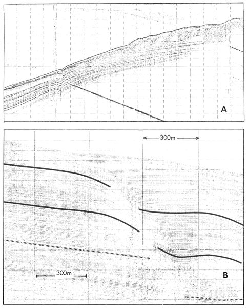
Figure 10 High-resolution seismic record run across an active growth fault seaward of the mouth of South Pass, Mississippi River delta. A. Seismic line showing active growth fault seaward of a large upslope mudflow. Note the increased thickness of sediment on the downthrown side of the fault. Horizontal scale is 300 m between shot points and vertical scale is 25 milliseconds per time line, or 19 m (62.5 ft). B. Detailed subbottom seismic record run across an active growth fault. Note the presence of a rollover structure and the increased accumulation of sedimentation on the downthrown side of the fault. Horizontal scale is 300 m between shot points and vertical scale is 10 milliseconds per time line, or 7.6 m (25 ft).[7]
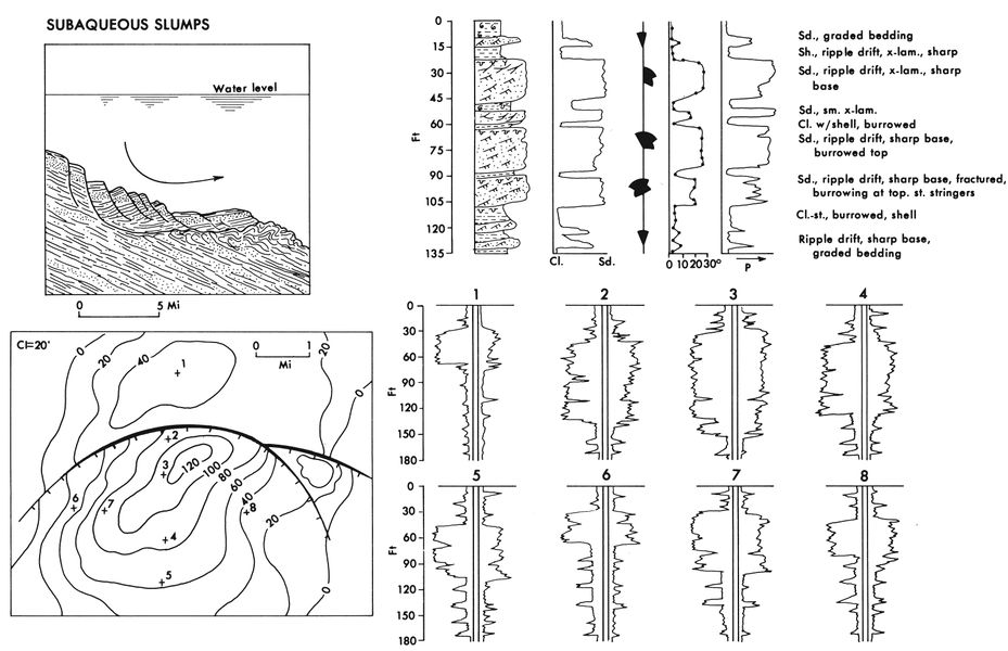
Figure 11 Summary diagram illustrating the major characteristics of slump deposits in the subaqueous delta plain.[7]


Figure 10 illustrates active growth faults in the Mississippi River delta seaward of the mouth of South Pass. Figure 10A shows a large mudflow lobe upslope from an active growth fault. This fault extends from the surface to depths beyond the bottom of the record. Sparker data run simultaneously indicate that the fault extends 700 to 750 m below sea bottom before merging into a bedding-plane fault. Offsets in the uppermost units are generally 5 to 10 m, while at depth (400 m), offsets of marker beds approach 70 to 80 m. Note the increased thickness of the sediment units on the downthrown side of the fault and the small rollover anticline or reverse-drag characteristic of this type of fault.
The amorphous zone upslope represents a surface mudflow that has progressed to and slightly beyond the limits of the faults. As surface mudflow crosses the fault zone, it thickens. It is highly possible that increased thicknesses on the downthrown sides of these faults result from movement of subsurface mudflows across the fault zone. As the fault zone is blanketed by a large mass of rapidly introduced mass-moved sediment, surface scarps on the seafloor are eliminated. Continued movement along the fault, however, will cause a new scarp, and given enough time, another mudflow will then move across the feature, adding increased amounts of sediment on the downthrown side.
This type of interaction between surface mudflow movements and contemporaneous faults may quite possibly play a large role in maintaining the continuing movement along these fault planes. Figure 10B shows details of the upper levels of a growth fault in the same vicinity.
A feature commonly associated with growth faults and of extreme importance to petroleum trapping is the association of rollovers or reverse drag with the downthrown side of a growth fault (Figure 10A, B). These features are common on the contemporaneous faults presently active in the delta. Rollover structures tend to form soon after deposition of sediment on the downthrown side and do not require a considerable amount of overburden and weighting to form. Mass-moved material flowing downslope from higher levels on the delta front (sands, silts, and clays) contains high water and gas contents. It is speculated that, as sediment accumulates slightly more thickly on the downthrown side of the fault, early degassing and dewatering associated with movement along the fault take place. Pore waters and pore gases are permitted to escape upward in the zone of movement associated with the fault, thereby decreasing the volume of sediment and allowing an early change in density to occur nearly contemporaneously with the fault. As greater and greater amounts of sediment are added and overburden pressures become increasingly larger, this feature is then amplified and becomes more pronounced with time and depth.
Figure 11 illustrates through a summary diagram some of the major characteristics associated with subaqueous slump deposits. Although boring control and core control are limited in deeper offshore waters, enough foundation borings have penetrated some of the sequences to give a fairly good indication of the deposit types accumulating offshore on the downthrown sides of some slump fault features. In addition, numerous articles on Gulf Coast Tertiary sequences indicate the type of deposition associated with slump deposits. The upper right-hand diagram illustrates a vertical sequence commonly associated with offshore slump deposits. The first striking characteristic is the extreme variations in grain size. Sandy deposits generally occur as distinct isolated blocks showing both sharp base and sharp tops. Grain size depends on the source of the slump material, and in such a deltaic setting, sources are commonly distributary-mouth-bar deposits trapped on the downthrown sides of these slump features.
Thus many sedimentary structures are the same as those described for distributary-mouth-bar deposits. Having been mass moved downslope, however, they lie on entirely marine clay deposits and thus normally have a sharp lower bounding surface. The upper surface is also usually extremely sharp and generally is characterized by a high degree of intensive burrowing on the top of the sand body. Because most of the deposits are mass moved, depositional dips increase significantly, and high-angle dips of 10 to 25° are not uncommon in these beds. Fracturing and localized faulting and slump structures are also abundant in most of the sand bodies.
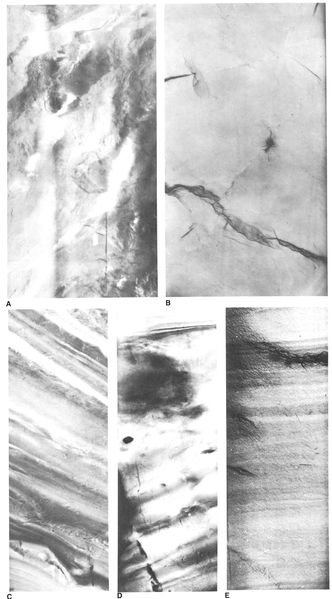
Figure 12 Core photographs of subaqueous slump deposits. Diameter of cores A, B, and E is 13 cm (5 in.) and of cores C and D 8 cm (3 in.). A. X-ray radiograph of highly distorted clay layers in marine deposits beneath the slump block. B. X-ray radiograph of multiple fracturing in clays in the shear plane zone. C. X-ray radiograph of silt and sand core in the slump block. Note that bedding is preserved with only minor fracturing but is tilted at angles of 20 to 30°. D. X-ray radiograph of disturbed structures in mudflow deposit that caps a slump block. E. X-ray radiograph of core in normally deposited marine clays, which often cap the slump deposits. ote the lack of disturbance in these deposits. [7]
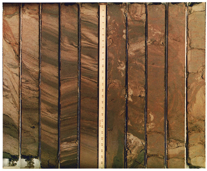
Figure 13 Part of a cored boring through a slump block composed of distributary mouth bars sands. This slump block is off Southwest Pass, Mississippi River delta, and is underlain and capped by marine clays. Diameter of cores is 8 cm (3 in.).[7]

Figure 14 Part of a core taken through a mudflow lobe on the continental shelf off the modern Mississippi River delta.[7]


Figure 12A-E illustrates specific types of stratification often encountered in finer grained sequences separating slumped sand blocks. Both normal bedded marine clay deposits (Figure 12E) and highly distorted marine clays (Figure 12A, B, D) are common within the finer grained sequences.
Figure 13 shows part of a cored boring through a slump block composed of distributary-mouth-bar sands. The core was taken in a buried slump block off Southwest Pass, Mississippi River delta. The sand unit is capped above and below by marine clays having faunal content that indicates middle to outer continental shelf depths. The sand body itself contains no fauna except for an occasional shallow-water microfossil. The thickness of the slump block cored is approximately 15 m, of which approximately 10 m is illustrated in Figure 13. The lowermost part of the sand body is characterized by extremely distorted sedimentary structures, with little or no primary stratification preserved. However, within the same slump block unit, well-preserved small-scale stratification exists as isolated blocks. There is a tendency for excessive dips to be present in the deposits, and fracturing systems such as those shown in the first two cores are also common within the sequences. The lateral extent of the sand body is relatively unknown, though additional borings in the area tend to show a minimum lateral continuity of at least 1 km. It seems highly probable that there is reservoir continuity across this particular sand body.
Figure 14 represents a part of a core taken through a mudflow lobe that moved down from shallower waters in the delta front across the continental shelf and on to outer continental slope water depths. This particular mudflow consists primarily of fine-grained silty clays of the distal bar and prodelta clay deposits. As is evident in the core, a wide variety of distorted laminations are present. Numerous fractures exist throughout the entire deposit; however, this particular depositional lobe has moved downslope from water depths of approximately 20 m and now lies at the edge of the continental shelf, where water depths are about 130 m (downslope movement of approximately 3 to 4 km). Even with this magnitude of movement, primary stratification is still preserved within individual block , as shown in the cored boring in Figure 14.
The lower two diagrams in Figure 11 attempt to illustrate a sand isopach map associated with a growth fault offshore, and accumulation of slump-block material on the downthrown side of a growth fault. This type of isopach is common in many of the published papers discussing Tertiary depocenters. Variations in electric-log response in various parts of the isopach map are shown in the lower right-hand diagram of Figure 11. One of the most characteristic features of sand bodies deposited by slumping processes is the extremely blocky character of the electric-log response. Sands generally tend to be sharp based, producing rather uniform log response. Correlation of individual kicks on the sand body is extremely tentative simply because of the nature of the slumping process. It is the writers' belief that many of the sand bodies associated with growth fault systems represent shallow-water sand bodies that have slumped downslope into deeper water and become trapped on the seafloor near growth fault systems.
In other instances, normal progradation of deltaic sequences across the growth fault zone results in thicker accumulations of mass-moved sediment on the downthrown side of the fault systems. Mass-moved sediment on the downthrown side is most common near the lower, more marine parts of the delta sequence.
Further reading[edit]
Literature on distributary-mouth-bar environments.
- Allen, J. R. L., 1965, Late Quaternary Niger delta and adjacent areas: AAPG Bulletin, v. 49, p. 547-600.
- Allen, J. R. L., 1970, Sediments of the modern Niger Delta: in J. P. Morgan, ed., Deltaic sedimentation: modern and ancient: SEPM Spec. Pub. 15, p. 138-151.
- Arnborg, L. E., 1948, The delta of the Angerman River: Geog. Ann., Stockholm, v. 30, p. 673-690.
- Bagans, B. P., J. C. Horne, and J. C. Ferm, 1975, Carboniferous and Recent Mississippi lower delta plains: Gulf Coast Assoc. Geol. Soc. Trans., v. 25, p. 183-191.
- Belt, E. S., 1975, Scottish carboniferous cyclothem patterns and their paleoenvironmental significance: in M. L. Broussard, ed., Deltas, models for exploration: Houston Geol. Soc., p. 427-449.
- Coleman, J. M., 1976, Deltas: Processes of deposition and models for exploration: Continuing Education Publ. Co., Champaign, IL (now available from Burgess Publishing Co., Minneapolis, MN), 102 p.
- Coleman, J. M., S. M. Gagliano, and W. G. Smith, 1970, Sedimentation in a Malaysian high tide tropical delta: in J. P. Morgan, ed., Deltaic sedimentation: modern and ancient: SEPM Spec. Pub. 15, 312 p.
- Ferm, J. C., 1970, Allegheny deltaic deposits: in J. P. Morgan, ed., Deltaic sedimentation: Modern and ancient: SEPM Spec. Pub. 15, 312 p.
- Ferm, J. C., 1977, Allegheny deltaic deposits: in F. B. van Houten, ed., Ancient continental deposits: Benchmark Papers in Geology: Stroudsburg, Pa., Dowden, Hutchinson and Ross, 384 p.
- Fisher, W. L., and J. H. McGowen, 1967, Depositional systems in the Wilcox Group of Texas and their relationship to oil and gas: Gulf Coast Assoc. Geol. Soc. Trans., v. 17, p. 105-125.
- Fisk, H. N., et al, 1954, Sedimentary framework of the modern Mississippi delta: Jour. Sed. Petrology, v. 24, p. 76-99.
- Fisk, H. N., 1955, Sand facies of Recent Mississippi delta deposits: 4th World Petroleum Cong. Proc., Rome, sec. 1, p. 377-398.
- Fisk, H. N., 1961, Bar-finger sands of the Mississippi delta: in J. A. Peterson and J. C. Osmond, eds., Geometry of sandstone bodies: AAPG Special Publications 22, p. 29-52.
- Fisk, H. N., and E. McFarlan, Jr., 1955, Late Quaternary deltaic deposits of the Mississippi River--local sedimentation and basin tectonics: in A. Poldervaart, ed., Crust of the earth, a symposium: Geol. Soc. America Spec. Paper 62, p. 279-302.
- Horne, J. C., et al, 1978, Depositional models in coal exploration and mine planning in Appalachian region: AAPG Bulletin, v. 62, no. 12, p. 2379-2411.
- Johnston, W. A., 1922, The character of the stratification of the sediments in the recent delta of the Fraser River delta, British Columbia, Canada: Jour. Geology, v. 30, p. 115-129.
- Kolb, C. R., and J. R. Van Lopik, 1966, Depositional environments of the Mississippi River deltaic plain, southeastern Louisiana, in M. L. Shirley and J. A. Ragsdale, eds., Deltas: Houston Geol. Soc., p. 17-62.
- Kruit, C., 1955, Sediments of the Rhone delta, 1, Grain size and microfauna: Kon. Nederlands Geol. Mijnb. Gen. Verhand., v. 15, p. 397-499.
- Maldonado, Andres, 1975, Sedimentation, stratigraphy, and development of the Ebro Delta, Spain: in M. L. Broussard, ed., Deltas, models for exploration, 2nd ed: Houston Geol. Soc., p. 311-338.
- Mikhailov, V. N., 1966, Hydrology and formation of river mouth bars: in Scientific problems of the humid tropic zone deltas and their implications: UNESCO, Proc. Dacca Symp., p. 59-64.
- Oomkens, E., 1967, Depositional sequences and sand distribution in a deltaic complex: a sedimentological investigation of the post-glacial Rhone delta complex: Geologie en Mijnbouw, v. 46, no. 7, p. 265-278.
- Oomkens, E., 1974, Lithofacies relations in the Late Quaternary Niger delta complex: Sedimentology, v. 21, p. 195-221.
- Scruton, P. C., 1955, Sediments of the eastern Mississippi Delta: in Finding ancient shorelines: SEPM Spec. Pub. 3, p. 21-51.
- Scruton, P. C., 1956, Oceanography of Mississippi Delta sedimentary environments: AAPG Bulletin, v. 40, p. 2864-2952.
- Shepard, F. P., 1956, Marginal sediments of the Mississippi delta: AAPG Bulletin, v. 40, p. 2537-2623.
- Shepard, F. P., F. B. Phleger, and T. H. van Andel, eds., 1960, Recent sediments, northwest Gulf of Mexico: [AAPG Special Publication 21, 394 p.
- Shirley, M. L., ed., 1966, Deltas: Houston Geol. Soc., 251 p.
Literature on subaqueous slumps.
- Bea, R. G., 1971, How sea floor slides affect offshore structures: Oil and Gas Jour., v. 69, no. 48, p. 88-92.
- Busch, D. A., 1975, Influence of growth faulting on sedimentation and prospect evaluation: AAPG Bulletin, v. 59, p. 217-230.
- Bruce, C. H., 1972, Pressured shale and related sediment deformation: a mechanism for development of regional contemporaneous faults: Gulf Coast Assoc. Geol. Soc. Trans., v. 22, p. 23-31.
- Carlson, P. R., 1978, Holocene slump on continental shelf off Malaspina Glacier, Gulf of Alaska: AAPG Bulletin, v. 62, no. 12, p. 2412-2426.
- Coleman, J. M., 1976, Deltas: Processes of deposition and models for exploration: Continuing Education Publ. Co., Champaign, IL (now available from Burgess Publishing Co., 7108 Ohms Lane, Minneapolis, MN 55435), 102 p.
- Coleman, J. M., and L. E. Garrison, 1977, Geological aspects of marine slope instability, northwestern Gulf of Mexico: Marine Geotechnology, v. 2, p. 9-44.
- Coleman, J. M., and D. B. Prior, 1978, Contemporary gravity tectonics--an everyday catastrophe? in Uniformitarianism--a contemporary perspective: AAPG Annual Meeting Abstract, v. 62, p. 505.
- Edwards, M. B., 1976, Growth faults in Upper Triassic deltaic sediments, Svalbard: AAPG Bulletin, v. 60, p. 341-355.
- Embley, R. W., and R. Jacobi, 1977, Distribution and morphology of large submarine sediment slides and slumps on Atlantic continental margins: Marine Geotechnology, v. 2, p. 205-228.
- Fisk, H. N., 1956, Nearshore sediments of the continental shelf off Louisiana: Proc. 8th Texas Conf. on Soil Mech. and Foundation Eng., p. 1-23.
- Garrison, L. E., 1974, The instability of surface sediments on parts of the Mississippi delta front: U.S. Geol. Survey Open File Rept., Corpus Christi, Texas, 18 p.
- Hedberg, H. D., 1974, Relation of methane generation to undercompacted shales, shale diapirs, and mud volcanoes: AAPG Bulletin, v. 58, no. 4, p. 661-673.
- Morgan, J. P., J. M. Coleman, and S. M. Gagliano, 1968, Mudlumps: diapiric structures in Mississippi Delta sediments, in J. Braunstein and G. D. O'Brien, eds., Diapirism and Diapirs: AAPG Memoir 8, p. 145-161.
- Molnia, B. F., P. R. Carlson, and T. R. Bruns, 1977, Large submarine slide in Kayak Trough, Gulf of Alaska: in Landslides: Geol. Soc. America Rev. Eng. Geol., v. 3, p. 137-148.
- Moore, D. G., 1961, Submarine slides: Jour. Sed. Petrology, v. 31, p. 343-357.
- Ocamb, R. D, 1961, Growth faults of south Louisiana: Gulf Coast Assoc. Geol. Soc. Trans., v. 2, p. 139-175.
- Prior, D. B., amd J. M. Coleman, 1978a, Disintegrating retrogressive landslides on very-low-angle subaqueous slopes, Mississippi Delta: Marine Geotechnology, v. 3, no. 1, p. 37-60.
- Prior, D. B., amd J. M. Coleman, 1978b, Submarine landslides on the Mississippi River delta-front slope: Geoscience and Man, v. XIX, p. 41-53: School of Geosciences, Louisiana State Univ., Baton Rouge.
- Rider, M. H., 1978, Growth faults in Carboniferous of Western Ireland: AAPG Bulletin, v. 62, no. 11, p. 2191-2213.
- Roberts, H. H., D. Cratsley, T. Whelan, III, 1976, Stability of Mississippi delta sediments as evaluated by analysis of structural features of sediment borings: Eighth Ann. Offshore Tech. Conf., Houston, Texas, May 3-5, 1976, p. 9-28.
- Shepard, F. P., 1955, Delta front valleys bordering the Mississippi distributaries: Geol. Soc. America Bull., v. 66, p. 1489-1498.
- Shepard, F. P., 1973, Sea floor off Magdalena delta and Santa Marta area, Colombia: Geol. Soc. America Bull., v. 84, p. 1955-1972.
- Whelan, Thomas, III, et al, 1975, The geochemistry of Recent Mississippi River delta sediments: gas concentration and sediment stability: Preprints 7th Ann. Offshore Tech. Conf., Houston, Texas, May 5-8, 1975, p. 71-84.
- Woodbury, H. O., et al, 1973, Pliocene and Pleistocene depocenters, outer continental shelf, Louisiana and Texas: AAPG Bulletin, v. 57, p. 2428-2439.
- Woodbury, H. O., J. H. Spotts, and W. H. Akers, 1977, Movement of sediment on Gulf of Mexico continental slope and upper continental shelf: 9th Offshore Tech. Conf., Proc., v. 1, p. 59-68.
See also[edit]
References[edit]
- ↑ Bates, C. C., 1953, Rational theory of delta formation: AAPG Bulletin, v. 37, p. 2119-2162.
- ↑ Scruton, P. C., 1960, Delta building and the deltaic sequence: in F. P. Shepard et al., eds., Recent sediments, northwest Gulf of Mexico: AAPG Special Publication 21, p. 82-102.
- ↑ Jopling, A. V., 1963, Hydraulic studies on the origin of bedding: Sedimentology, v. 2, p. 115-121.
- ↑ Borichansky, L. S., and V. N. Mikhailov, 1966, Interaction of river and sea water in the absence of tides: in Problems of the humid tropic zone deltas and their implications: UNESCO, Proc. Dacca Symp., p. 175-180.
- ↑ Wright, L. D., and J. M. Coleman, 1971, Effluent expansion and interfacial mixing in the presence of a salt wedge, Mississippi River delta: Jour. Geophys. Research, v. 76, no. 36, p. 8649-8661.
- ↑ Wright, L. D., 1974, Mississippi River mouth processes: effluent dynamics and morphologic development: Jour. Geology, v. 82, p. 751-778.
- ↑ 7.00 7.01 7.02 7.03 7.04 7.05 7.06 7.07 7.08 7.09 7.10 7.11 7.12 7.13 Coleman, J. M., and D. B. Prior, 1981, Deltaic environments of deposition, in P. A. Scholle and D. Spearing, eds., Sandstone depositional environments: AAPG Memoir 31, p. 139-178. Cite error: Invalid
<ref>tag; name "Colemanetal_1981" defined multiple times with different content - ↑ 8.0 8.1 Off, Theodore, 1963, Rhythmic linear sand bodies caused by tidal currents: AAPG Bulletin, v. 47, p. 324-341.
- ↑ Keller, G. H., and A. F. Richards, 1967, Sediments of the Malacca Straits, southeast Asia: Jour. Sed. Petrology, v. 37, p. 102-127.
- ↑ Reineck, H. E., and I. B. Singh, 1967, Primary sedimentary structures in the Recent sediments of the Jade, North Sea: Marine Geol., v. 5, p. 227-235.
- ↑ Houbolt, J. J. H. C., 1968, Recent sediments in the southern bight of the North Sea: Geol. en Mijnbouw, v. 47, p. 245-273.
- ↑ Klein, G. de V., 1970, Depositional and dispersal dynamics of intertidal sand bars: Jour. Sed. Petrology, v. 40, p. 1095-1127.
- ↑ Ludwick, J. C., 1970, Sand waves and tidal channels in the entrance to Chesapeake Bay: Old Dominion Univ., Inst. Oceanography, Tech. Rept. 1, 79 p.
- ↑ 14.0 14.1 14.2 14.3 Meckel, L. D., 1975, Holocene sand bodies in the Colorado Delta, Salton Sea, Imperial County, California: in M. L. Broussard, ed., Deltas, models for exploration, 2nd ed: Houston Geol. Soc., p. 239-265.
- ↑ 15.0 15.1 Wright, L. D., and B. G. Thom, 1975, Sediment transport and deposition in a macrotidal river channel: Ord River, Western Australia: Estuarine Research, v. II: New York, Academic Press, p. 309-321.
- ↑ 16.0 16.1 16.2 Coleman, J. M., 1976, Deltas: Processes of deposition and models for exploration: Continuing Education Publ. Co., Champaign, IL (now available from Burgess Publishing Co., 7108 Ohms Lane, Minneapolis, MN 55435), 102 p.
- ↑ Thompson, R. W., 1968, Tidal flat sedimentation on the Colorado River delta, northwestern Gulf of California: Geol. Soc. America Mem. 107, 133 p.
- ↑ Coleman, J. M., et al, 1974, Mass movements of Mississippi River delta sediments: Gulf Coast Assoc. Geol. Soc. Trans., v. 24, p. 49-68.
- ↑ Coleman, J. M., and L. E. Garrison, 1977, Geological aspects of marine slope instability, northwestern Gulf of Mexico: Marine Geotechnology, v. 2, p. 9-44.
- ↑ Prior, D. B., amd J. M. Coleman, 1978a, Disintegrating retrogressive landslides on very-low-angle subaqueous slopes, Mississippi Delta: Marine Geotechnology, v. 3, no. 1, p. 37-60.
- ↑ Prior, D. B., amd J. M. Coleman, 1978b, Submarine landslides on the Mississippi River delta-front slope: Geoscience and Man, v. XIX, p. 41-53: School of Geosciences, Louisiana State Univ., Baton Rouge.
- ↑ Coleman, J. M., and D. B. Prior, 1978, Contemporary gravity tectonics--an everyday catastrophe? in Uniformitarianism--a contemporary perspective: AAPG Annual Meeting Abstract, v. 62, p. 505.
External links[edit]
| find literature about Delta plain, subaqueous |