File:M106Ch04Fig2A.jpg

Original file (700 × 633 pixels, file size: 66 KB, MIME type: image/jpeg)
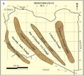
Paleogeographic maps of Libya. (A) Pan-African structures that formed during late Precambrian to Late Carboniferous tectonism. (B) Hercynian structural trends caused by the Late Carboniferous collision between Gondwana and Laurasia. Sources: Klitzsch (1971), Zegaar (1986), Anketell (1996), and Hallett (2002) 500 km (310.7 mi). From Hassan, H. S., and C. C. G. Kendall, 2014, Hydrocarbon provinces of Libya: A petroleum system study, in L. Marlow, C. Kendall, and L. Yose, eds., Petroleum systems of the Tethyan region: AAPG Memoir 106, p. 11-141.
File history
Click on a date/time to view the file as it appeared at that time.
| Date/Time | Thumbnail | Dimensions | User | Comment | |
|---|---|---|---|---|---|
| current | 19:44, 28 March 2016 |  | 700 × 633 (66 KB) | Molyneux (talk | contribs) | Paleogeographic maps of Libya. (A) Pan-African structures that formed during late Precambrian to Late Carboniferous tectonism. (B) Hercynian structural trends caused by the Late Carboniferous collision between Gondwana and Laurasia. Sources: Klitzsch (... |
You cannot overwrite this file.
File usage
The following page uses this file: