File:M106Ch12Fig04.jpg
Jump to navigation
Jump to search
No higher resolution available.
M106Ch12Fig04.jpg (700 × 215 pixels, file size: 27 KB, MIME type: image/jpeg)
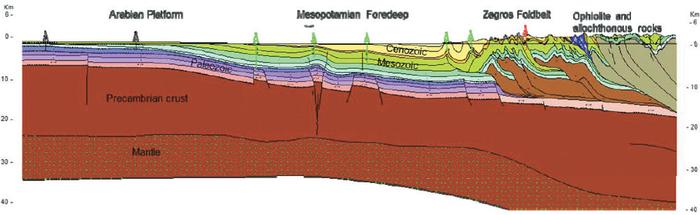
Regional geologic cross section, which extends NE across central Iraq, from the Arabian platform of southwestern Iraq, at the border with Saudi Arabia, across the Mesopotamian Foredeep and Zagros foldbelt in eastern Iraq and adjacent Iran, and ending at the Sirjan-Sanandaj zone in Iran. From Grabowski Jr., G. J., 2014, Iraq, in L. Marlow, C. Kendall, and L. Yose, eds., Petroleum systems of the Tethyan region: AAPG Memoir 106, p. 379-467.
File history
Click on a date/time to view the file as it appeared at that time.
| Date/Time | Thumbnail | Dimensions | User | Comment | |
|---|---|---|---|---|---|
| current | 13:55, 12 May 2016 | 700 × 215 (27 KB) | Molyneux (talk | contribs) | Regional geologic cross section, which extends NE across central Iraq, from the Arabian platform of southwestern Iraq, at the border with Saudi Arabia, across the Mesopotamian Foredeep and Zagros foldbelt in eastern Iraq and adjacent Iran, and ending a... |
You cannot overwrite this file.
File usage
The following page uses this file: