File:M114CH03FG02.jpg
Jump to navigation
Jump to search


Size of this preview: 451 × 599 pixels. Other resolutions: 181 × 240 pixels | 700 × 930 pixels.
Original file (700 × 930 pixels, file size: 155 KB, MIME type: image/jpeg)
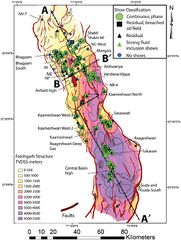
Depth-structure map constructed on top of the Fatehgarh Formation showing the main fields and important wells in the Barmer Basin together with the regional distribution of oil shows encountered in wells. See text for discussion of oil show classification and terminology (modified from Dolson et al., 2015). Geological cross sections of lines A–A’ and B–B’ are shown in Figure 3. From AAPG Memoir 114: Petroleum Systems Analysis—Case Studies, [Chapter 03].
File history
Click on a date/time to view the file as it appeared at that time.
| Date/Time | Thumbnail | Dimensions | User | Comment | |
|---|---|---|---|---|---|
| current | 17:48, 4 January 2019 | | 700 × 930 (155 KB) | Molyneux (talk | contribs) | Depth-structure map constructed on top of the Fatehgarh Formation showing the main fields and important wells in the Barmer Basin together with the regional distribution of oil shows encountered in wells. See text for discussion of oil show classificat... |
You cannot overwrite this file.
File usage
The following page uses this file: