File:NileDelta.jpg

Original file (689 × 700 pixels, file size: 161 KB, MIME type: image/jpeg)
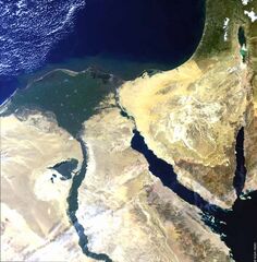
The contrast between the lush vegetation of the Nile delta and river course and the dry sand of the Sahara can be seen spectacularly in this enhanced true colour Medium Resolution Imaging Spectrometer (MERIS) image. The grey area to the bottom of the "triangle" of the delta is Egypt's Capitol, Cairo.
On the border between Israel and Jordan is the Dead Sea, at 412m below the level of the Mediterranean, the lowest point on earth. The Dead Sea also has salinity 10 times that of the Mediterranean, and due to the high evaporation rate in the area, salt accumulates, and can be extracted, as can be seen in the southern part of this large inland lake. The lighter blue/green areas are increased evaporite deposits, in this case salt. We can also see the structure of the saltpans crossed vertically by a canal.
ESA, 2003 http://bit.ly/1l8WdhM
File history
Click on a date/time to view the file as it appeared at that time.
| Date/Time | Thumbnail | Dimensions | User | Comment | |
|---|---|---|---|---|---|
| current | 18:06, 15 August 2014 | | 689 × 700 (161 KB) | Molyneux (talk | contribs) | The contrast between the lush vegetation of the Nile delta and river course and the dry sand of the Sahara can be seen spectacularly in this enhanced true colour Medium Resolution Imaging Spectrometer (MERIS) image. The grey area to the bottom of the "... |
You cannot overwrite this file.
File usage
The following page uses this file: