Land description and maps
| Development Geology Reference Manual | |

| |
| Series | Methods in Exploration |
|---|---|
| Part | Land and leasing |
| Chapter | Land description and maps |
| Author | James C. Tinkler |
| Link | Web page |
| PDF file (requires access) | |
Any person involved in the exploration, development, and production of oil and gas is usually exposed on a daily basis to property descriptions and oil and gas maps. Fundamental to property descriptions and maps is the principle that every tract of land or point on the earth is unique and distinguishable from any other tract or point—that is, if they are described in a legally sufficient manner.
The maps discussed here are limited to those that are typically called "land" maps in the oil and gas industry. Generally, land maps are planimetric, that is, they reflect a flat or horizontal surface that show the shape, dimensions, and extent of a given area or tract of land. In contrast to this, altimetric (commonly called topographic) maps, additionally reflect the variations in ground surfaces with respect to sea level.
Any point on earth can be identified in terms of latitude (east-west lines parallel to one another, with a base line located on the Equator), longitude (north-south circular lines all intersecting at the true north and south poles), altitude, and time.
Several commercial map companies have revolutionized map making and map sources for use in the oil and gas industry by using modern computer and satellite positioning devices and technology, all tied to base points that are defined, identified, and delineated by the U.S. Coast and Geodetic Survey.
Land maps[edit]
The land ownership map is one of the most valuable tools the landman uses because it synthesizes a majority of the information from the official records and files. The land map should serve as an overview of the activities in the area or region, along with the current lease status.
The following excerpts from a paper by Horace E. Rowald[1] provide a summary of pertinent information related to land descriptions and maps used in the onshore United States.[2]
[T]here is certain basic information contained..., such as
- Property identification by township, range, section, survey, or block
- Names of lessees and/or operators
- Status of leases—expiration date or held by production
- Surface land ownership
- Mineral ownership
- Well data (i.e., producing wells, dry holes, total depths drilled, operator's name, and occasionally, unit outlines and topographic information)
- Names of roads
- Names of streams
- Names of lakes
Information ... as symbols and abbreviations is explained by a legend.
Another commonly used map is the individual tract or unit survey plat. This is prepared by ... [a] civil engineer from an "on the ground" survey of a particular tract in connection with a drilling or development program. Common procedure is to establish on the ground boundary lines, as called for in the property description of the lease or deed, through a survey to determine the lines of use and occupancy (established by fences or other definite features). Variances between the property description and the lines of use and occupancy are reflected by the written report.
A set of symbols and abbreviations developed through the U.S. Geological Survey ... are used to identify specifically defined features.
Property descriptions[edit]
An accurate property description is one of the most important aspects of the conveyance. A defective description is one of the most frequent instances of title failure. In order for title to pass, the property description ... must describe the parcel of land so it can be identified and located on the ground.
The Rectangular System of Surveys, adopted by the U.S. Government, generally covers all lands west of the Mississippi except Texas, all states north of the Ohio River, and Alabama, Florida, and Mississippi.
[Editor's note: The systems used in the excepted states to describe land include sectionalized descriptions developed by each individual state, metes and bounds descriptions, or the use of lot, block, and subdivision descriptions.]
For example, 17 states, including the original 13 colonies, used a sectionalized basis to describe their land, in which ... townships six miles square were laid out, but grants within the township varied in size and shape, and do not conform with the U.S. Government's system.
Land grants were made by France, Spain, and Mexico in southwestern states such as Texas, Louisiana, and New Mexico prior to these lands becoming a part of the United States. These descriptions generally cover large blocks of land and are described by metes and bounds. Over area::30,000,000 acres of public domain in Texas were granted by the state to railroad companies... The basic unit of area used in laying out, locating, and surveying these lands was the section, which, for the most part, was a square mile. These sections frequently were assembled into blocks, with a number assigned to each section within the block and a number assigned to the block...
US rectangular system[edit]
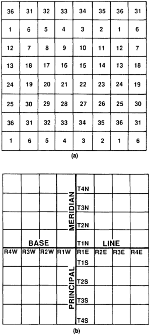
The rectangular survey system ... sets up what is known as "initial points," a position which is determined by accurate field astronomical methods. From these ... points, lines known as principal meridians and base lines are extended. The principal meridian line runs north and south conforming to the true meridian and extending from the initial point or monument. Regular township corners are established at intervals of 480 chains (distance::6 miles) along this line.
Figure 1 is an example of a U.S. Congressional Township. A standard Congressional Township contains 36 sections with area::23,040 acres of land. Normally, sections (nos.) 16 and 36 were ... set aside ... for school purposes, that essay writers can help with creating a detailed map project. Figure 2 is an example of a area::640 acre section and how it is subdivided and described in smaller components.
Due to the curvature of the earth, it is necessary to make corrections in the parallels and meridians... This is accomplished ... usually at intervals [of] 24 miles east and west of the principal meridians. This method produces the rectangular sections of area::640 acres each, with the sections along the north and west boundaries of the township absorbing the deficiency or excess in the measurements and convergence.
An important point is that patents from the United States use descriptions based upon the surveys, and they bind all parties ... as to the boundaries of land conveyed. The government can re-resurvey ... and change the acreage. The location of the lines may not be changed, even when surveying error is known.
Reading and applying descriptions from the rectangular survey system is made easier by following the whole description backwards. [Editor's note: For example, the southwest quarter (SW/4) of the northeast quarter (NE/4) of Section 24 would be analyzed by first looking at the NE/4 (area::160 acres) then going to the SW/4 within the NE/4, identifying area::40 acres. A correct way to describe this acreage would be as follows:
- Township 12 North, Range 10 West
- 14th Principal Meridian (T-12-N, R-lO-W, 14th PM)
- Section Twenty-four (24): Southwest quarter (SW/4) of the Northeast Quarter (NE/4).]
The system of rectangular surveys makes the proper identification of lands less complicated... However,... the placement of commas to show separate tracts is extremely important. Thus, the N/2 SW/4 is an area::80 acre tract, while the N/2, SW/4 comprises area::480 acres.
Metes and bounds descriptions[edit]
The metes and bounds description involves a method of describing a parcel of land by calls (course) and distances from an established beginning point and following boundary lines, either provided or given with terminal points and angles, back to the point of beginning.
A simplified version of a metes and bounds description would be as follows:
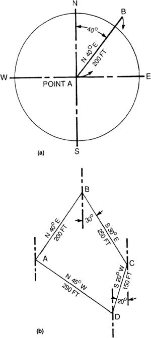
- Beginning at the ... Chestnut tree, which is the established northeast corner of the ... Revere Plantation; THENCE N 40° E 200′ to a stake for corner; THENCE S 30° E 250′ to a stake for corner; THENCE S 20° W 150′ to a stake for corner; THENCE N 45° W 290′ to the place of beginning.
Using a 360 degree compass, shown in Figure 3,... the plot of the above metes and bounds property description use[s] the following procedure:
- Place the center of the compass at the point of beginning of the line of course, designated as Point A in Figure 4a, with the north and south line of the compass coinciding with the line selected to be the north and south line of the map. [Editor's note: A course is the combination of the direction and length of any particular line, such as "north 40° east, 200 ft."]
- Then lay off 40 degrees from north toward the east and draw a line through this point. With the scale, measure off the first distance, which is 200 feet, and which will be Point B.
- ... The process is repeated using the data for the second course ... and for the remaining calls and distances, as shown in Figure 4b.
Metes and bounds descriptions are often lengthy and subject to error in the calls and distances... Many use a "deed reference" ... An example of a referenced description is as follows:
Being area::136.00 acres of land, more or less, a part of the M ... Russell Survey, A-12,... County, Texas, and being the same lands described in a warranty deed dated October 14, 1970, from ... to ..., recorded in Volume 126 page 583 of the Deed Records of County, Texas, to which deed reference is here made for a more complete description of said lands.
... The word describe rather than the word conveyed should be used ... because the ... deed may convey ... an interest different from what the parties intended.
Sectionalized descriptions[edit]
Sectionalized descriptions are used mostly in the states that established surveying systems of describing property prior to the establishment of the ... [U.S.] rectangular survey system. The following is an example ...:
- Being area::640.00 acres of land, more or less, Section (10) in Block (2) of the Katy and Brazos Railroad Company Survey, A-63, in ... County, Texas.
Lot and block descriptions[edit]
Lot and block descriptions usually refer to the lot number, block number, and subdivision plat number under which the subdivision is recorded... An example ... Lot 26, Block 74, of the town of Red Spring in Midland County, Texas, according to the Plat recorded in Volume 63, page 273, of the Plat Records of Midland County, Texas.
Offshore descriptions[edit]
As for the maps and descriptions used offshore United States, areas subject to state control use systems developed by each affected state that are tied to the onshore land system generally used in that state.
Maps and descriptions affecting federally controlled offshore interests are based on a series of maps designated by the Mineral Management Service (1984) as "Outer Continental Shelf Leasing Maps" and "OCS Official Protraction Diagrams." Each map has an identifier name, such as "Texas Map 8" or "NH 16-B" and, in most cases, a name such as "Sabine Pass Area" or "Destin Dome Area."
Each OCS map is divided into blocks that are generally three miles square (area::5760 acres), except those portions in offshore Louisiana lying in water depths less than distance::200 meters or along state or federal jurisdictional boundaries. The shallow water offshore Louisiana tracts are generally in the shape of a square, containing area::5000 acres. Boundary line tracts (between states or federal areas) vary in size and usually contain less than 5000 or area::5760 acres, respectively. In some frontier OCS areas, the Mineral Management Service has used larger tracts based on the metric system.
Because water depths are important to the geological and economic evaluations and the potential of offshore leases, the Mineral Management Service also has bathymetric maps available for use by the industry. Here is an example of a legal description set out in the Mineral Management Service (1984)[3] OCS procedures guide for use in federal waters:
- All of Block 397, Eugene Island Area, South Addition, OCS Leasing Map, Louisiana Map No. 4A and all of Block 4, Green Canyon, OCS Official Protraction Diagram, NS 15-3.
Another example is:
- That portion of Block 870, OCS Official Protraction Diagram, Mobile NH 16-4, which is more than three geographical miles seaward from the low water line off the coast of Mississippi and/or Alabama.
See also[edit]
- Functions of a petroleum landman
- Determining owners of oil and gas interests, and methods of conveyance
- Oil and gas contracts
- Nature of the oil and gas lease
References[edit]
- ↑ Rowald, H. E., 1984, Land maps and property descriptions: American Association of Landmen Comprehensive Land Practices, Chap. II, p. 1-13.
- ↑ Stamper, F. A., 1973, A Handbook of Texas Abstractors and Title Men: Austin, TX, Texas Land Title Assoc., p. 1-321.
- ↑ Mineral Management Service, 1984, Oil and Gas Leasing Procedures Guidelines, Gulf of Mexico Region: MMS, Department of the Interior, 188 p.


