Setting and structure of the Sorrento field
| Exploring for Oil and Gas Traps | |

| |
| Series | Treatise in Petroleum Geology |
|---|---|
| Part | Predicting the occurrence of oil and gas traps |
| Chapter | Predicting reservoir system quality and performance |
| Author | Dan J. Hartmann, Edward A. Beaumont |
| Link | Web page |
| Store | AAPG Store |
Index map

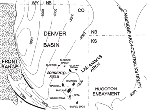
The Sorrento field is in southeastern Colorado on the north flank of the Las Animas Arch. The map in Figure 1 shows the location of the Sorrento field. Structure is contoured on the base of the Pennsylvanian.
Morrow structure map

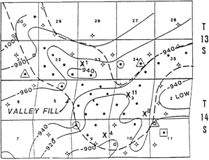
The Sorrento field reservoir is Pennsylvanian Morrow valley-fill sandstones. As shown in Figure 2, structure contours on a marker bed above the Morrow Sandstone reflect the irregular thickness of the sandstone body and a small structural nose and closure. The oil column is length::70 ft depth::(20 m) and exceeds structural closure. This is a combination structural-stratigraphic trap. Fluvial sandstones lap onto marine shale at the margins of the valley, forming lateral seals.
In Figure 2, circled wells represent Marmaton wells; triangles, Mississippian wells; and large X's, study wells. The rest of the oil wells produce from the Morrow. Each unit in the grid is 1 sq mi.
See also
- Evaluation of saturation profiles
- Morrow lithofacies and pore types
- Sorrento water saturation calculations
- Petrophysical analysis of Sorrento field wells
- Water saturation profile for Sorrento field