Difference between revisions of "Guará Formation"
Cwhitehurst (talk | contribs) |
Cwhitehurst (talk | contribs) |
||
| (7 intermediate revisions by the same user not shown) | |||
| Line 4: | Line 4: | ||
|competition=June 2015 | |competition=June 2015 | ||
}} | }} | ||
| − | The Guará Formation is a Late Jurassic sedimentary unit, outcropping on the southeastern edge of the Paraná Basin; in the western part of Rio Grande do Sul state (Brazil) and western Uruguay. It is described as fine to conglomeratic sandstones, deposited in arid to semiarid climate, composing fluvial channels and flood plains in the northern portion and aeolian dunes alternating with ephemeral fluvial systems in the south. The main fluvial paleocurrents are from | + | The Guará Formation is a Late Jurassic sedimentary unit, outcropping on the southeastern edge of the Paraná Basin; in the western part of Rio Grande do Sul state (Brazil) and western Uruguay. It is described as fine to conglomeratic sandstones, deposited in arid to semiarid climate, composing fluvial channels and flood plains in the northern portion and aeolian dunes alternating with ephemeral fluvial systems in the south. The main fluvial paleocurrents are from northeast to southwest, marking a unique period in geological history of the Paraná Basin where its [[depocenter]] was shifted to the southwest. |
| − | |||
| − | |||
==Definition== | ==Definition== | ||
| − | + | The Guará Formation was first recognized and identified by Prof. Renato Andreis, however without formalization of technical work. Later it was mapped by Lavina<ref name=Lavina_1991>Lavina, E. L., 1991, Geologia sedimentar e paleogeografia do Neopermiano e Eotriássico (intervalo Kazaniano-Scitiano) da Bacia do Paraná: Curso de Pós-Graduação em Geociências, 336 p. Tese (Doutorado em Geociências) – Instituto de Geociências, Universidade Federal do Rio Grande do Sul.</ref>, detailed in Scherer & Lavina<ref name=Lavina_et_Scherer_1997>Lavina, E. L., and C. M. S. Scherer, 1997, Arquitetura estratigráfica da sedimentação Neopermiana e Mesozóica na região oeste do estado do Rio Grande do Sul: Implicações na construção do arcabouço estratigráfico da Bacia do Paraná. In: SIMP. CRONOESTRAT. BACIA DO PARANÁ, 3, Boletim de Resumos, p. 33-34.</ref>, and formally designated in 2005<ref name=Scherer_et_Lavina_2005>Scherer, C. M. S., and E. L. Lavina, 2005, Sedimentary cycles and facies architecture of eolian-fluvial strata of the Late Jurassic–Early Cretaceous Guará Formation, Southern Brazil: Sedimentology, v. 52, p. 1323-1341.</ref>. | |
| − | The Guará Formation was first recognized and identified by Prof. Renato Andreis, however without formalization of technical work. Later it was mapped by Lavina<ref name=Lavina_1991>Lavina, E. L. 1991 | ||
| − | |||
| − | |||
==Geological Setting== | ==Geological Setting== | ||
| + | <gallery mode=packed heights=300px widths=300px> | ||
| + | Guara_01.jpg|{{figure number|1}}Simplified geological map of Paraná Basin in Rio Grande do Sul state, Brazil. (modified from Scherer & Lavina)<ref name=Scherer_et_Lavina_2005 /> | ||
| + | Guara_02.jpg|{{figure number|2}}Stratigraphic diagram of Paraná Basin. Fm. Taquarembó is the Guará Formation correlate in Uruguay<ref name=Milani_1997>Milani, E. J., 1997, Evolução tectono-estratigráfica da Bacia do Paraná e seu relacionamento com a geodinâmica fanerozóica do Gondwana sul-ocidental: Unpublished Ph.D thesis, Universidade Federal do Rio Grande do Sul, Porto Alegre, 255p.</ref> | ||
| + | </gallery> | ||
| − | + | The Guará Formation is exposed in western Rio Grande do Sul, Brazil, bounded on the northeast by a fault system northwest–southeast ([[:file:Guara_01.jpg|Figure 1]]); it extends to the north of Uruguay, where it is named as Batoví Member of Taquarembó Formation; and possibly to the east in Argentina, where is poorly known. In Rio Grande do Sul, it has discordant contacts with the overlying Botucatu Formation (Lower Cretaceous), and underlying Sanga do Cabral Formation (Lower Triassic; [[:file:Guara_02.jpg|Figure 2]]). | |
==Age== | ==Age== | ||
| − | The Guará Formation is part of the Mesozoic fill of the Paraná Basin included in Supersequence Gondwana III | + | The Guará Formation is part of the Mesozoic fill of the Paraná Basin included in Supersequence Gondwana III<ref name=Milani_1998>Milani, E.J.; Faccini, U.F.; Scherer, C.M.S.; Araujo, L.M.; Cupertino, J.A. 1998. Sequence and stratigraphy hierarquy of the Paraná Basin (Ordovician to Cretaceous), Southern Brazil. Bol. IG USP, Série Científica, v. 29, p.125-173.</ref> ([[:file:Guara_02.jpg|Figure 2]]). In Brazil there is no evidence of fossils that enable dating; however, its correlated unit in Uruguayan territory (Batoví Member) has a diversified fossil content, represented by gastropods, crocodilian reptiles, fish and semionotiformes conchostracans,<ref name=Mones_et_Figeuira_1980>Mones, A & Figueira, A. 1980. A geopaleontological synthesis of the Gondwana formations of Uruguay. In: CRESWELL, M.M. & VIELLA, P. (eds) Gondwana Rotterdam, A. A. Balkema, New York, p. 47-52.</ref><ref name=Ferrando_1987>Ferrando, L.; Andreis, R.R.; Montana, J.R. 1987. Estratigrafia del Triásico – Jurásico uruguaio em la cuenca del Paraná. In: SIMP SUL-BRAS. GEOL., 3, Anais ..., v.1., p. 373-378.</ref> which allow us to assign to the Guará Formation an age between Late Jurassic and Early Cretaceous. |
| − | |||
| − | |||
==Sedimentary Environments== | ==Sedimentary Environments== | ||
| + | <gallery mode=packed heights=300px widths=300px> | ||
| + | Guara_03.jpg|{{figure number|3}}Vertical log and section showing the fluvial facies of Guará Formation northern portion. | ||
| + | Guara_04.jpg|{{figure number|4}}Vertical log of Guará Formation near the Brazil-Uruguay frontier, showing facies examples for the fluvio-eolian system. | ||
| + | Guara_05.jpg|{{figure number|5}}Stratigraphic correlation of Botucatu and Guará Formation in western Rio Grande do Sul (Brazil). Note the absence of aeolian facies in the northern portion of Guará Formation.<ref name=Scherer_et_Lavona_2006>Scherer, C. M. S., and E. L. C. Lavina, 2006, Stratigraphic evolution of a fluvial-eolian succession: The example of the Upper Jurassic-Lower Cretaceous Guará and Botucatu formations, Paraná Basin, Southernmost Brazil: Gondwana Research, v. 9, no. 4, p. 475–484.</ref> | ||
| + | </gallery> | ||
| − | The Guará Formation is described as fine to conglomeratic sandstones of whitish to reddish color, with trough cross stratification from small to large size and horizontal lamination. The facies associations characterize fluvial to fluvio-eolian deposits, with a distinctive change in facies throughout its exposure: the northern part consists in facies associations of braided fluvial systems ( | + | The Guará Formation is described as fine to conglomeratic sandstones of whitish to reddish color, with trough cross stratification from small to large size and horizontal lamination. The facies associations characterize fluvial to fluvio-eolian deposits, with a distinctive change in facies throughout its exposure: the northern part consists in facies associations of braided fluvial systems ([[:File:Guara_03.jpg|Figure 3]]); in the southern part, there is a tendency to replace the predominance of fluvial facies to aeolian associations ([[:File:Guara_04.jpg|Figures 4]] and [[:File:Guara_05.jpg|5]]). |
| − | |||
| − | [[ | ||
| − | |||
| − | [[ | ||
==References== | ==References== | ||
{{reflist}} | {{reflist}} | ||
Latest revision as of 19:51, 2 April 2019
| Wiki Write-Off Entry | |
|---|---|

| |
| Student Chapter | Federal University of Rio Grande do Sul |
| Competition | June 2015 |
The Guará Formation is a Late Jurassic sedimentary unit, outcropping on the southeastern edge of the Paraná Basin; in the western part of Rio Grande do Sul state (Brazil) and western Uruguay. It is described as fine to conglomeratic sandstones, deposited in arid to semiarid climate, composing fluvial channels and flood plains in the northern portion and aeolian dunes alternating with ephemeral fluvial systems in the south. The main fluvial paleocurrents are from northeast to southwest, marking a unique period in geological history of the Paraná Basin where its depocenter was shifted to the southwest.
Definition[edit]
The Guará Formation was first recognized and identified by Prof. Renato Andreis, however without formalization of technical work. Later it was mapped by Lavina[1], detailed in Scherer & Lavina[2], and formally designated in 2005[3].
Geological Setting[edit]
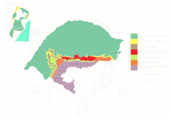
Figure 1 Simplified geological map of Paraná Basin in Rio Grande do Sul state, Brazil. (modified from Scherer & Lavina)[3]
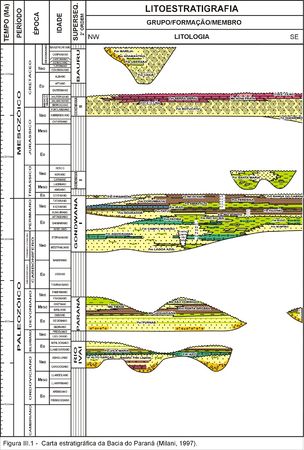
Figure 2 Stratigraphic diagram of Paraná Basin. Fm. Taquarembó is the Guará Formation correlate in Uruguay[4]


The Guará Formation is exposed in western Rio Grande do Sul, Brazil, bounded on the northeast by a fault system northwest–southeast (Figure 1); it extends to the north of Uruguay, where it is named as Batoví Member of Taquarembó Formation; and possibly to the east in Argentina, where is poorly known. In Rio Grande do Sul, it has discordant contacts with the overlying Botucatu Formation (Lower Cretaceous), and underlying Sanga do Cabral Formation (Lower Triassic; Figure 2).
Age[edit]
The Guará Formation is part of the Mesozoic fill of the Paraná Basin included in Supersequence Gondwana III[5] (Figure 2). In Brazil there is no evidence of fossils that enable dating; however, its correlated unit in Uruguayan territory (Batoví Member) has a diversified fossil content, represented by gastropods, crocodilian reptiles, fish and semionotiformes conchostracans,[6][7] which allow us to assign to the Guará Formation an age between Late Jurassic and Early Cretaceous.
Sedimentary Environments[edit]
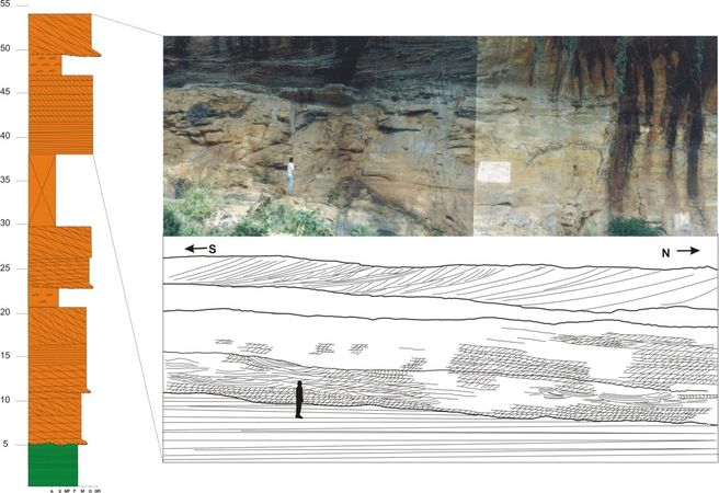
Figure 3 Vertical log and section showing the fluvial facies of Guará Formation northern portion.
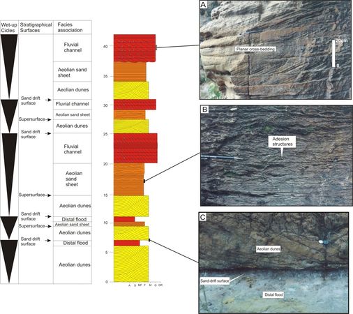
Figure 4 Vertical log of Guará Formation near the Brazil-Uruguay frontier, showing facies examples for the fluvio-eolian system.
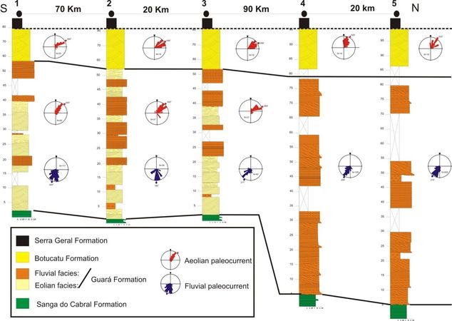
Figure 5 Stratigraphic correlation of Botucatu and Guará Formation in western Rio Grande do Sul (Brazil). Note the absence of aeolian facies in the northern portion of Guará Formation.[8]


The Guará Formation is described as fine to conglomeratic sandstones of whitish to reddish color, with trough cross stratification from small to large size and horizontal lamination. The facies associations characterize fluvial to fluvio-eolian deposits, with a distinctive change in facies throughout its exposure: the northern part consists in facies associations of braided fluvial systems (Figure 3); in the southern part, there is a tendency to replace the predominance of fluvial facies to aeolian associations (Figures 4 and 5).
References[edit]
- ↑ Lavina, E. L., 1991, Geologia sedimentar e paleogeografia do Neopermiano e Eotriássico (intervalo Kazaniano-Scitiano) da Bacia do Paraná: Curso de Pós-Graduação em Geociências, 336 p. Tese (Doutorado em Geociências) – Instituto de Geociências, Universidade Federal do Rio Grande do Sul.
- ↑ Lavina, E. L., and C. M. S. Scherer, 1997, Arquitetura estratigráfica da sedimentação Neopermiana e Mesozóica na região oeste do estado do Rio Grande do Sul: Implicações na construção do arcabouço estratigráfico da Bacia do Paraná. In: SIMP. CRONOESTRAT. BACIA DO PARANÁ, 3, Boletim de Resumos, p. 33-34.
- ↑ 3.0 3.1 Scherer, C. M. S., and E. L. Lavina, 2005, Sedimentary cycles and facies architecture of eolian-fluvial strata of the Late Jurassic–Early Cretaceous Guará Formation, Southern Brazil: Sedimentology, v. 52, p. 1323-1341.
- ↑ Milani, E. J., 1997, Evolução tectono-estratigráfica da Bacia do Paraná e seu relacionamento com a geodinâmica fanerozóica do Gondwana sul-ocidental: Unpublished Ph.D thesis, Universidade Federal do Rio Grande do Sul, Porto Alegre, 255p.
- ↑ Milani, E.J.; Faccini, U.F.; Scherer, C.M.S.; Araujo, L.M.; Cupertino, J.A. 1998. Sequence and stratigraphy hierarquy of the Paraná Basin (Ordovician to Cretaceous), Southern Brazil. Bol. IG USP, Série Científica, v. 29, p.125-173.
- ↑ Mones, A & Figueira, A. 1980. A geopaleontological synthesis of the Gondwana formations of Uruguay. In: CRESWELL, M.M. & VIELLA, P. (eds) Gondwana Rotterdam, A. A. Balkema, New York, p. 47-52.
- ↑ Ferrando, L.; Andreis, R.R.; Montana, J.R. 1987. Estratigrafia del Triásico – Jurásico uruguaio em la cuenca del Paraná. In: SIMP SUL-BRAS. GEOL., 3, Anais ..., v.1., p. 373-378.
- ↑ Scherer, C. M. S., and E. L. C. Lavina, 2006, Stratigraphic evolution of a fluvial-eolian succession: The example of the Upper Jurassic-Lower Cretaceous Guará and Botucatu formations, Paraná Basin, Southernmost Brazil: Gondwana Research, v. 9, no. 4, p. 475–484.