Difference between revisions of "Magnetotellurics survey measurements"
Cwhitehurst (talk | contribs) |
Cwhitehurst (talk | contribs) m (added Category:Treatise Handbook 3 using HotCat) |
||
| (9 intermediate revisions by 2 users not shown) | |||
| Line 6: | Line 6: | ||
| part = Predicting the occurrence of oil and gas traps | | part = Predicting the occurrence of oil and gas traps | ||
| chapter = Applying magnetotellurics | | chapter = Applying magnetotellurics | ||
| − | | frompg = 16- | + | | frompg = 16-5 |
| − | | topg = 16- | + | | topg = 16-5 |
| author = Arnie Ostrander | | author = Arnie Ostrander | ||
| link = http://archives.datapages.com/data/specpubs/beaumont/ch16/ch16.htm | | link = http://archives.datapages.com/data/specpubs/beaumont/ch16/ch16.htm | ||
| Line 29: | Line 29: | ||
==The E-field== | ==The E-field== | ||
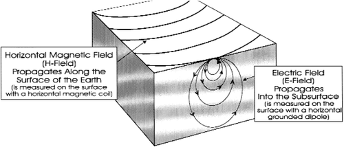
| − | [[file:applying-magnetotellurics_fig16-2.png|thumb|{{figure number|1}}]] | + | [[file:applying-magnetotellurics_fig16-2.png|thumb|500px|{{figure number|1}}Relationship between the E- and H-fields.]] |
The E-field is the secondary field, generated by the H-field propagating across the surface. Each time the primary H-field (an AC signal) switches polarity, a secondary E-field (current flow) is generated in the subsurface. Thus, the horizontal E-field data provides information about the subsurface geology. | The E-field is the secondary field, generated by the H-field propagating across the surface. Each time the primary H-field (an AC signal) switches polarity, a secondary E-field (current flow) is generated in the subsurface. Thus, the horizontal E-field data provides information about the subsurface geology. | ||
| Line 51: | Line 51: | ||
==See also== | ==See also== | ||
| − | * [[ | + | * [[Magnetotellurics]] |
| − | * [[ | + | * [[Magnetotelluric data acquisition]] |
| − | * [[ | + | * [[Magnetotellurics case history: frontier basin analysis (Amazon Basin, Colombia)]] |
| − | * [[ | + | * [[Magnetotellurics case history: rugged carbonate terrain (Highlands of Papua New Guinea)]] |
| − | * [[ | + | * [[Magnetotellurics case history: Precambrian overthrust (Northwestern Colorado)]] |
| − | * [[ | + | * [[Magnetotellurics case history: volcanic terrain (Columbia River Plateau)]] |
==External links== | ==External links== | ||
| Line 65: | Line 65: | ||
[[Category:Predicting the occurrence of oil and gas traps]] | [[Category:Predicting the occurrence of oil and gas traps]] | ||
[[Category:Applying magnetotellurics]] | [[Category:Applying magnetotellurics]] | ||
| + | [[Category:Treatise Handbook 3]] | ||
Latest revision as of 19:57, 27 January 2022
| Exploring for Oil and Gas Traps | |

| |
| Series | Treatise in Petroleum Geology |
|---|---|
| Part | Predicting the occurrence of oil and gas traps |
| Chapter | Applying magnetotellurics |
| Author | Arnie Ostrander |
| Link | Web page |
| Store | AAPG Store |
What is measured?[edit]
Two basic alternating current (AC) measurements are taken in an MT survey: a horizontal magnetic field (H-field) measurement and an electrical field (E-field) measurement. The E-field is always measured perpendicular to the H-field data.
The H-field[edit]
The H-field is the “source” signal, or the primary field. It propagates across the surface of the earth. Because it does not travel in the subsurface, the H-field data do not provide information about the subsurface geology.
Very limited information about the subsurface geology can be interpreted from the vertical H-field if this component is measured. The vertical H-field is called the tipper.
The horizontal H-field is measured with a horizontally oriented magnetic coil. The tipper is measured with a vertically oriented coil.
Be careful not to confuse an MT survey with a magnetic survey. An MT survey does not measure the magnetic properties of the subsurface rocks, as does a magnetic survey.
The E-field[edit]
The E-field is the secondary field, generated by the H-field propagating across the surface. Each time the primary H-field (an AC signal) switches polarity, a secondary E-field (current flow) is generated in the subsurface. Thus, the horizontal E-field data provides information about the subsurface geology.
This is the same physical principle as the alternator in a car. An alternating or spinning magnetic field (H-field) sets up current flow in the wire windings in the alternator, which in turn charges the battery. In the case of an MT survey, the “wire” is the earth.
The E-field is measured with a grounded dipole typically 50–200 m long. All subsurface geology information is contained in the E-field data. However, without the H-field data, we cannot calculate resistivity.
Figure 1 shows the relationship between the E- and H-fields.
Resistivity calculation[edit]
The resistivity calculation is a simple ratio of the primary source signal (H-field) and the secondary current flow in the earth (E-field), with a modifier for the frequency at which the data were acquired:
where:
- E = magnitude of the E-field
- H = magnitude of the H-field
- f = frequency
See also[edit]
- Magnetotellurics
- Magnetotelluric data acquisition
- Magnetotellurics case history: frontier basin analysis (Amazon Basin, Colombia)
- Magnetotellurics case history: rugged carbonate terrain (Highlands of Papua New Guinea)
- Magnetotellurics case history: Precambrian overthrust (Northwestern Colorado)
- Magnetotellurics case history: volcanic terrain (Columbia River Plateau)

