Difference between revisions of "Sediment thickness and field location maps: Gulf of Mexico example"
Cwhitehurst (talk | contribs) m (added Category:Treatise Handbook 3 using HotCat) |
|||
| (15 intermediate revisions by 3 users not shown) | |||
| Line 6: | Line 6: | ||
| part = Critical elements of the petroleum system | | part = Critical elements of the petroleum system | ||
| chapter = Sedimentary basin analysis | | chapter = Sedimentary basin analysis | ||
| − | | frompg = 4- | + | | frompg = 4-9 |
| − | | topg = 4- | + | | topg = 4-10 |
| author = John M. Armentrout | | author = John M. Armentrout | ||
| link = http://archives.datapages.com/data/specpubs/beaumont/ch04/ch04.htm | | link = http://archives.datapages.com/data/specpubs/beaumont/ch04/ch04.htm | ||
| Line 14: | Line 14: | ||
| isbn = 0-89181-602-X | | isbn = 0-89181-602-X | ||
}} | }} | ||
| + | |||
==Discussion== | ==Discussion== | ||
| − | + | <gallery mode=packed heights=200px widths=200px> | |
| − | + | Sedimentary-basin-analysis fig4-3.png|{{figure number|1}}Total Jurassic to Recent sediment thickness and hydrocarbon occurrences in the GOM basin. From Winker & Buffler;<ref name=WinkerandBuffler>Winker, C. D., and R. T. Buffler, 1988, [http://archives.datapages.com/data/bulletns/1988-89/data/pg/0072/0003/0300/0318.htm Paleogeographic evolution of the early deep-water Gulf of Mexico and its margins, Jurassic to middle Cretaceous (Comanchean)]: AAPG Bulletin, vol. 72, p. 318-346</ref> courtesy AAPG. | |
| − | + | Sedimentary-basin-analysis fig4-4.png|{{figure number|2}}Major sand influxes into the northern Gulf of Mexico from Late Cretaceous to Recent. After Winker.<ref name=ch04r114>Winker, D. C., Cenozoic shelf margins, northwestern Gulf of Mexico: Gulf Coast Association of Geological Societies Transactions, v. 32, p. 427-448.</ref> Courtesy Gulf Coast Association of Geological Societies. | |
| − | + | Sedimentary-basin-analysis fig4-5.png|{{figure number|3}}Map of hydrocarbon types ibased on analyses of more than 2000 oil, 600 gas, and 1200 seep samples correlated to specific source rocks. Modified from Gross et al.<ref name=Grossetal_1995>Gross, O. P., K. C. Hood, L. M. Wenger, and S. C. Harrison, 1995, Seismic imaging and analysis of source and migration within an integrated hydrocarbon system study, northern Gulf of Mexico basin: Abstracts, 1st Latin American Geophysical Conference, p. 1-4.</ref> | |
| − | + | </gallery> | |
| + | A map of the sediment thickness (isopach) and occurrence of hydrocarbons is an initial step in identifying the [[petroleum system]](s) of a basin. [[:file:Sedimentary-basin-analysis fig4-3.png|Figure 1]] shows the total Jurassic to Recent sediment thickness and hydrocarbon occurrences in the GOM basin. The hydrocarbon occurrences are concentrated in reservoir rocks that range in age from Jurassic to Pleistocene along the northern margin of the basin in the area over [[transitional crust]] and thick salt accumulations. Identification of specific sub basinal [[depocenter]]s within the area of hydrocarbon occurrences is shown in [[:file:Sedimentary-basin-analysis fig4-4.png|Figure 2]]. Hydrocarbon types reflect the composition of the kerogens from which they were generated and provide an estimate of the potential number of [[source rock]]s within the area (see [[:file:Sedimentary-basin-analysis fig4-5.png|Figure 3]]). | ||
| − | |||
==Map of major sand influxes== | ==Map of major sand influxes== | ||
| − | Major influxes of sand into the northern GOM margin have shifted laterally from the Late Cretaceous to Recent.<ref name=ch04r114>Winker, C., D., 1982, Cenozoic shelf margins, northwestern Gulf of Mexico: Gulf Coast Assoc. of Geological Societies Transactions, vol. 32, p. 427–448.</ref> Each of these depocenters is related to the progressive filling of the basin margin, shifting the accommodation space basinward. Accommodation space refers to the volume of space available for sediment accumulation—the space resulting from the interaction of tectonic subsidence or uplift, sea level change, and compaction of the underlying sediment. Additionally, the lateral shift of the fluvial systems is recorded by sand-prone facies that document both the primary input area and the lateral shift of the depocenter through time. | + | Major influxes of sand into the northern GOM margin have shifted laterally from the Late Cretaceous to Recent.<ref name=ch04r114>Winker, C., D., 1982, Cenozoic shelf margins, northwestern Gulf of Mexico: Gulf Coast Assoc. of Geological Societies Transactions, vol. 32, p. 427–448.</ref> Each of these depocenters is related to the progressive filling of the basin margin, shifting the accommodation space basinward. Accommodation space refers to the volume of space available for sediment accumulation—the space resulting from the interaction of tectonic subsidence or uplift, sea level change, and compaction of the underlying sediment. Additionally, the [[lateral]] shift of the fluvial systems is recorded by sand-prone facies that document both the primary input area and the lateral shift of the depocenter through time. |
| − | Many of these lateral shifts result from tectonic events along the basin margin or within the drainage basins themselves.<ref name=ch04r34>Galloway, W., E., 1989, [http://archives.datapages.com/data/bulletns/1988-89/data/pg/0073/0002/0100/0125.htm Genetic stratigraphic sequences in basin analysis I: architecture and genesis of flooding-surface bounded depositional units]: AAPG Bulletin, vol. 73, p. 125–142.</ref> The lateral shift of the fluvial-deltaic systems is also reflected in the lateral shift of the gravity-flow depositional systems on the slope and basin floor.<ref name=Feng_Buffler_1994>Feng, J., and R. T. Buffler, 1994, Turbidite systems and their temporal and spacial distribution, deep Gulf of Mexico Basin: Gulf Coast Section SEPM Foundation 15th Annual Research Conference Submarine Fans and Turbidite Systems, December 4-7, p. 115-125.</ref> | + | Many of these lateral shifts result from tectonic events along the basin margin or within the drainage basins themselves.<ref name=ch04r34>Galloway, W., E., 1989, [http://archives.datapages.com/data/bulletns/1988-89/data/pg/0073/0002/0100/0125.htm Genetic stratigraphic sequences in basin analysis I: architecture and genesis of flooding-surface bounded depositional units]: AAPG Bulletin, vol. 73, p. 125–142.</ref> The lateral shift of the fluvial-deltaic systems is also reflected in the lateral shift of the [[gravity]]-flow depositional systems on the slope and basin floor.<ref name=Feng_Buffler_1994>Feng, J., and R. T. Buffler, 1994, Turbidite systems and their temporal and spacial distribution, deep Gulf of Mexico Basin: Gulf Coast Section SEPM Foundation 15th Annual Research Conference Submarine Fans and Turbidite Systems, December 4-7, p. 115-125.</ref> |
| − | + | [[:file:Sedimentary-basin-analysis fig4-4.png|Figure 2]] shows major sand influxes into the northern [[Gulf of Mexico]] from Late Cretaceous to Recent. Each area of sand-prone sediment provides age-specific potential reservoirs within these fluvial-deltaic depositional systems. | |
==See also== | ==See also== | ||
| − | |||
* [[How to define the framework of a basin]] | * [[How to define the framework of a basin]] | ||
* [[Example: defining a basin outline]] | * [[Example: defining a basin outline]] | ||
| Line 46: | Line 46: | ||
[[Category:Critical elements of the petroleum system]] | [[Category:Critical elements of the petroleum system]] | ||
[[Category:Sedimentary basin analysis]] | [[Category:Sedimentary basin analysis]] | ||
| + | [[Category:Treatise Handbook 3]] | ||
Latest revision as of 19:58, 18 February 2022
| Exploring for Oil and Gas Traps | |

| |
| Series | Treatise in Petroleum Geology |
|---|---|
| Part | Critical elements of the petroleum system |
| Chapter | Sedimentary basin analysis |
| Author | John M. Armentrout |
| Link | Web page |
| Store | AAPG Store |
Discussion
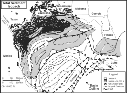
Figure 1 Total Jurassic to Recent sediment thickness and hydrocarbon occurrences in the GOM basin. From Winker & Buffler;[1] courtesy AAPG.
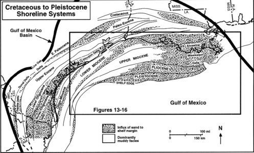
Figure 2 Major sand influxes into the northern Gulf of Mexico from Late Cretaceous to Recent. After Winker.[2] Courtesy Gulf Coast Association of Geological Societies.
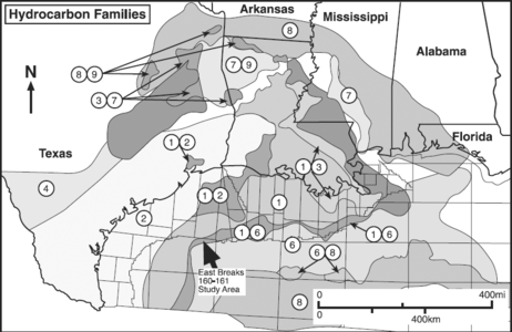
Figure 3 Map of hydrocarbon types ibased on analyses of more than 2000 oil, 600 gas, and 1200 seep samples correlated to specific source rocks. Modified from Gross et al.[3]


A map of the sediment thickness (isopach) and occurrence of hydrocarbons is an initial step in identifying the petroleum system(s) of a basin. Figure 1 shows the total Jurassic to Recent sediment thickness and hydrocarbon occurrences in the GOM basin. The hydrocarbon occurrences are concentrated in reservoir rocks that range in age from Jurassic to Pleistocene along the northern margin of the basin in the area over transitional crust and thick salt accumulations. Identification of specific sub basinal depocenters within the area of hydrocarbon occurrences is shown in Figure 2. Hydrocarbon types reflect the composition of the kerogens from which they were generated and provide an estimate of the potential number of source rocks within the area (see Figure 3).
Map of major sand influxes
Major influxes of sand into the northern GOM margin have shifted laterally from the Late Cretaceous to Recent.[2] Each of these depocenters is related to the progressive filling of the basin margin, shifting the accommodation space basinward. Accommodation space refers to the volume of space available for sediment accumulation—the space resulting from the interaction of tectonic subsidence or uplift, sea level change, and compaction of the underlying sediment. Additionally, the lateral shift of the fluvial systems is recorded by sand-prone facies that document both the primary input area and the lateral shift of the depocenter through time.
Many of these lateral shifts result from tectonic events along the basin margin or within the drainage basins themselves.[4] The lateral shift of the fluvial-deltaic systems is also reflected in the lateral shift of the gravity-flow depositional systems on the slope and basin floor.[5]
Figure 2 shows major sand influxes into the northern Gulf of Mexico from Late Cretaceous to Recent. Each area of sand-prone sediment provides age-specific potential reservoirs within these fluvial-deltaic depositional systems.
See also
- How to define the framework of a basin
- Example: defining a basin outline
- Example: mapping hydrocarbon types
References
- ↑ Winker, C. D., and R. T. Buffler, 1988, Paleogeographic evolution of the early deep-water Gulf of Mexico and its margins, Jurassic to middle Cretaceous (Comanchean): AAPG Bulletin, vol. 72, p. 318-346
- ↑ 2.0 2.1 Winker, D. C., Cenozoic shelf margins, northwestern Gulf of Mexico: Gulf Coast Association of Geological Societies Transactions, v. 32, p. 427-448. Cite error: Invalid
<ref>tag; name "ch04r114" defined multiple times with different content - ↑ Gross, O. P., K. C. Hood, L. M. Wenger, and S. C. Harrison, 1995, Seismic imaging and analysis of source and migration within an integrated hydrocarbon system study, northern Gulf of Mexico basin: Abstracts, 1st Latin American Geophysical Conference, p. 1-4.
- ↑ Galloway, W., E., 1989, Genetic stratigraphic sequences in basin analysis I: architecture and genesis of flooding-surface bounded depositional units: AAPG Bulletin, vol. 73, p. 125–142.
- ↑ Feng, J., and R. T. Buffler, 1994, Turbidite systems and their temporal and spacial distribution, deep Gulf of Mexico Basin: Gulf Coast Section SEPM Foundation 15th Annual Research Conference Submarine Fans and Turbidite Systems, December 4-7, p. 115-125.
External links
| find literature about Sediment thickness and field location maps: Gulf of Mexico example |