Difference between revisions of "Surficial geochemical case history 2: stratigraphic trap"
FWhitehurst (talk | contribs) m (FWhitehurst moved page Geochemical case history 2: stratigraphic trap to Surficial geochemical case history 2: stratigraphic trap: Misleading w/o 'surficial') |
Cwhitehurst (talk | contribs) |
||
| (14 intermediate revisions by 2 users not shown) | |||
| Line 1: | Line 1: | ||
| + | {{Merge|Surficial geochemical case histories}} | ||
{{publication | {{publication | ||
| image = exploring-for-oil-and-gas-traps.png | | image = exploring-for-oil-and-gas-traps.png | ||
| Line 6: | Line 7: | ||
| part = Predicting the occurrence of oil and gas traps | | part = Predicting the occurrence of oil and gas traps | ||
| chapter = Surface geochemical exploration for petroleum | | chapter = Surface geochemical exploration for petroleum | ||
| − | | frompg = 18- | + | | frompg = 18-22 |
| − | | topg = 18- | + | | topg = 18-22 |
| author = Dietmar Schumacher | | author = Dietmar Schumacher | ||
| link = http://archives.datapages.com/data/specpubs/beaumont/ch18/ch18.htm | | link = http://archives.datapages.com/data/specpubs/beaumont/ch18/ch18.htm | ||
| Line 14: | Line 15: | ||
| isbn = 0-89181-602-X | | isbn = 0-89181-602-X | ||
}} | }} | ||
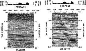
| − | In this case history, the client conducted a soil gas hydrocarbon survey along the trace of the seismic line to look for evidence of hydrocarbon microseepage from a seismically defined trap at CDP 1070 ([[:file:surface-geochemical-exploration-for-petroleum_fig18-6.png|Figure 1]]). Propane soil gas anomalies were detected at CDP 1070 and 1096. The wildcat well drilled at CDP 1070 resulted in a new field discovery. The geochemical lead at CDP 1096 was reevaluated seismically. After additional processing, a revised interpretation (right) also predicted [[porosity]] development there and coincident with the surface geochemical anomaly. A second productive well was drilled at CDP 1096. | + | In this case history, the client conducted a [[Surficial geochemistry and hydrocarbon detection methods|soil gas hydrocarbon survey]] along the [[trace]] of the [[seismic line]] to look for evidence of hydrocarbon [[Macroseepage vs. microseepage in surficial geochemistry|microseepage]] from a seismically defined [[trap]] at [[commom depth point (CDP)]] 1070 ([[:file:surface-geochemical-exploration-for-petroleum_fig18-6.png|Figure 1]]). [[Surficial geochemistry and hydrocarbon detection methods#Detection of light hydrocarbons|Propane soil gas]] anomalies were detected at CDP 1070 and 1096. The [[wildcat]] well drilled at CDP 1070 resulted in a new field discovery. The geochemical lead at CDP 1096 was reevaluated seismically. After additional [[Seismic processing basics|processing]], a revised interpretation (right) also predicted [[porosity]] development there and coincident with the surface geochemical anomaly. A second productive well was drilled at CDP 1096. |
| − | [[file:surface-geochemical-exploration-for-petroleum_fig18-6.png| | + | [[:file:surface-geochemical-exploration-for-petroleum_fig18-6.png|Figure 1]] is a [[seismic section]] and soil gas profile of a [[stratigraphic trap]] located at approximately [[depth::5,600 ft]] (1.5 sec) in the [[Cretaceous]] Escondido Sandstone in La Salle County, Texas. |
| − | + | [[file:surface-geochemical-exploration-for-petroleum_fig18-6.png|300px|thumb|left|{{figure number|1}}[[Seismic section]] and soil gas profile of a [[stratigraphic trap]] located at approximately 5,600 ft (1.5 sec) in the [[Cretaceous]] Escondido Sandstone in La Salle County, Texas. Modified. Copyright: Rice<ref name=Rice_1989>Rice, G., 1989, Exploration Enhancement by integrating near-surface geochemical and seismic methods: Oil & Gas Journal, v. 87, no. 14 (April 3), p. 66-71.</ref>; courtesy Oil & Gas Journal.]] | |
| − | + | {{clear}} | |
| − | |||
==See also== | ==See also== | ||
* [[Geochemical case histories]] | * [[Geochemical case histories]] | ||
| − | * [[ | + | * [[Surficial geochemical case history 1: structural traps]] |
| − | * [[ | + | * [[Surficial geochemical case history 3: Predrill–postdrill comparison]] |
| + | |||
| + | ==References== | ||
| + | {{reflist}} | ||
==External links== | ==External links== | ||
| Line 35: | Line 38: | ||
[[Category:Predicting the occurrence of oil and gas traps]] | [[Category:Predicting the occurrence of oil and gas traps]] | ||
[[Category:Surface geochemical exploration for petroleum]] | [[Category:Surface geochemical exploration for petroleum]] | ||
| + | [[Category:Treatise Handbook 3]] | ||
Latest revision as of 17:45, 12 April 2022
| It has been suggested that this article be merged with [[::Surficial geochemical case histories|Surficial geochemical case histories]]. (Discuss) |
| Exploring for Oil and Gas Traps | |

| |
| Series | Treatise in Petroleum Geology |
|---|---|
| Part | Predicting the occurrence of oil and gas traps |
| Chapter | Surface geochemical exploration for petroleum |
| Author | Dietmar Schumacher |
| Link | Web page |
| Store | AAPG Store |
In this case history, the client conducted a soil gas hydrocarbon survey along the trace of the seismic line to look for evidence of hydrocarbon microseepage from a seismically defined trap at commom depth point (CDP) 1070 (Figure 1). Propane soil gas anomalies were detected at CDP 1070 and 1096. The wildcat well drilled at CDP 1070 resulted in a new field discovery. The geochemical lead at CDP 1096 was reevaluated seismically. After additional processing, a revised interpretation (right) also predicted porosity development there and coincident with the surface geochemical anomaly. A second productive well was drilled at CDP 1096.
Figure 1 is a seismic section and soil gas profile of a stratigraphic trap located at approximately depth::5,600 ft (1.5 sec) in the Cretaceous Escondido Sandstone in La Salle County, Texas.

See also
- Geochemical case histories
- Surficial geochemical case history 1: structural traps
- Surficial geochemical case history 3: Predrill–postdrill comparison
References
- ↑ Rice, G., 1989, Exploration Enhancement by integrating near-surface geochemical and seismic methods: Oil & Gas Journal, v. 87, no. 14 (April 3), p. 66-71.