Difference between revisions of "Magnetotelluric survey case history: volcanic terrain (Columbia River Plateau)"
FWhitehurst (talk | contribs) |
FWhitehurst (talk | contribs) |
||
| Line 39: | Line 39: | ||
* [[Magnetotellurics survey measurements]] | * [[Magnetotellurics survey measurements]] | ||
* [[Magnetotelluric data acquisition]] | * [[Magnetotelluric data acquisition]] | ||
| − | * [[ | + | * [[Magnetotellurics case history: frontier basin analysis (Amazon Basin, Colombia)]] |
* [[Case history: rugged carbonate terrain (Highlands of Papua New Guinea)]] | * [[Case history: rugged carbonate terrain (Highlands of Papua New Guinea)]] | ||
* [[Case history: Precambrian overthrust (Northwestern Colorado)]] | * [[Case history: Precambrian overthrust (Northwestern Colorado)]] | ||
Revision as of 19:34, 19 May 2014
| Exploring for Oil and Gas Traps | |

| |
| Series | Treatise in Petroleum Geology |
|---|---|
| Part | Predicting the occurrence of oil and gas traps |
| Chapter | Applying magnetotellurics |
| Author | Arnie Ostrander |
| Link | Web page |
| Store | AAPG Store |
Seismic methods do not work well in areas covered by volcanics because of the dispersive nature of the volcanics and because of the decrease in acoustic velocity at the base of the volcanics.
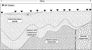
Volcanic terrain, however, is an ideal environment for MT because it is a simple, three-layer stratigraphic package: resistive basalts over conductive sediments, which in turn overlie resistive metamorphic or granitic basement rocks.
Survey results[edit]
Figure 1 is a 13-station MT natural source survey profile. This east-west section begins near the Idaho-Washington border and extends approximately length::75 mi (120 km) to the west (Mills, personal communication, 1994).
Structural details[edit]
These data provided the following structural details:
- Considerable variation on the thickness of the volcanics
- Considerable variation in the depth to top of basement
- Basalts thin to the east
- Sediments thin to east and eventually disappear
- Basement resistivities are an order-of-magnitude higher on the east end of the profile
Controlled-source MT data could provide 3-D imaging of individual prospects.
See also[edit]
- Magnetotellurics
- Magnetotellurics survey measurements
- Magnetotelluric data acquisition
- Magnetotellurics case history: frontier basin analysis (Amazon Basin, Colombia)
- Case history: rugged carbonate terrain (Highlands of Papua New Guinea)
- Case history: Precambrian overthrust (Northwestern Colorado)
References[edit]
- ↑ Mills, A., 1994, Zephyr Geophysical Services, personal communication.
