Search results
Jump to navigation
Jump to search
File:M115CH10FG05.jpg ...the Brae 2 and Brae 1 intervals, respectively. Modified from [[Kingfisher field|Turner and Connell (1991) and Spence and Kreutz (2003)]]. From AAPG Memoir(1,281 × 934 (1.29 MB)) - 18:44, 17 January 2019
File:M91FG186.JPG ...PG). From From Shepherd, M., 2009, Deltaic reservoirs, in M. Shepherd, Oil field production geology: AAPG Memoir 91, p. 279-288.(800 × 1,137 (157 KB)) - 19:22, 13 August 2015
File:Evaluating-structurally-complex-reservoirs fig1.png ...the complex structure seen in the discovery well of the Rail Road Gap oil field, California. The five plot types are (from left to right) azimuth versus de(1,933 × 1,167 (174 KB)) - 18:47, 14 January 2014
File:M91Ch06FG44.JPG ...f depletion. From Shepherd, M., 2009, Sources of data, in M. Shepherd, Oil field production geology: AAPG Memoir 91, p. 49-63.(800 × 696 (58 KB)) - 17:11, 3 June 2015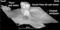
File:Mth14ch04f04.jpg ...nd Conclusions of a Horizontal-drilling Program at South Pass 62 Salt-dome Field, by E. P. Mason, M. J. Bastian, R. Detomo, M. N. Hashem, and A. J. Hildebra(400 × 202 (17 KB)) - 16:51, 7 December 2015
File:M106Ch12Table4.jpg ..., argillaceous limestone (arg limestone), shale, marl, and evaporite-marl. Field number refers to locations shown in Figure 3 of [[Iraq petroleum geology]].(700 × 438 (80 KB)) - 15:41, 12 May 2016
File:M106Ch12Table4a.jpg ..., argillaceous limestone (arg limestone), shale, marl, and evaporite-marl. Field number refers to locations shown in Figure 3 of [[Iraq petroleum geology]].(700 × 891 (157 KB)) - 15:41, 12 May 2016
File:M106Ch12Table4c.jpg ..., argillaceous limestone (arg limestone), shale, marl, and evaporite-marl. Field number refers to locations shown in Figure 3 of [[Iraq petroleum geology]].(700 × 906 (160 KB)) - 15:42, 12 May 2016
File:M106Ch12Table4d.jpg ..., argillaceous limestone (arg limestone), shale, marl, and evaporite-marl. Field number refers to locations shown in Figure 3 of [[Iraq petroleum geology]].(700 × 423 (78 KB)) - 15:42, 12 May 2016
File:M106Ch12Table4b.jpg ..., argillaceous limestone (arg limestone), shale, marl, and evaporite-marl. Field number refers to locations shown in Figure 3 of [[Iraq petroleum geology]].(700 × 888 (149 KB)) - 15:41, 12 May 2016
File:M91Ch13FG93.JPG ...ology. Shepherd, M., 2009, Structural geology: Faults, in M. Shepherd, Oil field production geology: AAPG Memoir 91, p. 107-122.(600 × 704 (72 KB)) - 21:40, 29 April 2015
File:Mth14ch07f04.jpg ...ique Horizontal-well Designs Boost Primary and EOR Production, Prudhoe Bay Field, Alaska , by R. S. Tye, B. A. Watson, P. L. McGuire, and M. M. Maguire, Pag(500 × 258 (39 KB)) - 17:58, 7 December 2015
File:M91Ch13FG88.JPG .... From Shepherd, M., 2009, Structural geology: Faults, in M. Shepherd, Oil field production geology: AAPG Memoir 91, p. 107-122.(600 × 585 (272 KB)) - 21:36, 29 April 2015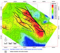
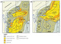
File:M115CH10FG02.jpg ...are in 100 ft (30 m) TVD increments. Area of map is shown in [[Kingfisher field|Figure 1]]. From AAPG Memoir 115—Rift-Related Coarse-Grained Submarine Fa(1,283 × 1,132 (1.55 MB)) - 18:38, 17 January 2019
File:Mth14ch02f06.jpg ...Turbidite Reservoir--The ARCO-DOE 91X-3 Horizontal Well Project, Yowlumne Field, San Joaquin Basin, California in AAPG Methods in Exploration No. 14: Horiz(700 × 481 (51 KB)) - 17:48, 4 December 2015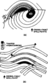
File:Evaluating-structurally-complex-reservoirs fig7.png Fault plane section and structure map of a model field to show the effects of synclinal and cross fault spilling. (a) Simple antic(861 × 1,502 (31 KB)) - 18:47, 14 January 2014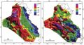
File:M106Ch12Fig02.jpg Bouguer gravity (right) and total magnetic field (left) maps of Iraq, from Jassim and Goff (2006), compiled by GEOSURV. The(700 × 373 (52 KB)) - 20:26, 11 May 2016
File:Mth14ch02f04.jpg ...Turbidite Reservoir--The ARCO-DOE 91X-3 Horizontal Well Project, Yowlumne Field, San Joaquin Basin, California in AAPG Methods in Exploration No. 14: Horiz(500 × 605 (114 KB)) - 15:58, 4 December 2015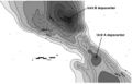
File:Mth14ch02f07.jpg ...Turbidite Reservoir--The ARCO-DOE 91X-3 Horizontal Well Project, Yowlumne Field, San Joaquin Basin, California in AAPG Methods in Exploration No. 14: Horiz(700 × 449 (53 KB)) - 19:56, 4 December 2015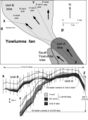
File:Mth14ch02f05.jpg ...Turbidite Reservoir--The ARCO-DOE 91X-3 Horizontal Well Project, Yowlumne Field, San Joaquin Basin, California in AAPG Methods in Exploration No. 14: Horiz(500 × 682 (64 KB)) - 17:07, 4 December 2015


