Difference between revisions of "Iraq petroleum geology"
(Created page with "{{publication | image = M106_cover_proof.jpg | series = AAPG Memoir | title = Petroleum systems of the Tethyan region | part = | chapter = Iraq | frompg = 379...") |
|||
| Line 14: | Line 14: | ||
}} | }} | ||
| − | There are more than 100 oil and gas fields in Iraq, containing more than 137 billion barrels of recoverable oil and more than 106 TCF of recoverable gas. Of this large resource, about 25 billion barrels of oil and 11 TCF of gas have been produced | + | There are more than 100 oil and gas fields in Iraq, containing more than 137 billion barrels of recoverable oil and more than 106 TCF of recoverable gas. Of this large resource, about 25 billion barrels of oil and 11 TCF of gas have been produced as of 2014. |
==Introduction== | ==Introduction== | ||
| Line 27: | Line 27: | ||
==Physiography== | ==Physiography== | ||
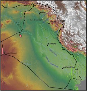
The southern and western parts of Iraq are part of the broader Arabian platform of adjacent Syria, Jordan, Saudi Arabia, and Kuwait ([[:file:M106Ch12Fig01.jpg|Figure 1]]). This is a sparsely populated area of desert and low hills, mostly 300–500 m (984–1640 ft) above sea level (msl). The highest elevation here occurs at Jabal ‘Unayzah, in the southwestern corner of the country, at 940 msl. Bedrock is exposed in these areas, largely Cenozoic but Mesozoic and Paleozoic in western Iraq. | The southern and western parts of Iraq are part of the broader Arabian platform of adjacent Syria, Jordan, Saudi Arabia, and Kuwait ([[:file:M106Ch12Fig01.jpg|Figure 1]]). This is a sparsely populated area of desert and low hills, mostly 300–500 m (984–1640 ft) above sea level (msl). The highest elevation here occurs at Jabal ‘Unayzah, in the southwestern corner of the country, at 940 msl. Bedrock is exposed in these areas, largely Cenozoic but Mesozoic and Paleozoic in western Iraq. | ||
| + | |||
| + | The land slopes down to the floodplains of the Al Furat (Euphrates) and Dijlah (Tigris) Rivers, which flow from Turkey and Syria through the length of Iraq to the Gulf of Arabia via the Shatt al Arab. The elevation at the Iraq–Syria border is 300–400 msl. Al Furat follows the Anah Graben until it reaches the subsiding Mesopotamian foredeep ([[:file:M106Ch12Fig01.jpg|Figure 1]]). The Dijlah flows around the uplifted Sinjar Graben to flow across the low portion of the Zagros foldbelt to the Mesopotamian foredeep. The floodplains are covered by alluvium, terrace gravels, and eolian sands. There are many towns and cities, including Baghdad, An Nasiriyah, and Basrah, in the floodplains of these rivers. | ||
| + | |||
| + | Elevations rise in northeastern Iraq. Most of the Kirkuk embayment of the Zagros foldbelt is covered by Neogene sediments, except for elongated northwest-trending anticlines that expose older strata. Surface elevations rise up to 850 m (2788 ft) on the Qara Chauq Dagh anticline ([[:file:M106Ch12Fig01.jpg|Figure 1]]). There are many towns and cities in this region, including Mosul and Kirkuk. | ||
| + | |||
| + | The High Zagros Nappe zone further to the northeast is characterized by large anticlinal mountains that expose Cenozoic to Paleozoic sediments as well as igneous and metamorphic rocks. Elevations are higher across this region, reaching 3586 m (11765 ft) on the Iraq-Iran border east of Rowandaz (Figure 1). Major gorges cut by rivers, such as the Zab River that runs into the Dijlah River near Jabal Qara Chauq Dagh, form exposures that are the type sections for many formations. | ||
| + | One effect of the surface relief of Iraq is the flow of groundwater deeply within the sediments of the Mesopotamian foredeep, from the somewhat higher Arabian platform in western and southern Iraq, as well as within synclines in the Kirkuk embayment of the Zagros foldbelt. Freshwater extends far into the subsurface because of these flows. | ||
| + | |||
| + | [[file:M106Ch12Fig02.jpg|thumb|300px|{{figure number|2}}Bouguer gravity (right) and total magnetic field (left) maps of Iraq, from Jassim and Goff,<ref name=Jassimandgoff_2006>Jassim, S. Z. and Goff, J. C., 2006, Geology of Iraq: Dolin, Prague, and Moravian Museum, Brno, 341 p.</ref> compiled by GEOSURV. The gravity map shows low values in the Zagros foldbelt and Mesopotamian foredeep due to the thick sedimentary section. Orientations of features trend to the north and northwest in southern, western, and northwestern Iraq, interpreted in part to be caused by the structural grain of Precambrian accreted terrains. 200 km (124.3 mi).]] | ||
| + | |||
| + | ==Tectonic setting== | ||
| + | |||
| + | |||
| + | |||
Revision as of 20:28, 11 May 2016
| Petroleum systems of the Tethyan region | |

| |
| Series | AAPG Memoir |
|---|---|
| Chapter | Iraq |
| Author | George J. Grabowski Jr. |
| Link | Web page |
| Store | AAPG Store |
There are more than 100 oil and gas fields in Iraq, containing more than 137 billion barrels of recoverable oil and more than 106 TCF of recoverable gas. Of this large resource, about 25 billion barrels of oil and 11 TCF of gas have been produced as of 2014.
Introduction
Nearly all of the oil and gas occurs in fields located within the Mesopotamian foredeep, Gotnia Basin, and Zagros foldbelt. Minor discoveries and shows have been found on the Arabian platform along the western flank of the Mesopotamian foredeep. There is one gas discovery (Akkas field) on the Arabian platform in western Iraq.
Ninety-eight percent of the oil and gas occurs in reservoirs of Cenozoic and Cretaceous age. The largest reserves occur in: 1) carbonate rocks of the Kirkuk Group (Lower Miocene–Oligocene), in fields within the Zagros foldbelt of northeastern Iraq, the largest being Kirkuk field; 2) carbonate rocks of the Mishrif Formation (Turonian–Cenomanian), in fields within the Mesopotamian foredeep and Zagros foldbelt in southern and central Iraq, including Rumaila, West Qurna, Majnoon, Halfayah, Zubair, and Buzurgan fields; and 3) siliciclastic rocks of the Zubair Formation (Albian–Barremian), in fields within the Mesopotamian foredeep and Zagros foldbelt in southern and central Iraq, including East Baghdad, Rumaila, West Qurna, and Zubair fields. Large reserves also occur in carbonate rocks of the Upper Cretaceous above the Mishrif Formation and in the Lower Cretaceous below the Zubair Formation. Smaller reserves occur in other Neogene and Paleogene carbonates and siliciclastics, in Jurassic and Triassic carbonates, and in Ordovician siliciclastics.
Most of the oil and gas that have been discovered were generated from organic-rich, oil-prone carbonates of the Jurassic Sargelu and Naokelekan Formations. These source rocks are widely distributed and mature for oil and gas generation across the Mesopotamian foredeep and Zagros foldbelt. Lesser amounts of oil and gas are derived from: 1) Upper and Lower Cretaceous oil-prone source rocks within the Zagros foldbelt; 2) Triassic oil-prone source rocks in northwestern Iraq; and 3) Silurian gas-prone source rocks in western Iraq. The oil generated from the Jurassic source rocks migrated vertically to fill stacked reservoir intervals in many fields. Lateral migration of oil occurred along the western margin of the Mesopotamian foredeep, as proven by small fields and large seeps that are located where source rocks are absent or immature for oil or gas generation.
Physiography
The southern and western parts of Iraq are part of the broader Arabian platform of adjacent Syria, Jordan, Saudi Arabia, and Kuwait (Figure 1). This is a sparsely populated area of desert and low hills, mostly 300–500 m (984–1640 ft) above sea level (msl). The highest elevation here occurs at Jabal ‘Unayzah, in the southwestern corner of the country, at 940 msl. Bedrock is exposed in these areas, largely Cenozoic but Mesozoic and Paleozoic in western Iraq.
The land slopes down to the floodplains of the Al Furat (Euphrates) and Dijlah (Tigris) Rivers, which flow from Turkey and Syria through the length of Iraq to the Gulf of Arabia via the Shatt al Arab. The elevation at the Iraq–Syria border is 300–400 msl. Al Furat follows the Anah Graben until it reaches the subsiding Mesopotamian foredeep (Figure 1). The Dijlah flows around the uplifted Sinjar Graben to flow across the low portion of the Zagros foldbelt to the Mesopotamian foredeep. The floodplains are covered by alluvium, terrace gravels, and eolian sands. There are many towns and cities, including Baghdad, An Nasiriyah, and Basrah, in the floodplains of these rivers.
Elevations rise in northeastern Iraq. Most of the Kirkuk embayment of the Zagros foldbelt is covered by Neogene sediments, except for elongated northwest-trending anticlines that expose older strata. Surface elevations rise up to 850 m (2788 ft) on the Qara Chauq Dagh anticline (Figure 1). There are many towns and cities in this region, including Mosul and Kirkuk.
The High Zagros Nappe zone further to the northeast is characterized by large anticlinal mountains that expose Cenozoic to Paleozoic sediments as well as igneous and metamorphic rocks. Elevations are higher across this region, reaching 3586 m (11765 ft) on the Iraq-Iran border east of Rowandaz (Figure 1). Major gorges cut by rivers, such as the Zab River that runs into the Dijlah River near Jabal Qara Chauq Dagh, form exposures that are the type sections for many formations. One effect of the surface relief of Iraq is the flow of groundwater deeply within the sediments of the Mesopotamian foredeep, from the somewhat higher Arabian platform in western and southern Iraq, as well as within synclines in the Kirkuk embayment of the Zagros foldbelt. Freshwater extends far into the subsurface because of these flows.

Tectonic setting
See also
- Phanerozoic Tethys region
- Israel petroleum systems
- Libya hydrocarbon provinces
- Tethys region
- Jordan petroleum geology
References
- ↑ Jassim, S. Z. and Goff, J. C., 2006, Geology of Iraq: Dolin, Prague, and Moravian Museum, Brno, 341 p.
