Search results
Jump to navigation
Jump to search
File:M31F24.jpg ...ide gullies in the Mississippi River delta. The width of the mosaic is 1.5 km, and the superimposed grid is a 25-m square. The slope is from top (approxi(758 × 947 (524 KB)) - 18:21, 18 August 2014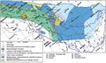
File:M106Ch14Fig11.jpg ...al highs close to the Mesopotamian depression area are also indicated. 100 km (62.1 mi). From M. L. Bordenave, 2014, Petroleum Systems and Distribution o(700 × 422 (79 KB)) - 18:36, 12 July 2016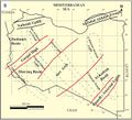
File:M106Ch04Fig2B.jpg ...s: Klitzsch (1971), Zegaar (1986), Anketell (1996), and Hallett (2002) 500 km (310.7 mi). From Hassan, H. S., and C. C. G. Kendall, 2014, Hydrocarbon pro(700 × 635 (73 KB)) - 19:43, 28 March 2016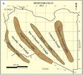
File:M106Ch04Fig2A.jpg ...s: Klitzsch (1971), Zegaar (1986), Anketell (1996), and Hallett (2002) 500 km (310.7 mi). From Hassan, H. S., and C. C. G. Kendall, 2014, Hydrocarbon pro(700 × 633 (66 KB)) - 19:44, 28 March 2016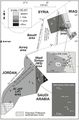
File:M106Ch07Fig04.jpg ...adjusted according to offset shale baseline. From Lüning et al. (2006). 5 km (3.1 mi). From Lüning et al. (2006). From Luning, S., and J. Kuss, 2014, P(564 × 855 (75 KB)) - 20:49, 18 April 2016- We can also convert distances like [[distance::25 km]] and depths like [[depth::12000 ft]].571 bytes (74 words) - 18:30, 8 August 2013
File:M106Ch12Fig02.jpg ...to be caused by the structural grain of Precambrian accreted terrains. 200 km (124.3 mi). From Grabowski Jr., G. J., 2014, Iraq, in L. Marlow, C. Kendall(700 × 373 (52 KB)) - 20:26, 11 May 2016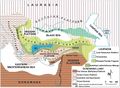
File:M106Ch13Fig01.jpg ...y an ophiolitic suite of rocks (redrawn from Şengör and Yilmaz, 1981). 300 km (186.4 mi). From Derman, Ahmet Sami, 2014, Petroleum systems of Turkish Bas(700 × 513 (90 KB)) - 19:29, 5 July 2016- ...he base of the [[crust]] to the core-mantle boundary at approximately 2900 km (-1802 mi) in depth.<ref name=Petersetal_2012>Peters, Kenneth E., David J.898 bytes (129 words) - 13:23, 3 August 2016
File:Mth14ch04f01.jpg South Pass 62 field is located 50 km southeast of the mouth of the Mississippi River in 100 m of water. Dark gra(700 × 525 (111 KB)) - 16:00, 7 December 2015- | 0 km<sup>2</sup> | 50 km<sup>2</sup>6 KB (834 words) - 20:41, 14 February 2022
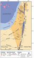
File:M106Ch06Fig02.jpg ...Numbers refer to oil fields and hydrocarbon shows detailed in Table 1. 50 km (31.1 mi). From Gardosh, Michael A., and Eli Tannenbaum, 2014, The petroleu(489 × 824 (63 KB)) - 15:25, 23 February 2016- ...ts, p. 428–499.</ref> This study area was very large approximately 300,000 km<sup>2</sup> (115,000 mi<sup>2</sup>) and remote with dense jungle cover, ru ...ompact. Data were collected from 43 sites, with a typical spacing of 10–20 km (6–12 mi).4 KB (480 words) - 15:12, 31 January 2022
File:M106Ch14Fig13.jpg ...abia), and migration paths from the kitchens toward the Gavbendi High. 100 km (62.1 mi). From M. L. Bordenave, 2014, Petroleum Systems and Distribution o(700 × 464 (101 KB)) - 18:44, 12 July 2016- ...ing fluids. Worldwide average geothermal gradients are from 24 to 41°C/km (1.3-2.2°F/100 ft), with extremes outside this range.<ref name=Peterset901 bytes (127 words) - 19:53, 25 June 2015
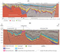
File:M114CH03FG03.jpg ...n the southern part of the basin are at burial depths present day of ca. 3 km and have not been significantly inverted. The large, deep fault northwest o(700 × 600 (112 KB)) - 17:49, 4 January 2019- ...dicity to the shear zones, the spacing between them varying from about 4–8 km (2.5–5 mi). ...out [[length::1 km]] (LaBerge, personal communication) up to [[length::2.5 km]] or more.5 KB (617 words) - 19:55, 27 January 2022
- ...n in a new basin, i.e., in determining whether it is 2, 5, or [[length::10 km]] thick, for example, to a usual accuracy of about ±15% under favorable co ...tion is approximately 3.6 km (12,000 ft) thick and basement lies about 3.8 km (12,500 ft) beneath flight level.]]8 KB (1,109 words) - 17:41, 24 January 2022
- ...[vitrinite reflectance]], right figure) and follow across at [[length::2.1 km]] until you reach the maturity profile. This vitrinite reflectance value (04 KB (503 words) - 14:18, 14 February 2022
- ...this, at about the level indicated by the arrows, the section crosses a 1-km-wide Paleocene deep-water [[turbidite]] channel. ...tracted where the shifted surface intersects the 3-D volume of data. The 1-km-wide channel is unmistakable on this view of the data, and both edges of th4 KB (617 words) - 19:30, 27 January 2022


