Search results
Jump to navigation
Jump to search
File:M106Ch04Fig2B.jpg ...s: Klitzsch (1971), Zegaar (1986), Anketell (1996), and Hallett (2002) 500 km (310.7 mi). From Hassan, H. S., and C. C. G. Kendall, 2014, Hydrocarbon pro(700 × 635 (73 KB)) - 19:43, 28 March 2016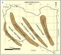
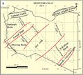
File:M106Ch04Fig2A.jpg ...s: Klitzsch (1971), Zegaar (1986), Anketell (1996), and Hallett (2002) 500 km (310.7 mi). From Hassan, H. S., and C. C. G. Kendall, 2014, Hydrocarbon pro(700 × 633 (66 KB)) - 19:44, 28 March 2016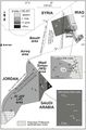
File:M106Ch07Fig04.jpg ...adjusted according to offset shale baseline. From Lüning et al. (2006). 5 km (3.1 mi). From Lüning et al. (2006). From Luning, S., and J. Kuss, 2014, P(564 × 855 (75 KB)) - 20:49, 18 April 2016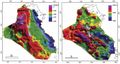
File:M106Ch12Fig02.jpg ...to be caused by the structural grain of Precambrian accreted terrains. 200 km (124.3 mi). From Grabowski Jr., G. J., 2014, Iraq, in L. Marlow, C. Kendall(700 × 373 (52 KB)) - 20:26, 11 May 2016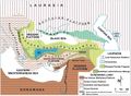
File:M106Ch13Fig01.jpg ...y an ophiolitic suite of rocks (redrawn from Şengör and Yilmaz, 1981). 300 km (186.4 mi). From Derman, Ahmet Sami, 2014, Petroleum systems of Turkish Bas(700 × 513 (90 KB)) - 19:29, 5 July 2016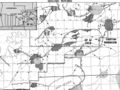
File:Mth14ch04f01.jpg South Pass 62 field is located 50 km southeast of the mouth of the Mississippi River in 100 m of water. Dark gra(700 × 525 (111 KB)) - 16:00, 7 December 2015
File:M106Ch06Fig02.jpg ...Numbers refer to oil fields and hydrocarbon shows detailed in Table 1. 50 km (31.1 mi). From Gardosh, Michael A., and Eli Tannenbaum, 2014, The petroleu(489 × 824 (63 KB)) - 15:25, 23 February 2016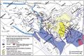
File:M106Ch14Fig13.jpg ...abia), and migration paths from the kitchens toward the Gavbendi High. 100 km (62.1 mi). From M. L. Bordenave, 2014, Petroleum Systems and Distribution o(700 × 464 (101 KB)) - 18:44, 12 July 2016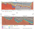
File:M114CH03FG03.jpg ...n the southern part of the basin are at burial depths present day of ca. 3 km and have not been significantly inverted. The large, deep fault northwest o(700 × 600 (112 KB)) - 17:49, 4 January 2019


