Search results
Jump to navigation
Jump to search
- ...cally occurs approximately 35 km (~19 mi) below the continents and 5 to 10 km (3-5 mi) below the floor of the ocean.<ref name=Petersetal_2012>Peters, Ken729 bytes (103 words) - 15:49, 4 December 2015
- ...onian sediments in the Ainsa Basin<ref>Dreyer et al</ref>. It contains 5.5 km of continuous outcrop exposure from the shelf-edge delta to the distal slop ...he south of the town of Ainsa, Huesca, Spain. It is about 25 km wide by 75 km long, and is bound on the east by the Rio Cinca, and the west by the Colina1 KB (163 words) - 00:12, 30 June 2014
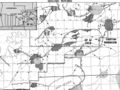
File:BlackWarriorBasinFG1.JPG Black Warrior Basin. 20 mi (32 km). From Fritz et al., 2012, Great American Carbonate Bank: Knox Group in the(800 × 563 (178 KB)) - 15:47, 5 January 2015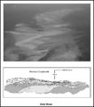
File:M91FG196.JPG Ooid shoal, Bahamas; the bottom edge of the photograph represents a 4.5-km (2.7 mi)-wide transect. The lower inset is an illustration of a cliff expos(800 × 909 (88 KB)) - 13:08, 20 August 2015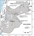
File:M106Ch07Fig07.jpg ...w of hydrocarbon shows in Jordanian petroleum wells. After NRA (2001). 100 km (62.1 mi). From Luning, S., and J. Kuss, 2014, Petroleum geology of Jordan,(700 × 735 (86 KB)) - 21:41, 18 April 2016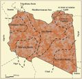
File:M106Ch04Fig03.jpg Sedimentary basins of Libya (productive basins, future prospective) 200 km (124.3 mi). From Hassan, H. S., and C. C. G. Kendall, 2014, Hydrocarbon pro(700 × 676 (77 KB)) - 20:13, 28 March 2016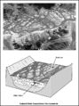
File:M91FG181.JPG ...llite photo of a braided river in Tibet. The braided river belt is about 7 km (4 mi) wide. Courtesy of the NASA Web site (www.earthobservatory.nasa.gov).(600 × 805 (104 KB)) - 21:18, 10 August 2015
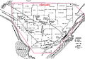
File:M106Ch07Fig1.jpg ...fields in Jordan. Modified after Beydoun et al. (1994) and NRA (2001). 100 km (62.1 mi). From Luning, S., and J. Kuss, 2014, Petroleum geology of Jordan,(700 × 857 (97 KB)) - 20:28, 18 April 2016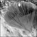
File:M91Ch11FG69.JPG ...ial fan in China's Xinjuang Province. The diameter of the fan is about 170 km (106 mi). Courtesy of the NASA Web site: www.earthasart.gsfc.nasa.gov. Show(600 × 606 (106 KB)) - 15:42, 27 April 2015
File:M106Ch13Fig11.jpg ...Adana and İskenderun subbasins (redrawn from Derman and Gürbüz, 2007). 10 km (6.2 mi). From Derman, Ahmet Sami, 2014, Petroleum systems of Turkish Basin(700 × 637 (109 KB)) - 20:03, 5 July 2016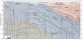
File:M106Ch12Fig06.jpg ...cross the Mesopotamian Foredeep to the Zagros foldbelt in eastern Iraq. 50 km (31.1 mi). From Grabowski Jr., G. J., 2014, Iraq, in L. Marlow, C. Kendall,(690 × 337 (55 KB)) - 13:59, 12 May 2016
File:M106h04Fig01.jpg ...ajor tectonic elements (modified after Rusk, 2001; Ramos et al., 2006) 500 km (310.7 mi). From Hassan, Hassan S. and Christopher C. G. Kendall, Hydrocarb(700 × 439 (50 KB)) - 19:01, 28 March 2016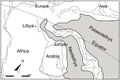
File:M106Ch07Fig05.jpg ...orthern Arabia and Northeast Africa. After Stampfli and Borel (2002). 1500 km (932 mi). From Lüning et al. (2006). From Luning, S., and J. Kuss, 2014, P(700 × 468 (49 KB)) - 21:06, 18 April 2016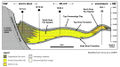
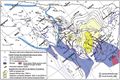
File:M115CH10FG03.jpg ...gh the Miller field area to the distal margin near the Kingfisher field 15 km (9 mi) to the northeast. Modified after [[Kingfisher field|Turner et al. (1(1,076 × 597 (435 KB)) - 18:42, 17 January 2019
File:M91FG186.JPG ...asart.gsfc.nasa.gov). The inset box on the photograph measures 34 times 42 km (21 times 26 mi). The lower diagram is a box diagram showing the sedimentol(800 × 1,137 (157 KB)) - 19:22, 13 August 2015
File:M91FG184.JPG ...f the NASA Web site (www.earthasart.gsfc.nasa.gov). The delta is about 200 km (124 mi) across in this view. The photograph has been rotated such that nor(800 × 1,134 (191 KB)) - 20:10, 12 August 2015
File:M106Ch14Fig01.jpg ...gure 2. Permian outcrops surrounding the Arabian shield are indicated. 200 km (124.3 mi). From M. L. Bordenave, 2014, Petroleum Systems and Distribution(641 × 662 (94 KB)) - 18:05, 12 July 2016
File:M106Ch14Fig12.jpg ...ndicating the regional highs as they appear before the Zagros folding. 100 km (62.1 mi). From M. L. Bordenave, 2014, Petroleum Systems and Distribution o(700 × 356 (74 KB)) - 19:40, 12 July 2016
File:M106Ch14Fig14.jpg ...al highs close to the Mesopotamian depression area are also indicated. 100 km (62.1 mi). From M. L. Bordenave, 2014, Petroleum Systems and Distribution o(700 × 402 (73 KB)) - 19:35, 12 July 2016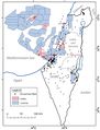
File:M106Ch06Fig03.jpg ...ormation in the Israel Ministry of Energy and Water Resources website). 50 km (31.1 mi). From Gardosh, Michael A., and Eli Tannenbaum, 2014, The petroleu(700 × 917 (76 KB)) - 15:29, 23 February 2016
File:M31F24.jpg ...ide gullies in the Mississippi River delta. The width of the mosaic is 1.5 km, and the superimposed grid is a 25-m square. The slope is from top (approxi(758 × 947 (524 KB)) - 18:21, 18 August 2014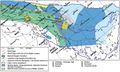
File:M106Ch14Fig11.jpg ...al highs close to the Mesopotamian depression area are also indicated. 100 km (62.1 mi). From M. L. Bordenave, 2014, Petroleum Systems and Distribution o(700 × 422 (79 KB)) - 18:36, 12 July 2016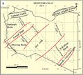
File:M106Ch04Fig2B.jpg ...s: Klitzsch (1971), Zegaar (1986), Anketell (1996), and Hallett (2002) 500 km (310.7 mi). From Hassan, H. S., and C. C. G. Kendall, 2014, Hydrocarbon pro(700 × 635 (73 KB)) - 19:43, 28 March 2016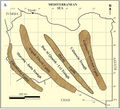
File:M106Ch04Fig2A.jpg ...s: Klitzsch (1971), Zegaar (1986), Anketell (1996), and Hallett (2002) 500 km (310.7 mi). From Hassan, H. S., and C. C. G. Kendall, 2014, Hydrocarbon pro(700 × 633 (66 KB)) - 19:44, 28 March 2016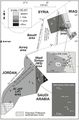
File:M106Ch07Fig04.jpg ...adjusted according to offset shale baseline. From Lüning et al. (2006). 5 km (3.1 mi). From Lüning et al. (2006). From Luning, S., and J. Kuss, 2014, P(564 × 855 (75 KB)) - 20:49, 18 April 2016- We can also convert distances like [[distance::25 km]] and depths like [[depth::12000 ft]].571 bytes (74 words) - 18:30, 8 August 2013
File:M106Ch12Fig02.jpg ...to be caused by the structural grain of Precambrian accreted terrains. 200 km (124.3 mi). From Grabowski Jr., G. J., 2014, Iraq, in L. Marlow, C. Kendall(700 × 373 (52 KB)) - 20:26, 11 May 2016
File:M106Ch13Fig01.jpg ...y an ophiolitic suite of rocks (redrawn from Şengör and Yilmaz, 1981). 300 km (186.4 mi). From Derman, Ahmet Sami, 2014, Petroleum systems of Turkish Bas(700 × 513 (90 KB)) - 19:29, 5 July 2016- ...he base of the [[crust]] to the core-mantle boundary at approximately 2900 km (-1802 mi) in depth.<ref name=Petersetal_2012>Peters, Kenneth E., David J.898 bytes (129 words) - 13:23, 3 August 2016
File:Mth14ch04f01.jpg South Pass 62 field is located 50 km southeast of the mouth of the Mississippi River in 100 m of water. Dark gra(700 × 525 (111 KB)) - 16:00, 7 December 2015- | 0 km<sup>2</sup> | 50 km<sup>2</sup>6 KB (834 words) - 20:41, 14 February 2022
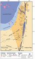
File:M106Ch06Fig02.jpg ...Numbers refer to oil fields and hydrocarbon shows detailed in Table 1. 50 km (31.1 mi). From Gardosh, Michael A., and Eli Tannenbaum, 2014, The petroleu(489 × 824 (63 KB)) - 15:25, 23 February 2016- ...ts, p. 428–499.</ref> This study area was very large approximately 300,000 km<sup>2</sup> (115,000 mi<sup>2</sup>) and remote with dense jungle cover, ru ...ompact. Data were collected from 43 sites, with a typical spacing of 10–20 km (6–12 mi).4 KB (480 words) - 15:12, 31 January 2022
File:M106Ch14Fig13.jpg ...abia), and migration paths from the kitchens toward the Gavbendi High. 100 km (62.1 mi). From M. L. Bordenave, 2014, Petroleum Systems and Distribution o(700 × 464 (101 KB)) - 18:44, 12 July 2016- ...ing fluids. Worldwide average geothermal gradients are from 24 to 41°C/km (1.3-2.2°F/100 ft), with extremes outside this range.<ref name=Peterset901 bytes (127 words) - 19:53, 25 June 2015
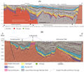
File:M114CH03FG03.jpg ...n the southern part of the basin are at burial depths present day of ca. 3 km and have not been significantly inverted. The large, deep fault northwest o(700 × 600 (112 KB)) - 17:49, 4 January 2019- ...dicity to the shear zones, the spacing between them varying from about 4–8 km (2.5–5 mi). ...out [[length::1 km]] (LaBerge, personal communication) up to [[length::2.5 km]] or more.5 KB (617 words) - 19:55, 27 January 2022
- ...n in a new basin, i.e., in determining whether it is 2, 5, or [[length::10 km]] thick, for example, to a usual accuracy of about ±15% under favorable co ...tion is approximately 3.6 km (12,000 ft) thick and basement lies about 3.8 km (12,500 ft) beneath flight level.]]8 KB (1,109 words) - 17:41, 24 January 2022
- ...[vitrinite reflectance]], right figure) and follow across at [[length::2.1 km]] until you reach the maturity profile. This vitrinite reflectance value (04 KB (503 words) - 14:18, 14 February 2022
- ...this, at about the level indicated by the arrows, the section crosses a 1-km-wide Paleocene deep-water [[turbidite]] channel. ...tracted where the shifted surface intersects the 3-D volume of data. The 1-km-wide channel is unmistakable on this view of the data, and both edges of th4 KB (617 words) - 19:30, 27 January 2022
- ...BasinFG1.JPG|thumb|300px|{{figure number|1}}Black Warrior Basin. 20 mi (32 km). From Fritz et al.<ref name=Fritzetal_2012>Fritz, R. D., P. Medlock, M. Ku2 KB (308 words) - 16:53, 26 March 2015
- ...llite photo of a braided river in Tibet. The braided river belt is about 7 km (4 mi) wide. Courtesy of the [http://www.earthobservatory.nasa.gov NASA Web ...dimentary Research, v. 76, p. 731–770.</ref> quoted widths in excess of 40 km (25 mi) and thicknesses up to 1200 m (3937 ft) for the very large braided r13 KB (1,859 words) - 21:29, 12 March 2019
- * SMW quantities, e.g. [[distance::145 km]]2 KB (300 words) - 15:57, 8 April 2014
- ===Major Plates (≥10 million km<sup>2</sup>)=== * Pacific Plate – 103,300,000 km<sup>2</sup>24 KB (3,689 words) - 17:46, 18 April 2019
- ...arrows). It also shows the interpreted limits of thick Jurassic salt (>1.5 km). The geographic shifts of primary fluvial input have resulted in [[depocen3 KB (370 words) - 17:53, 18 February 2022
- ...orner of New Mexico and in southern Colorado that encompasses about 35,000 km<sup>2</sup> (13,500 mi<sup>2</sup>). The [[basin]] contains deposits of [[n3 KB (411 words) - 15:01, 11 January 2016
- ...e Idaho-Washington border and extends approximately [[length::75 mi]] (120 km) to the west (Mills, personal communication, 1994).3 KB (359 words) - 15:15, 31 January 2022
- ...es in Jordan: Directorate of petroleum exploration, Amman, 56 p.</ref> 100 km (62.1 mi). ...shale baseline. From Lüning et al.<ref name=Lüningetal_2006 /> 5 km (3.1 mi).]]16 KB (2,310 words) - 15:13, 19 January 2017
- ...ew hundred acres to regional programs covering 1,000 mi<sup>2</sup> (2,590 km<sup>2</sup>).4 KB (499 words) - 22:30, 31 January 2022
- ...to investigating resistivities down to depths as great as 1 to [[length::2 km]], although greater depths of investigation are possible with some techniqu ...ounded wire systems are applicable to depths well in excess of [[length::1 km]], although high power transmitters are required as depth increases. The re15 KB (2,130 words) - 21:19, 19 January 2022


