Search results
Jump to navigation
Jump to search
Page title matches

File:Oil-field-production-geology.png (450 × 633 (553 KB)) - 18:24, 7 April 2014

Page text matches
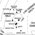
File:MainPageSorrentoField.png ...: Sorrento field; Petrophysical analysis of Sorrento field wells; Sorrento field: water saturation.(400 × 400 (43 KB)) - 17:53, 5 January 2015
File:BasinCenteredGasFig4.jpg ...Relief on top of overpressuring from outside the field area to inside the field area ranges from 2500 to 3000 ft (762-914 m) (Warner, 1998). Figure modifie(600 × 783 (79 KB)) - 22:22, 13 January 2015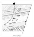
File:M91Figure165.JPG ...printed with permission from the Geological Society in AAPG Memoir 91, Oil field petroleum geology, by Mike Shepherd.(800 × 881 (128 KB)) - 20:28, 30 July 2014
File:M115CH10FG03.jpg ...ingfisher field 15 km (9 mi) to the northeast. Modified after [[Kingfisher field|Turner et al. (1987]]). From AAPG Memoir 115—Rift-Related Coarse-Grained(1,076 × 597 (435 KB)) - 18:42, 17 January 2019
File:M91Ch6FG42.JPG ...slow, 1999). From Shepherd, M., 2009, Sources of data, in M. Shepherd, Oil field production geology: AAPG Memoir 91, p. 49-63.(800 × 942 (95 KB)) - 17:04, 3 June 2015
File:M91Ch6FG47.JPG ...cal Society. From Shepherd, M., 2009, Sources of data, in M. Shepherd, Oil field production geology: AAPG Memoir 91, p. 49-63.(600 × 758 (111 KB)) - 21:46, 29 April 2015
File:M91Figure164.JPG ...h et al., 1998). Reprinted with permission from the AAPG in Memoir 91, Oil field petroleum geology, by Mike Shepherd.(800 × 483 (64 KB)) - 20:19, 30 July 2014
File:M91FG188.JPG ...amma ray. From Shepherd, M., 2009, Deltaic reservoirs, in M. Shepherd, Oil field production geology: AAPG Memoir 91, p. 279-288.(800 × 385 (54 KB)) - 16:21, 20 August 2015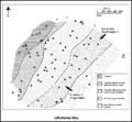
File:M91Ch11FG73.JPG ...al Society. From Shepherd, M., 2009, Lithofacies maps, in M. Shepherd, Oil field production geology: AAPG Memoir 91, p. 93-98.(800 × 738 (128 KB)) - 15:54, 27 April 2015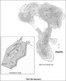
File:M91FG179.JPG ...rom Shepherd, M., 2009, Meandering fluvial reservoirs, in M. Shepherd, Oil field production geology: AAPG Memoir 91, p. 261-272.(800 × 984 (103 KB)) - 21:50, 3 August 2015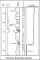
File:M91FG183.JPG .... From Shepherd, M., 2009, Braided fluvial reservoirs, in M. Shepherd, Oil field production geology: AAPG Memoir 91, p. 273-277.(800 × 1,199 (103 KB)) - 19:00, 12 August 2015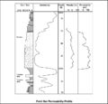
File:M91FG177.JPG ...rom Shepherd, M., 2009, Meandering fluvial reservoirs, in M. Shepherd, Oil field production geology: AAPG Memoir 91, p. 261-272.(800 × 765 (56 KB)) - 21:21, 3 August 2015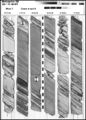
File:M91Ch6FG41.JPG ...y of London. From Shepherd, M., 2009, Sources of data, in M. Shepherd, Oil field production geology: AAPG Memoir 91, p. 49-63.(600 × 835 (138 KB)) - 17:00, 3 June 2015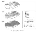
File:M91FG117.JPG ...forms are fairways for water ingress. Tidal mud flat deposits south of the field restrict water influx from this direction (from Tyler and Ambrose, 1986). R(800 × 689 (66 KB)) - 21:32, 12 August 2015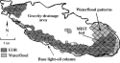
File:Mth14ch07f05.jpg ...ique Horizontal-well Designs Boost Primary and EOR Production, Prudhoe Bay Field, Alaska , by R. S. Tye, B. A. Watson, P. L. McGuire, and M. M. Maguire, Pag(500 × 264 (41 KB)) - 18:09, 7 December 2015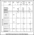
File:M91Ch6FG43.JPG ...further use. From Shepherd, M., 2009, Sources of data, in M. Shepherd, Oil field production geology: AAPG Memoir 91, p. 49-63.(800 × 827 (107 KB)) - 17:07, 3 June 2015
File:M115CH10FG04.jpg ...isher field. Also shown are the BP genetic sequences based on [[Kingfisher field|Partington et al. (1993)]]. From AAPG Memoir 115—Rift-Related Coarse-Grai(1,266 × 845 (845 KB)) - 18:43, 17 January 2019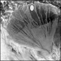
File:M91Ch11FG69.JPG ...oil field. From Shepherd, M., 2009, Lithofacies maps, in M. Shepherd, Oil field production geology: AAPG Memoir 91, p. 93-98.(600 × 606 (106 KB)) - 15:42, 27 April 2015
File:M91FG190.JPG ...the AAPG. From Shepherd, M., 2009, Deltaic reservoirs, in M. Shepherd, Oil field production geology: AAPG Memoir 91, p. 279-288.(800 × 1,047 (162 KB)) - 18:05, 20 August 2015
File:Mth14ch04f02.jpg ...nd Conclusions of a Horizontal-drilling Program at South Pass 62 Salt-dome Field, by E. P. Mason, M. J. Bastian, R. Detomo, M. N. Hashem, and A. J. Hildebra(500 × 718 (88 KB)) - 16:08, 7 December 2015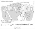
File:M91Ch11FG72.JPG ...= gamma-ray log. Shepherd, M., 2009, Lithofacies maps, in M. Shepherd, Oil field production geology: AAPG Memoir 91, p. 93-98.(800 × 658 (69 KB)) - 15:51, 27 April 2015
File:Mth14ch07f01.jpg ...ique Horizontal-well Designs Boost Primary and EOR Production, Prudhoe Bay Field, Alaska , by R. S. Tye, B. A. Watson, P. L. McGuire, and M. M. Maguire, Pag(700 × 809 (135 KB)) - 17:34, 7 December 2015
File:M91FG184.JPG ...rom AAPG. From Shepherd, M., 2009, Deltaic reservoirs, in M. Shepherd, Oil field production geology: AAPG Memoir 91, p. 279-288.(800 × 1,134 (191 KB)) - 20:10, 12 August 2015
File:M91Ch13FG92.JPG .... From Shepherd, M., 2009, Structural geology: Faults, in M. Shepherd, Oil field production geology: AAPG Memoir 91, p. 107-122.(600 × 517 (60 KB)) - 21:40, 29 April 2015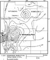
File:BasinCenteredGasFig14.jpg ...Sandstone in the Wattenburg field (modified from Higley et al., 1992). The field is nearly coincident with the 0.9% isoreflectance contour (Higley et al., 1(400 × 478 (53 KB)) - 16:30, 11 March 2015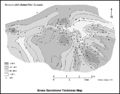
File:M91Ch11FG71.JPG ...al., 2002). From Shepherd, M., 2009, Lithofacies maps, in M. Shepherd, Oil field production geology: AAPG Memoir 91, p. 93-98.(800 × 629 (79 KB)) - 15:48, 27 April 2015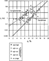
File:Core-log-transformations-and-porosity-permeability-relationships fig5.png ...permeability (run under stress) versus helium porosity from McArthur River Field, Alaska.(912 × 1,127 (19 KB)) - 18:06, 14 January 2014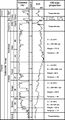
File:Mth14ch07f02.jpg ...ique Horizontal-well Designs Boost Primary and EOR Production, Prudhoe Bay Field, Alaska , by R. S. Tye, B. A. Watson, P. L. McGuire, and M. M. Maguire, Pag(500 × 923 (106 KB)) - 17:50, 7 December 2015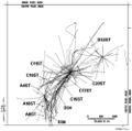
File:Mth14ch04f03.jpg ...nd Conclusions of a Horizontal-drilling Program at South Pass 62 Salt-dome Field, by E. P. Mason, M. J. Bastian, R. Detomo, M. N. Hashem, and A. J. Hildebra(500 × 495 (47 KB)) - 16:09, 7 December 2015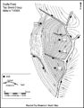
File:M91Ch13FG84.JPG .... From Shepherd, M., 2009, Structural geology: Faults, in M. Shepherd, Oil field production geology: AAPG Memoir 91, p. 107-122.(600 × 766 (134 KB)) - 21:34, 29 April 2015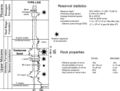
File:Mth14ch02f03.jpg ...Turbidite Reservoir--The ARCO-DOE 91X-3 Horizontal Well Project, Yowlumne Field, San Joaquin Basin, California in AAPG Methods in Exploration No. 14: Horiz(700 × 529 (75 KB)) - 15:26, 4 December 2015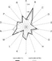
File:Mth14ch02f08.jpg ...Turbidite Reservoir--The ARCO-DOE 91X-3 Horizontal Well Project, Yowlumne Field, San Joaquin Basin, California in AAPG Methods in Exploration No. 14: Horiz(400 × 465 (28 KB)) - 20:19, 4 December 2015
File:Mth14ch04f06.jpg ...nd Conclusions of a Horizontal-drilling Program at South Pass 62 Salt-dome Field, by E. P. Mason, M. J. Bastian, R. Detomo, M. N. Hashem, and A. J. Hildebra(800 × 563 (141 KB)) - 16:55, 7 December 2015
File:Paleontology fig3.png Correlation of Rodessa Formation lithofacies at Running Duke Field, Houston County, Texas. Cores are indicated by solid vertical lines. (From(1,973 × 1,229 (190 KB)) - 17:38, 14 January 2014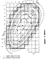
File:Conducting-a-reservoir-simulation-study-an-overview fig3.png Model grid overlain on Khursaniyah field, Saudi Arabia. (From Boberg, 1974; Copyright © 1974 Society of Petroleum E(926 × 1,188 (30 KB)) - 18:46, 14 January 2014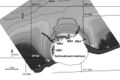
File:Mth14ch04f05.jpg ...nd Conclusions of a Horizontal-drilling Program at South Pass 62 Salt-dome Field, by E. P. Mason, M. J. Bastian, R. Detomo, M. N. Hashem, and A. J. Hildebra(700 × 469 (63 KB)) - 16:53, 7 December 2015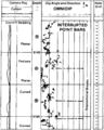
File:Dipmeters fig7.png Field example of a detailed dip computation through a sequence of interrupted mea(955 × 1,189 (73 KB)) - 01:19, 14 January 2014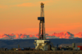
File:PinedaleFieldLandRig.png Drilling rig in Pinedale field with the Wind River Mountains, Wyoming, USA in the background. Photo by Dou(600 × 400 (426 KB)) - 21:00, 14 March 2014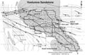
File:Mth14ch02f01.jpg ...Turbidite Reservoir--The ARCO-DOE 91X-3 Horizontal Well Project, Yowlumne Field, San Joaquin Basin, California in AAPG Methods in Exploration No. 14: Horiz(700 × 457 (103 KB)) - 23:18, 3 December 2015
File:Mth14ch04f01.jpg ...nd Conclusions of a Horizontal-drilling Program at South Pass 62 Salt-dome Field, by E. P. Mason, M. J. Bastian, R. Detomo, M. N. Hashem, and A. J. Hildebra(700 × 525 (111 KB)) - 16:00, 7 December 2015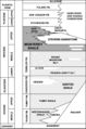
File:Mthch02f02.jpg ...Turbidite Reservoir--The ARCO-DOE 91X-3 Horizontal Well Project, Yowlumne Field, San Joaquin Basin, California in AAPG Methods in Exploration No. 14: Horiz(300 × 453 (36 KB)) - 15:19, 4 December 2015
File:Subsurface-maps fig4.png (a) Cross section and (b) net pay Isopach map of the Strachan gas field, western Canada. Contour Interval is 100 ft. (From Hriskevich et al., 1980.(890 × 1,386 (78 KB)) - 20:42, 14 January 2014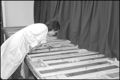
File:M91Ch6FG40.JPG ...on display. From Shepherd, M., 2009, Sources of data, in M. Shepherd, Oil field production geology: AAPG Memoir 91, p. 49-63.(600 × 402 (45 KB)) - 16:55, 3 June 2015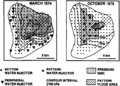
File:Subsurface-maps fig3.png Map of pressure response to pattern flood, Judy Creek field, western Canada, 1974 and 1975. Contour interval is 2750 kPa. (After Jardin(931 × 665 (79 KB)) - 20:42, 14 January 2014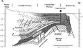
File:Mth14ch07f03.jpg ...ique Horizontal-well Designs Boost Primary and EOR Production, Prudhoe Bay Field, Alaska , by R. S. Tye, B. A. Watson, P. L. McGuire, and M. M. Maguire, Pag(700 × 409 (77 KB)) - 17:55, 7 December 2015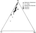
File:Oilfield-water-analysis fig1.png Triangular plot showing relative amounts of cations in typical oil field brines. Relative amount of sodium changes, but calcium is always about five(896 × 824 (10 KB)) - 17:24, 14 January 2014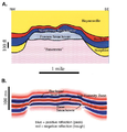
File:Reef1.png ...modeling of Figure 7 and (B) seismic section of the structure at Appleton field (modified from Balch and Hart, 2000).(471 × 491 (248 KB)) - 16:08, 20 November 2014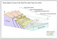
File:M115CH11FG03.jpg Summary of the “Brae Play” ([[Thelma field|Fraser et al., 2003]]). From AAPG Memoir 115—Rift-Related Coarse-Grained(1,283 × 870 (408 KB)) - 15:13, 22 January 2019
File:M91FG175.JPG ...rom Shepherd, M., 2009, Meandering fluvial reservoirs, in M. Shepherd, Oil field production geology: AAPG Memoir 91, p. 261-272.(800 × 520 (107 KB)) - 19:54, 3 August 2015
File:M91FG170.JPG ...ironments. From Shepherd, M., 2009, Eolian reservoirs, in M. Shepherd, Oil field production geology: AAPG Memoir 91, p. 255-259.(800 × 670 (90 KB)) - 17:03, 29 July 2015


