Search results
Jump to navigation
Jump to search
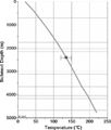
File:H4CH12FG5.JPG .... Shosa, M. J. Hardy, and M. B. Townsley, ''in'' Peters, Kenneth E., David J. Curry, and Marek Kacewicz, eds., Basin modeling: New horizons in research(600 × 707 (97 KB)) - 20:26, 9 July 2015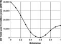
File:H4CH12FG10.JPG .... Shosa, M. J. Hardy, and M. B. Townsley, ''in'' Peters, Kenneth E., David J. Curry, and Marek Kacewicz, eds., Basin modeling: New horizons in research(600 × 439 (52 KB)) - 21:21, 13 July 2015
File:H4CH12FG3.JPG .... Shosa, M. J. Hardy, and M. B. Townsley, ''in'' Peters, Kenneth E., David J. Curry, and Marek Kacewicz, eds., Basin modeling: New horizons in research(600 × 252 (67 KB)) - 20:14, 9 July 2015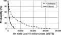
File:H4CH12FG12.JPG ...J. D. Shosa, M. J. Hardy, and M. B. Townsley, in Peters, Kenneth E., David J. Curry, and Marek Kacewicz, eds., Basin modeling: New horizons in research(600 × 346 (51 KB)) - 21:41, 13 July 2015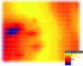
File:H4CH12FG13.JPG ...J. D. Shosa, M. J. Hardy, and M. B. Townsley, in Peters, Kenneth E., David J. Curry, and Marek Kacewicz, eds., Basin modeling: New horizons in research(600 × 480 (128 KB)) - 21:42, 13 July 2015
File:H4CH12FG11.JPG ...J. D. Shosa, M. J. Hardy, and M. B. Townsley, in Peters, Kenneth E., David J. Curry, and Marek Kacewicz, eds., Basin modeling: New horizons in research(600 × 322 (73 KB)) - 21:40, 13 July 2015
File:H4CH12FG4.JPG .... Shosa, M. J. Hardy, and M. B. Townsley, ''in'' Peters, Kenneth E., David J. Curry, and Marek Kacewicz, eds., Basin modeling: New horizons in research(600 × 369 (82 KB)) - 20:20, 9 July 2015
File:H4CH12FG2.JPG .... Shosa, M. J. Hardy, and M. B. Townsley, ''in'' Peters, Kenneth E., David J. Curry, and Marek Kacewicz, eds., Basin modeling: New horizons in research(800 × 581 (246 KB)) - 20:11, 9 July 2015
File:H4CH12FG8.JPG .... Shosa, M. J. Hardy, and M. B. Townsley, ''in'' Peters, Kenneth E., David J. Curry, and Marek Kacewicz, eds., Basin modeling: New horizons in research(600 × 372 (49 KB)) - 20:32, 13 July 2015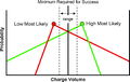
File:H4CH12FG1.JPG ...J. D. Shosa, M. J. Hardy, and M. B. Townsley, in Peters, Kenneth E., David J. Curry, and Marek Kacewicz, eds., Basin modeling: New horizons in research(600 × 378 (60 KB)) - 19:59, 9 July 2015
File:Sem-xrd-cl-and-xf-methods fig5.png {{copyright|W. J. Myers}} ...ght bands and higher Fe<sup>+2</sup> dolomite as dark bands. Copyright: W. J. Myers.(1,004 × 725 (583 KB)) - 22:29, 14 January 2014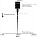
File:H4CH12FG7.JPG .... Shosa, M. J. Hardy, and M. B. Townsley, ''in'' Peters, Kenneth E., David J. Curry, and Marek Kacewicz, eds., Basin modeling: New horizons in research(600 × 599 (51 KB)) - 21:12, 9 July 2015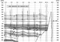
File:Mth14ch04f06.jpg ...dome Field, by E. P. Mason, M. J. Bastian, R. Detomo, M. N. Hashem, and A. J. Hildebrandt, Pages 49 - 65, in AAPG Methods in Exploration No. 14: Horizon(800 × 563 (141 KB)) - 16:55, 7 December 2015
File:H4CH12FG9.JPG .... Shosa, M. J. Hardy, and M. B. Townsley, ''in'' Peters, Kenneth E., David J. Curry, and Marek Kacewicz, eds., Basin modeling: New horizons in research(800 × 262 (80 KB)) - 20:34, 13 July 2015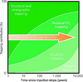
File:CO2TrappingMechanisms.JPG ...ut to selection and evaluation of CO2 geosequestration sites, in M. Grobe, J. C. Pashin, and R. L. Dodge, eds., Carbon dioxide sequestration in geologic(600 × 596 (131 KB)) - 18:25, 7 August 2014
File:H4CH12FG6.JPG .... Shosa, M. J. Hardy, and M. B. Townsley, ''in'' Peters, Kenneth E., David J. Curry, and Marek Kacewicz, eds., Basin modeling: New horizons in research(600 × 611 (85 KB)) - 21:07, 9 July 2015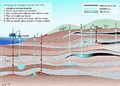
File:CO2StorageOptions.JPG ...ut to selection and evaluation of CO2 geosequestration sites, in M. Grobe, J. C. Pashin, and R. L. Dodge, eds., Carbon dioxide sequestration in geologic(800 × 570 (244 KB)) - 17:26, 7 August 2014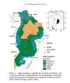
File:Parana 1.jpg Geological Map of the Paraná Basin. Milani E. J. 2004.(610 × 728 (86 KB)) - 17:38, 24 June 2015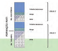
File:Sedimentary cycles of Irati Formation .png Sedimentary cycles of Irati Formation (Milani E. J., et al, 2007a)(689 × 609 (423 KB)) - 13:45, 24 June 2015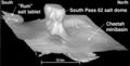
File:Mth14ch04f04.jpg ...dome Field, by E. P. Mason, M. J. Bastian, R. Detomo, M. N. Hashem, and A. J. Hildebrandt, Pages 49 - 65, in AAPG Methods in Exploration No. 14: Horizon(400 × 202 (17 KB)) - 16:51, 7 December 2015
File:Mth14ch04f03.jpg ...dome Field, by E. P. Mason, M. J. Bastian, R. Detomo, M. N. Hashem, and A. J. Hildebrandt, Pages 49 - 65, in AAPG Methods in Exploration No. 14: Horizon(500 × 495 (47 KB)) - 16:09, 7 December 2015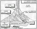
File:M31F1.jpg ...of a delta system. From Deltaic environments of deposition, 1981, Coleman, J. M., and D. B. Prior, in AAPG Memoir 31.(744 × 591 (256 KB)) - 18:15, 15 August 2014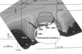
File:Mth14ch04f05.jpg ...dome Field, by E. P. Mason, M. J. Bastian, R. Detomo, M. N. Hashem, and A. J. Hildebrandt, Pages 49 - 65, in AAPG Methods in Exploration No. 14: Horizon(700 × 469 (63 KB)) - 16:53, 7 December 2015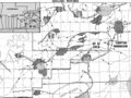
File:Mth14ch04f01.jpg ...dome Field, by E. P. Mason, M. J. Bastian, R. Detomo, M. N. Hashem, and A. J. Hildebrandt, Pages 49 - 65, ''in'' AAPG Methods in Exploration No. 14: Hor(700 × 525 (111 KB)) - 16:00, 7 December 2015
File:M31F4.jpg ...oint-bar deposits. From Deltaic environments of deposition, 1981, Coleman, J. M., and D. B. Prior, in AAPG Memoir 31.(1,464 × 916 (326 KB)) - 19:19, 15 August 2014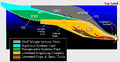
File:Systems Tracts.jpg .... From Seismic Stratigraphy-A Primer on Methodology by John W. Snedden and J. F. (Rick) Sarg, Search and Discovey Article #40270 (2008).(750 × 386 (174 KB)) - 20:29, 21 July 2014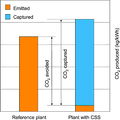
File:CO2EmissionsComparison.JPG ...ut to selection and evaluation of CO2 geosequestration sites, in M. Grobe, J. C. Pashin, and R. L. Dodge, eds., Carbon dioxide sequestration in geologic(600 × 600 (75 KB)) - 16:14, 7 August 2014
File:M31F6.jpg ...upper delta plain. From Deltaic environments of deposition, 1981, Coleman, J. M., and D. B. Prior, in AAPG Memoir 31.(1,467 × 1,013 (318 KB)) - 19:40, 15 August 2014
File:M31F3.jpg ...crop photographs). From Deltaic environments of deposition, 1981, Coleman, J. M., and D. B. Prior, in AAPG Memoir 31.(2,941 × 1,884 (830 KB)) - 19:02, 15 August 2014
File:Mth14ch04f02.jpg ...dome Field, by E. P. Mason, M. J. Bastian, R. Detomo, M. N. Hashem, and A. J. Hildebrandt, Pages 49 - 65, in AAPG Methods in Exploration No. 14: Horizon(500 × 718 (88 KB)) - 16:08, 7 December 2015
File:M31F16.jpg ...bifurcating distributary channel in the Mississippi River delta. Coleman, J. M., and D. B. Prior, 1981, Deltaic environments of deposition ''in'' P. A.(356 × 353 (54 KB)) - 18:14, 18 August 2014
File:M98Ch2Fig1.JPG ...earliest Ordovician (early Tremadocian): The Stonehenge transgression, in J. R. Derby, R. D. Fritz, S. A. Longacre, W. A. Morgan, and C. A. Sternbach,(800 × 915 (269 KB)) - 16:14, 19 August 2014
File:M106Ch07Fig02.jpg ...vents, and hydrocarbon occurrences. After NRA (2001). From Luning, S., and J. Kuss, 2014, Petroleum geology of Jordan, in L. Marlow, C. Kendall, and L.(700 × 566 (80 KB)) - 20:34, 18 April 2016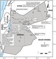
File:M106Ch07Fig07.jpg ...petroleum wells. After NRA (2001). 100 km (62.1 mi). From Luning, S., and J. Kuss, 2014, Petroleum geology of Jordan, in L. Marlow, C. Kendall, and L.(700 × 735 (86 KB)) - 21:41, 18 April 2016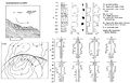
File:M31F26.jpg ...characteristics of slump deposits in the subaqueous delta plain. Coleman, J. M., and D. B. Prior, 1981, Deltaic environments of deposition ''in'' P. A.(1,499 × 968 (531 KB)) - 18:22, 18 August 2014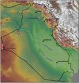
File:M106Ch12Fig01.jpg ...gas fields. Points of high elevation are indicated. From Grabowski Jr., G. J., 2014, Iraq, in L. Marlow, C. Kendall, and L. Yose, eds., Petroleum system(700 × 735 (96 KB)) - 20:15, 11 May 2016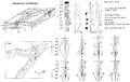
File:M31F13.jpg ...of the abandoned distributary deposits in the lower delta plain. Coleman, J. M., and D. B. Prior, 1981, Deltaic environments of deposition in P. A. Sch(1,508 × 950 (293 KB)) - 15:16, 18 August 2014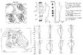
File:M31F9.jpg ...haracteristics of the bay-fill deposits in the lower delta plain. Coleman, J. M., and D. B. Prior, 1981, Deltaic environments of deposition in P. A. Sch(1,510 × 990 (305 KB)) - 15:13, 18 August 2014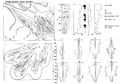
File:M31F22.jpg ...f river-mouth tidal ridge deposits in the subaqueous delta plain. Coleman, J. M., and D. B. Prior, 1981, Deltaic environments of deposition ''in'' P. A.(1,416 × 989 (554 KB)) - 18:20, 18 August 2014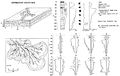
File:M31F17.jpg ...he distributary-mouth bar deposits in the subaqueous delta plain. Coleman, J. M., and D. B. Prior, 1981, Deltaic environments of deposition ''in'' P. A.(1,519 × 957 (150 KB)) - 18:17, 18 August 2014
File:M31F29.jpg ...on the continental shelf off the modern Mississippi River delta. Coleman, J. M., and D. B. Prior, 1981, Deltaic environments of deposition ''in'' P. A.(1,161 × 1,502 (970 KB)) - 18:25, 18 August 2014
File:M31F15.jpg ...Pass, Mississippi River delta. Diameter of cores is 8 cm (3 in.). Coleman, J. M., and D. B. Prior, 1981, Deltaic environments of deposition in P. A. Sch(1,194 × 1,001 (1.91 MB)) - 15:17, 18 August 2014
File:M31F23.jpg ...diapirs, and contemporary faults in the Mississippi River delta. Coleman, J. M., and D. B. Prior, 1981, Deltaic environments of deposition ''in'' P. A.(1,476 × 791 (905 KB)) - 18:20, 18 August 2014
File:M106Ch07Fig03.jpg ...ely older toward the west. From Lüning et al. (2006). From Luning, S., and J. Kuss, 2014, Petroleum geology of Jordan, in L. Marlow, C. Kendall, and L.(700 × 186 (24 KB)) - 20:47, 18 April 2016
File:M31F8.jpg ...ironment in the lower delta plain of the Mississippi River delta. Coleman, J. M., and D. B. Prior, 1981, Deltaic environments of deposition in P. A. Sch(744 × 752 (412 KB)) - 15:12, 18 August 2014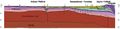
File:M106Ch12Fig05.jpg ...n northwestern Iraq, and ending in adjacent Turkey. From Grabowski Jr., G. J., 2014, Iraq, in L. Marlow, C. Kendall, and L. Yose, eds., Petroleum system(700 × 170 (23 KB)) - 13:57, 12 May 2016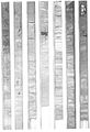
File:M31F11.jpg ...e distal end of the bay infill. Diameter of core is 8 cm (3 in.). Coleman, J. M., and D. B. Prior, 1981, Deltaic environments of deposition in P. A. Sch(951 × 1,393 (675 KB)) - 15:15, 18 August 2014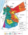
File:M106Ch07Fig1.jpg ...ydoun et al. (1994) and NRA (2001). 100 km (62.1 mi). From Luning, S., and J. Kuss, 2014, Petroleum geology of Jordan, in L. Marlow, C. Kendall, and L.(700 × 857 (97 KB)) - 20:28, 18 April 2016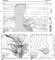
File:DiapirDiagram.JPG ...boundaries). Location given in (b). (b) Structure contour map drawn on the J horizon. (c) Structure contour map drawn on the B horizon. From AAPG Bullet(800 × 870 (270 KB)) - 17:59, 2 January 2015
File:M106Ch12Fig06.jpg ...e Zagros foldbelt in eastern Iraq. 50 km (31.1 mi). From Grabowski Jr., G. J., 2014, Iraq, in L. Marlow, C. Kendall, and L. Yose, eds., Petroleum system(690 × 337 (55 KB)) - 13:59, 12 May 2016


