Search results
Jump to navigation
Jump to search
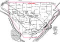
File:BlackWarriorBasinFG1.JPG Black Warrior Basin. 20 mi (32 km). From Fritz et al., 2012, Great American Carbonate Bank: Knox Group in the(800 × 563 (178 KB)) - 15:47, 5 January 2015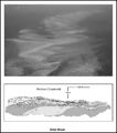
File:M91FG196.JPG Ooid shoal, Bahamas; the bottom edge of the photograph represents a 4.5-km (2.7 mi)-wide transect. The lower inset is an illustration of a cliff expos(800 × 909 (88 KB)) - 13:08, 20 August 2015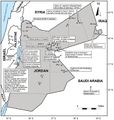
File:M106Ch07Fig07.jpg ...w of hydrocarbon shows in Jordanian petroleum wells. After NRA (2001). 100 km (62.1 mi). From Luning, S., and J. Kuss, 2014, Petroleum geology of Jordan,(700 × 735 (86 KB)) - 21:41, 18 April 2016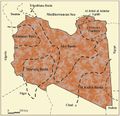
File:M106Ch04Fig03.jpg Sedimentary basins of Libya (productive basins, future prospective) 200 km (124.3 mi). From Hassan, H. S., and C. C. G. Kendall, 2014, Hydrocarbon pro(700 × 676 (77 KB)) - 20:13, 28 March 2016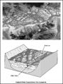
File:M91FG181.JPG ...llite photo of a braided river in Tibet. The braided river belt is about 7 km (4 mi) wide. Courtesy of the NASA Web site (www.earthobservatory.nasa.gov).(600 × 805 (104 KB)) - 21:18, 10 August 2015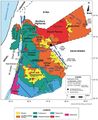
File:M106Ch07Fig1.jpg ...fields in Jordan. Modified after Beydoun et al. (1994) and NRA (2001). 100 km (62.1 mi). From Luning, S., and J. Kuss, 2014, Petroleum geology of Jordan,(700 × 857 (97 KB)) - 20:28, 18 April 2016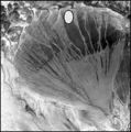
File:M91Ch11FG69.JPG ...ial fan in China's Xinjuang Province. The diameter of the fan is about 170 km (106 mi). Courtesy of the NASA Web site: www.earthasart.gsfc.nasa.gov. Show(600 × 606 (106 KB)) - 15:42, 27 April 2015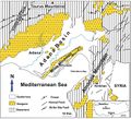
File:M106Ch13Fig11.jpg ...Adana and İskenderun subbasins (redrawn from Derman and Gürbüz, 2007). 10 km (6.2 mi). From Derman, Ahmet Sami, 2014, Petroleum systems of Turkish Basin(700 × 637 (109 KB)) - 20:03, 5 July 2016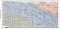
File:M106Ch12Fig06.jpg ...cross the Mesopotamian Foredeep to the Zagros foldbelt in eastern Iraq. 50 km (31.1 mi). From Grabowski Jr., G. J., 2014, Iraq, in L. Marlow, C. Kendall,(690 × 337 (55 KB)) - 13:59, 12 May 2016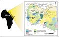
File:M106h04Fig01.jpg ...ajor tectonic elements (modified after Rusk, 2001; Ramos et al., 2006) 500 km (310.7 mi). From Hassan, Hassan S. and Christopher C. G. Kendall, Hydrocarb(700 × 439 (50 KB)) - 19:01, 28 March 2016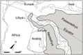
File:M106Ch07Fig05.jpg ...orthern Arabia and Northeast Africa. After Stampfli and Borel (2002). 1500 km (932 mi). From Lüning et al. (2006). From Luning, S., and J. Kuss, 2014, P(700 × 468 (49 KB)) - 21:06, 18 April 2016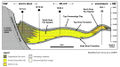
File:M115CH10FG03.jpg ...gh the Miller field area to the distal margin near the Kingfisher field 15 km (9 mi) to the northeast. Modified after [[Kingfisher field|Turner et al. (1(1,076 × 597 (435 KB)) - 18:42, 17 January 2019
File:M91FG186.JPG ...asart.gsfc.nasa.gov). The inset box on the photograph measures 34 times 42 km (21 times 26 mi). The lower diagram is a box diagram showing the sedimentol(800 × 1,137 (157 KB)) - 19:22, 13 August 2015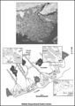
File:M91FG184.JPG ...f the NASA Web site (www.earthasart.gsfc.nasa.gov). The delta is about 200 km (124 mi) across in this view. The photograph has been rotated such that nor(800 × 1,134 (191 KB)) - 20:10, 12 August 2015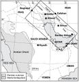
File:M106Ch14Fig01.jpg ...gure 2. Permian outcrops surrounding the Arabian shield are indicated. 200 km (124.3 mi). From M. L. Bordenave, 2014, Petroleum Systems and Distribution(641 × 662 (94 KB)) - 18:05, 12 July 2016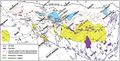
File:M106Ch14Fig12.jpg ...ndicating the regional highs as they appear before the Zagros folding. 100 km (62.1 mi). From M. L. Bordenave, 2014, Petroleum Systems and Distribution o(700 × 356 (74 KB)) - 19:40, 12 July 2016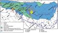
File:M106Ch14Fig14.jpg ...al highs close to the Mesopotamian depression area are also indicated. 100 km (62.1 mi). From M. L. Bordenave, 2014, Petroleum Systems and Distribution o(700 × 402 (73 KB)) - 19:35, 12 July 2016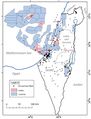
File:M106Ch06Fig03.jpg ...ormation in the Israel Ministry of Energy and Water Resources website). 50 km (31.1 mi). From Gardosh, Michael A., and Eli Tannenbaum, 2014, The petroleu(700 × 917 (76 KB)) - 15:29, 23 February 2016
File:M31F24.jpg ...ide gullies in the Mississippi River delta. The width of the mosaic is 1.5 km, and the superimposed grid is a 25-m square. The slope is from top (approxi(758 × 947 (524 KB)) - 18:21, 18 August 2014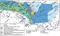
File:M106Ch14Fig11.jpg ...al highs close to the Mesopotamian depression area are also indicated. 100 km (62.1 mi). From M. L. Bordenave, 2014, Petroleum Systems and Distribution o(700 × 422 (79 KB)) - 18:36, 12 July 2016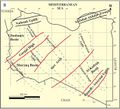
File:M106Ch04Fig2B.jpg ...s: Klitzsch (1971), Zegaar (1986), Anketell (1996), and Hallett (2002) 500 km (310.7 mi). From Hassan, H. S., and C. C. G. Kendall, 2014, Hydrocarbon pro(700 × 635 (73 KB)) - 19:43, 28 March 2016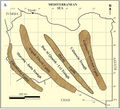
File:M106Ch04Fig2A.jpg ...s: Klitzsch (1971), Zegaar (1986), Anketell (1996), and Hallett (2002) 500 km (310.7 mi). From Hassan, H. S., and C. C. G. Kendall, 2014, Hydrocarbon pro(700 × 633 (66 KB)) - 19:44, 28 March 2016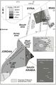
File:M106Ch07Fig04.jpg ...adjusted according to offset shale baseline. From Lüning et al. (2006). 5 km (3.1 mi). From Lüning et al. (2006). From Luning, S., and J. Kuss, 2014, P(564 × 855 (75 KB)) - 20:49, 18 April 2016
File:M106Ch12Fig02.jpg ...to be caused by the structural grain of Precambrian accreted terrains. 200 km (124.3 mi). From Grabowski Jr., G. J., 2014, Iraq, in L. Marlow, C. Kendall(700 × 373 (52 KB)) - 20:26, 11 May 2016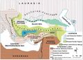
File:M106Ch13Fig01.jpg ...y an ophiolitic suite of rocks (redrawn from Şengör and Yilmaz, 1981). 300 km (186.4 mi). From Derman, Ahmet Sami, 2014, Petroleum systems of Turkish Bas(700 × 513 (90 KB)) - 19:29, 5 July 2016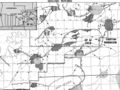
File:Mth14ch04f01.jpg South Pass 62 field is located 50 km southeast of the mouth of the Mississippi River in 100 m of water. Dark gra(700 × 525 (111 KB)) - 16:00, 7 December 2015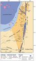
File:M106Ch06Fig02.jpg ...Numbers refer to oil fields and hydrocarbon shows detailed in Table 1. 50 km (31.1 mi). From Gardosh, Michael A., and Eli Tannenbaum, 2014, The petroleu(489 × 824 (63 KB)) - 15:25, 23 February 2016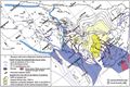
File:M106Ch14Fig13.jpg ...abia), and migration paths from the kitchens toward the Gavbendi High. 100 km (62.1 mi). From M. L. Bordenave, 2014, Petroleum Systems and Distribution o(700 × 464 (101 KB)) - 18:44, 12 July 2016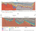
File:M114CH03FG03.jpg ...n the southern part of the basin are at burial depths present day of ca. 3 km and have not been significantly inverted. The large, deep fault northwest o(700 × 600 (112 KB)) - 17:49, 4 January 2019


