Search results
Jump to navigation
Jump to search
- ...cally occurs approximately 35 km (~19 mi) below the continents and 5 to 10 km (3-5 mi) below the floor of the ocean.<ref name=Petersetal_2012>Peters, Ken729 bytes (103 words) - 15:49, 4 December 2015
- ...onian sediments in the Ainsa Basin<ref>Dreyer et al</ref>. It contains 5.5 km of continuous outcrop exposure from the shelf-edge delta to the distal slop ...he south of the town of Ainsa, Huesca, Spain. It is about 25 km wide by 75 km long, and is bound on the east by the Rio Cinca, and the west by the Colina1 KB (163 words) - 00:12, 30 June 2014
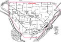
File:BlackWarriorBasinFG1.JPG Black Warrior Basin. 20 mi (32 km). From Fritz et al., 2012, Great American Carbonate Bank: Knox Group in the(800 × 563 (178 KB)) - 15:47, 5 January 2015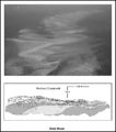
File:M91FG196.JPG Ooid shoal, Bahamas; the bottom edge of the photograph represents a 4.5-km (2.7 mi)-wide transect. The lower inset is an illustration of a cliff expos(800 × 909 (88 KB)) - 13:08, 20 August 2015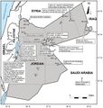
File:M106Ch07Fig07.jpg ...w of hydrocarbon shows in Jordanian petroleum wells. After NRA (2001). 100 km (62.1 mi). From Luning, S., and J. Kuss, 2014, Petroleum geology of Jordan,(700 × 735 (86 KB)) - 21:41, 18 April 2016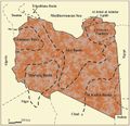
File:M106Ch04Fig03.jpg Sedimentary basins of Libya (productive basins, future prospective) 200 km (124.3 mi). From Hassan, H. S., and C. C. G. Kendall, 2014, Hydrocarbon pro(700 × 676 (77 KB)) - 20:13, 28 March 2016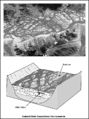
File:M91FG181.JPG ...llite photo of a braided river in Tibet. The braided river belt is about 7 km (4 mi) wide. Courtesy of the NASA Web site (www.earthobservatory.nasa.gov).(600 × 805 (104 KB)) - 21:18, 10 August 2015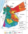
File:M106Ch07Fig1.jpg ...fields in Jordan. Modified after Beydoun et al. (1994) and NRA (2001). 100 km (62.1 mi). From Luning, S., and J. Kuss, 2014, Petroleum geology of Jordan,(700 × 857 (97 KB)) - 20:28, 18 April 2016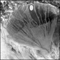
File:M91Ch11FG69.JPG ...ial fan in China's Xinjuang Province. The diameter of the fan is about 170 km (106 mi). Courtesy of the NASA Web site: www.earthasart.gsfc.nasa.gov. Show(600 × 606 (106 KB)) - 15:42, 27 April 2015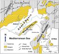
File:M106Ch13Fig11.jpg ...Adana and İskenderun subbasins (redrawn from Derman and Gürbüz, 2007). 10 km (6.2 mi). From Derman, Ahmet Sami, 2014, Petroleum systems of Turkish Basin(700 × 637 (109 KB)) - 20:03, 5 July 2016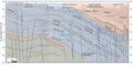
File:M106Ch12Fig06.jpg ...cross the Mesopotamian Foredeep to the Zagros foldbelt in eastern Iraq. 50 km (31.1 mi). From Grabowski Jr., G. J., 2014, Iraq, in L. Marlow, C. Kendall,(690 × 337 (55 KB)) - 13:59, 12 May 2016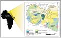
File:M106h04Fig01.jpg ...ajor tectonic elements (modified after Rusk, 2001; Ramos et al., 2006) 500 km (310.7 mi). From Hassan, Hassan S. and Christopher C. G. Kendall, Hydrocarb(700 × 439 (50 KB)) - 19:01, 28 March 2016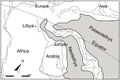
File:M106Ch07Fig05.jpg ...orthern Arabia and Northeast Africa. After Stampfli and Borel (2002). 1500 km (932 mi). From Lüning et al. (2006). From Luning, S., and J. Kuss, 2014, P(700 × 468 (49 KB)) - 21:06, 18 April 2016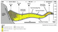
File:M115CH10FG03.jpg ...gh the Miller field area to the distal margin near the Kingfisher field 15 km (9 mi) to the northeast. Modified after [[Kingfisher field|Turner et al. (1(1,076 × 597 (435 KB)) - 18:42, 17 January 2019
File:M91FG186.JPG ...asart.gsfc.nasa.gov). The inset box on the photograph measures 34 times 42 km (21 times 26 mi). The lower diagram is a box diagram showing the sedimentol(800 × 1,137 (157 KB)) - 19:22, 13 August 2015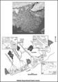
File:M91FG184.JPG ...f the NASA Web site (www.earthasart.gsfc.nasa.gov). The delta is about 200 km (124 mi) across in this view. The photograph has been rotated such that nor(800 × 1,134 (191 KB)) - 20:10, 12 August 2015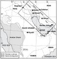
File:M106Ch14Fig01.jpg ...gure 2. Permian outcrops surrounding the Arabian shield are indicated. 200 km (124.3 mi). From M. L. Bordenave, 2014, Petroleum Systems and Distribution(641 × 662 (94 KB)) - 18:05, 12 July 2016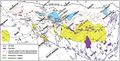
File:M106Ch14Fig12.jpg ...ndicating the regional highs as they appear before the Zagros folding. 100 km (62.1 mi). From M. L. Bordenave, 2014, Petroleum Systems and Distribution o(700 × 356 (74 KB)) - 19:40, 12 July 2016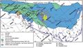
File:M106Ch14Fig14.jpg ...al highs close to the Mesopotamian depression area are also indicated. 100 km (62.1 mi). From M. L. Bordenave, 2014, Petroleum Systems and Distribution o(700 × 402 (73 KB)) - 19:35, 12 July 2016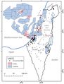
File:M106Ch06Fig03.jpg ...ormation in the Israel Ministry of Energy and Water Resources website). 50 km (31.1 mi). From Gardosh, Michael A., and Eli Tannenbaum, 2014, The petroleu(700 × 917 (76 KB)) - 15:29, 23 February 2016


