Search results
Jump to navigation
Jump to search
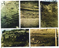
File:M31F5.jpg .... E. Soil zones alternating with ripple laminations in upper part of point-bar deposits. From Deltaic environments of deposition, 1981, Coleman, J. M., an(1,152 × 941 (941 KB)) - 19:33, 15 August 2014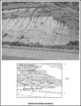
File:M91FG178.JPG ...n the upper section of a point bar sandstone, Ebro basin, Spain. The point bar grew by accretion from left to right. From Shepherd, M., 2009, Meandering f(800 × 1,042 (186 KB)) - 21:26, 3 August 2015
File:M31F18.jpg ...layers common to the small overbank splays that cap the distributary-mouth bar deposits. Coleman, J. M., and D. B. Prior, 1981, Deltaic environments of de(1,349 × 994 (1.86 MB)) - 18:16, 18 August 2014
File:M31F19.jpg ...y-mouth bar sequence. This section represents the lower part of the distal bar deposit. Diameter of cores is 8 cm (3 in.). Coleman, J. M., and D. B. Prior(1,343 × 1,017 (615 KB)) - 18:17, 18 August 2014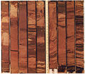
File:M31F20.jpg ...sequence. This section represents the lower part of the distributary-mouth bar deposit. Diameter of cores is 8 cm (3 in.). Coleman, J. M., and D. B. Prior(1,158 × 1,014 (1.94 MB)) - 18:18, 18 August 2014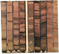
File:M31F21.jpg ...sequence. This section represents the upper part of the distributary-mouth bar deposits. Diameter of cores is 8 cm (3 in.). Coleman, J. M., and D. B. Prio(1,120 × 1,026 (1.69 MB)) - 18:19, 18 August 2014
File:M91FG179.JPG ...the Sweetwater field, which produces from a depositionally isolated point bar in the same meander belt system (from Werren et al., 1990). Reprinted with(800 × 984 (103 KB)) - 21:50, 3 August 2015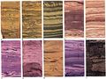
File:M31F10v2.jpg ...-sorted cross-stratified sands of the upper part of the distributary-mouth bar (bay fill sequence). I. Alternating silts and silty clays of the overbank s(1,334 × 1,000 (178 KB)) - 15:14, 18 August 2014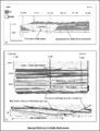
File:M91FG190.JPG ...ar in the Ivishak Formation, Prudhoe Bay field. Bay shales above the mouth bar act to prevent gas ingress from a gas cap immediately above (from Tye et al(800 × 1,047 (162 KB)) - 18:05, 20 August 2015
File:M31F4.jpg Summary diagram illustrating the major characteristics of meandering point-bar deposits. From Deltaic environments of deposition, 1981, Coleman, J. M., an(1,464 × 916 (326 KB)) - 19:19, 15 August 2014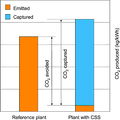
File:CO2EmissionsComparison.JPG ...ction (CO2 avoided) of 80-90% compared to the reference power plant (upper bar) without capture. CCS = carbon capture and storage. From Kaldi, J. G., C. M(600 × 600 (75 KB)) - 16:14, 7 August 2014
File:M91FG108.JPG The barrier bar-shoreface interval of the Brent Group reservoir in the Thistle field, UK No(800 × 1,069 (99 KB)) - 21:26, 12 August 2015
File:M91Ch11FG70.JPG A point bar cut into the underlying Ivan limestone as picked out by varying seismic amp(600 × 353 (134 KB)) - 15:46, 27 April 2015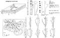
File:M31F17.jpg ...y diagram illustrating the major characteristics of the distributary-mouth bar deposits in the subaqueous delta plain. Coleman, J. M., and D. B. Prior, 19(1,519 × 957 (150 KB)) - 18:17, 18 August 2014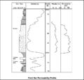
File:M91FG177.JPG Upward-decreasing permeability profile in a point bar sandstone in the Peoria field, Colorado (from Chapin and Mayer, 1991). Repr(800 × 765 (56 KB)) - 21:21, 3 August 2015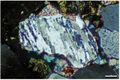
File:M109CH01Polychristalline.jpg ...s. In addition, crystal boundaries are diffuse. XPL, AFeS, KFS, BDI, Scale bar = 0.07 mm. From From AAPG Memoir 109—A Color Guide to the Petrography of(655 × 438 (71 KB)) - 20:07, 23 January 2019
File:M109CH01Monocrystalline.jpg ...t) around the upper part of the grain has far fewer inclusions. XPL, Scale bar = 0.26 mm. From From AAPG Memoir 109—A Color Guide to the Petrography of(656 × 439 (87 KB)) - 20:20, 23 January 2019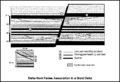
File:M91FG189.JPG ...tiary of the Apsheron Peninsula, Azerbaijan. A stacked succession of mouth-bar and channel sandstones is vertically sealed by delta-front siltstones. Inte(800 × 544 (102 KB)) - 16:57, 20 August 2015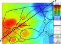
File:H4CH12FG2.JPG ...es are outlined in red, and the escape paths are shown in green. The scale bar in the legend represents 12,500 m (41,010 ft). From Identifying and quantif(800 × 581 (246 KB)) - 20:11, 9 July 2015


