Search results
Jump to navigation
Jump to search
File:H4CH12FG9.JPG ...starts generating during the last 2 m.y. In the large extension case, the Cretaceous and Jurassic source rocks are depleted, and the Miocene source rock is gene(800 × 262 (80 KB)) - 20:34, 13 July 2015
File:2.png Figure 2. Jurassic and Lower Cretaceous lithostratigraphy of the Neuquén Basin. Based on Spalletti & Veiga (2007).(376 × 491 (118 KB)) - 16:48, 26 June 2015
File:Borehole-imaging-devices fig8.png ...ion MicroScanner images showing dipping unconformity at contact (arrow) of Cretaceous clastic rocks with Mississippian carbonates.(1,013 × 930 (416 KB)) - 18:53, 13 January 2014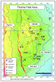
File:M115CH11FG02.jpg Thelma area: Base Cretaceous depth structure map. From AAPG Memoir 115—Rift-Related Coarse-Grained Sub(743 × 1,094 (881 KB)) - 15:12, 22 January 2019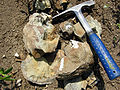
File:BrokenConcretion22.jpg A broken concretion with fossils inside; Upper Cretaceous Pierre shale, near Ekalaka, Montana. Photograph taken by Mark A. Wilson (De(1,200 × 900 (698 KB)) - 16:20, 10 September 2014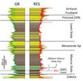
File:Figure1MancosCommRept.jpg Type logs through the Cretaceous section of the San Juan Basin, showing the principle stratigraphic units. N(887 × 865 (285 KB)) - 20:49, 14 April 2021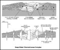
File:M91FG195.JPG ...annel-levee complex based on outcrops from the Cerro Toro Formation, Upper Cretaceous, southern Chile (from Beaubouef, 2004). The lower section shows a series of(800 × 669 (93 KB)) - 15:36, 17 August 2015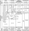
File:BasinCenteredGasFig5.jpg Generalized stratigraphic correlation chart of Cretaceous and lower Tertiary rocks in the Greater Green River basin, Wyoming and Colo(700 × 753 (121 KB)) - 17:54, 14 January 2015
File:M91FG196.JPG ...a cliff exposure of laterally accreting (shingled) oolites from the Lower Cretaceous of Northern Mexico (from Osleger, 2004). Reprinted with permission from the(800 × 909 (88 KB)) - 13:08, 20 August 2015
File:Figure1AustinChalk2019-20CommRept.jpg Stratigraphic columns for Upper Cretaceous rocks from South Texas to Mississippi (Pearson, 2012). Shows reservoir rock(579 × 499 (288 KB)) - 20:54, 5 April 2021
File:M106Ch01Fig10.jpg ...l settings in the southern margin of the Tethys (below) at the time of the Cretaceous-Paleocene boundary (about 65.5 Ma). From F. Berra and L. Angiolini, 2014, T(700 × 1,144 (154 KB)) - 20:35, 18 February 2016
File:M109CH01Monocrystalline.jpg Lower Cretaceous Travis Peak Formation, Eastland County, Texas, Monocrystalline quartz grain(656 × 439 (87 KB)) - 20:20, 23 January 2019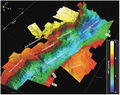
File:M115CH02FG02.jpg ...South Viking Graben and southern part of the Central Viking Graben at Base Cretaceous level, viewed from the southeast. Location of image shown in [[South Viking(700 × 552 (112 KB)) - 20:30, 10 January 2019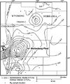
File:BasinCenteredGasFig14.jpg ...Denver basin, Colorado, showing the large thermal maturity anomaly in the Cretaceous Muddy ("J") Sandstone in the Wattenburg field (modified from Higley et al.,(400 × 478 (53 KB)) - 16:30, 11 March 2015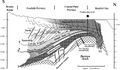
File:Mth14ch07f03.jpg ...e Ivishak Formation is draped over the Barrow Arch, truncated by the Lower Cretaceous unconformity, and overlain by marine shales. Location is shown in Figure 1(700 × 409 (77 KB)) - 17:55, 7 December 2015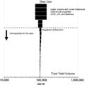
File:H4CH12FG7.JPG ...s example, uncertainties in the properties of the Upper Jurassic and Lower Cretaceous source rocks have the most effect on the total oil yield. oTOC and oHI are(600 × 599 (51 KB)) - 21:12, 9 July 2015
File:M115CH02FG03.jpg ...und Spur and Utsira High have pre-Upper Jurassic rocks beneath Cenozoic or Cretaceous strata (with very thin, <approximately 2 m [6.6 ft], KCF-Draupne Formation(700 × 767 (157 KB)) - 21:29, 10 January 2019


