Search results
Jump to navigation
Jump to search
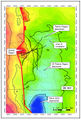
File:M115CH11FG07.jpg ...ssic isochron map of the Thelma area illustrating the presence of a Middle Jurassic structural high under the Central region. From AAPG Memoir 115—Rift-Relat(791 × 1,176 (1.05 MB)) - 15:26, 22 January 2019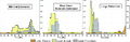
File:H4CH12FG9.JPG ...ing during the last 2 m.y. In the large extension case, the Cretaceous and Jurassic source rocks are depleted, and the Miocene source rock is generating oil. F(800 × 262 (80 KB)) - 20:34, 13 July 2015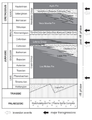
File:2.png Figure 2. Jurassic and Lower Cretaceous lithostratigraphy of the Neuquén Basin. Based on Spal(376 × 491 (118 KB)) - 16:48, 26 June 2015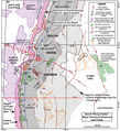
File:M115CH02FG03.jpg ...servoirs are shown with black outlines; fields and discoveries with Middle Jurassic and older reservoirs are shown with orange outlines. Most faults shown are(700 × 767 (157 KB)) - 21:29, 10 January 2019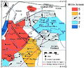
File:FG11.JPG ...er). In AAPG Bulletin, v 96, no. 11, Tectonostratigraphic evolution of the Jurassic extensional basins of the eastern southern Alps and Adriatic foreland based(800 × 648 (291 KB)) - 15:04, 5 August 2014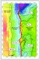
File:M115CH11FG06.jpg T-Block Upper Jurassic isochron map illustrating graben complexity and distribution of depocenters(785 × 1,160 (1.14 MB)) - 15:25, 22 January 2019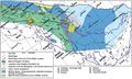
File:M106Ch14Fig11.jpg Paleogeography reconstruction during the Middle Jurassic and distribution of the Sargelu source rocks in the Mesopotamian depression(700 × 422 (79 KB)) - 18:36, 12 July 2016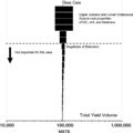
File:H4CH12FG7.JPG ...els [MSTB]). In this example, uncertainties in the properties of the Upper Jurassic and Lower Cretaceous source rocks have the most effect on the total oil yie(600 × 599 (51 KB)) - 21:12, 9 July 2015


