Search results
Jump to navigation
Jump to search
File:Figure1EagleFord2019-20CommRept.jpg ...Texas Natural Resources Information, U.S. Geological Survey, University of Texas Bureau of Economic Geology (from U.S. EIA, January 21, 2015).(432 × 296 (123 KB)) - 21:52, 6 April 2021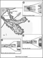
File:M91FG193.JPG ...l for channelized turbidites and a basin-floor fan complex, Brushy Canyon, Texas. From Beaubouef (1999). Reprinted with permission from the AAPG.(800 × 1,075 (131 KB)) - 16:25, 14 August 2015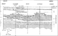
File:Paleontology fig3.png ...on of Rodessa Formation lithofacies at Running Duke Field, Houston County, Texas. Cores are indicated by solid vertical lines. (From Scott, 1990.)(1,973 × 1,229 (190 KB)) - 17:38, 14 January 2014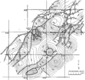
File:Subsurface-maps fig1.png Structure map of the top of the T5 marker, Frlo Formation, Brazoria County, Texas. (After Bebout et al., 1978.)(1,865 × 1,746 (308 KB)) - 20:42, 14 January 2014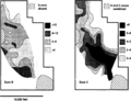
File:Subsurface-maps fig6.png ...he San Andres Formation reservoir, Jordan field, Ector and Crane Counties, Texas. Contours in PV fraction-feet. (After Major and Holtz, 1989.)(1,944 × 1,484 (237 KB)) - 20:42, 14 January 2014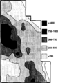
File:Subsurface-maps fig7.png ...he San Andres Formation reservoir, Jordan field, Ector and Crane counties, Texas. Contours in MSTB/year/acre. (After Major and Holtz, 1989.)(944 × 1,353 (62 KB)) - 20:42, 14 January 2014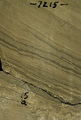
File:FG18CoreSt63Appendix3.JPG ...nate reservoir: Fullerton Clear Fork (Lower Permian) field, Permian Basin, Texas: AAPG Studies in Geology 63.(600 × 890 (315 KB)) - 16:10, 29 June 2015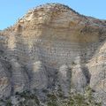
File:Eagle-ford-gets-spotlight04.jpg West Texas' Lozier Canyon offers an opportunity to examine Eagle Ford Shale outcrops a(400 × 400 (80 KB)) - 16:20, 18 June 2014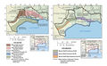
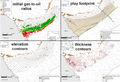
File:Figure3AustinChalk2019-20CommRept.jpg ...recoverable oil and gas resources in the Austin Chalk and related units in Texas and Louisiana. (Pitman et al., 2020).(1,789 × 1,110 (895 KB)) - 21:21, 5 April 2021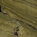
File:MainPageFG18CoreSt63Appendix3.jpg ...nate reservoir: Fullerton Clear Fork (Lower Permian) field, Permian Basin, Texas: AAPG Studies in Geology 63. Used on Core description article.(400 × 400 (104 KB)) - 16:14, 29 June 2015
File:M91Ch11FG70.JPG ...on a horizon display, late Pennsylvanian to Early Permian, Baylor County, Texas (from Burnett, 1996). From Shepherd, M., 2009, Lithofacies maps, in M. Shep(600 × 353 (134 KB)) - 15:46, 27 April 2015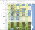
File:Figure1AustinChalk2019-20CommRept.jpg Stratigraphic columns for Upper Cretaceous rocks from South Texas to Mississippi (Pearson, 2012). Shows reservoir rocks (Austin Chalk, Tokio(579 × 499 (288 KB)) - 20:54, 5 April 2021
File:M91FG117.JPG ...aps from the West Cornelius reservoir, North Markham-North Bay City field, Texas. In this strand-plain reservoir, east-northeastndashwest-southwest-oriented(800 × 689 (66 KB)) - 21:32, 12 August 2015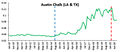
File:Figure2AustinChalk2019-20CommRept.jpg Austin Chalk production (combining Texas and Louisiana) from January 2010 through September 2020 in millions of barr(468 × 202 (56 KB)) - 21:13, 5 April 2021
File:M109CH01Monocrystalline.jpg Lower Cretaceous Travis Peak Formation, Eastland County, Texas, Monocrystalline quartz grain with exceptionally abundant vacuoles (probabl(656 × 439 (87 KB)) - 20:20, 23 January 2019
File:M91FG199.JPG ...rmian San Andres dolomite of the northern Delaware basin in New Mexico and Texas (after Shinn, 1983). Repeated transgression and regression create cycles of(800 × 1,089 (126 KB)) - 13:11, 20 August 2015


