Search results
Jump to navigation
Jump to search
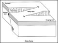
File:M91Ch13FG86.JPG ...ng faults. They potentially provide pathways for fluid flow across a fault zone (from Peacock and Sanderson, 1994). From Shepherd, M., 2009, Structural geo(600 × 444 (30 KB)) - 21:35, 29 April 2015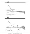
File:M91Figure163.JPG ...ing the bed dip. If the assumed dip is wrong, the well may exit the target zone. Problems also occur if the well crosses an unexpected fault. From Chapter(600 × 693 (39 KB)) - 19:49, 30 July 2014
File:Full-waveform-acoustic-logging fig2.png FWAL microseismograms across a fracture zone.(948 × 598 (66 KB)) - 17:49, 13 January 2014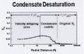
File:AlAhmadiTawfiqFigure5.jpg ...e Saturation versus Radial Distance from wellbore, with velocity stripping zone (Daungkaew & Gringarten, 2004).(538 × 350 (44 KB)) - 23:03, 9 November 2021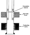
File:Well-completions fig6.png Wellbore diagram of a single completion with an alternative zone.(922 × 1,066 (45 KB)) - 21:20, 14 January 2014
File:AlsaudKatterbauerFigure2.jpg Cross-well EM current direction between the wells and to the targeted zone.(255 × 181 (16 KB)) - 22:12, 3 February 2022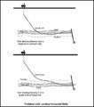
File:M91Figure162.JPG Problems can be encountered with landing a horizontal well if the target zone is too high or too low compared to what is predicted. From Chapter 28, AAPG(600 × 682 (38 KB)) - 19:32, 30 July 2014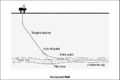
File:M91Figure161.JPG ...nt of keeping the well within a specific reservoir interval or hydrocarbon zone. From Chapter 28, AAPG Memoir 91, by Mike Shepherd(800 × 534 (36 KB)) - 19:25, 30 July 2014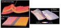
File:AlHawajAlQahtaniFigure1.jpg 3D restoration conducted on a faulted and folded layer (Sub-Andean Zone, Bolivia), showing a) the deformed state and b) the restored state. c) Dist(979 × 447 (95 KB)) - 20:44, 8 November 2021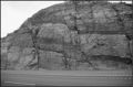
File:M91Ch13FG87.JPG Fault damage zone from Moab, Utah. The outcrop is about 15 m (49 ft) high (photo courtesy of(600 × 396 (78 KB)) - 21:36, 29 April 2015
File:Seismic-inversion fig6.png Time slice displays through the 3-D survey of the river channel zone. The lightly shaded areas show low velocity material in which reservoir san(2,045 × 1,222 (1.56 MB)) - 19:34, 14 January 2014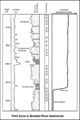
File:M91FG183.JPG A high-permeability conglomeratic thief zone from the braided river reservoir of the Prudhoe Bay field, Alaska (from Atk(800 × 1,199 (103 KB)) - 19:00, 12 August 2015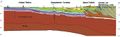
File:M106Ch12Fig04.jpg ...dbelt in eastern Iraq and adjacent Iran, and ending at the Sirjan-Sanandaj zone in Iran. From Grabowski Jr., G. J., 2014, Iraq, in L. Marlow, C. Kendall, a(700 × 215 (27 KB)) - 13:55, 12 May 2016
File:Wireline-formation-testers fig7.png Pressure contour map in zone of water injection. Copyright: Western Atlas International, 1987</xref>; co(1,947 × 1,503 (110 KB)) - 21:44, 14 January 2014
File:M31F2.jpg ...B. Trough-shaped cross-bedding in lenticular sets that form the overlying zone in a fining-upward cycle of a braided channel. C. Ripple drift bedding sepa(365 × 772 (175 KB)) - 18:56, 15 August 2014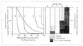
File:Charles-l-vavra-john-g-kaldi-robert-m-sneider capillary-pressure 5.jpg ...ighly irregular vertical saturation profile. Note also the wide transition zone in rock type B caused by poor sorting of the pore throats.(1,200 × 670 (154 KB)) - 17:42, 13 September 2013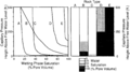
File:Capillary-pressure fig5.png ...ighly irregular vertical saturation profile. Note also the wide transition zone in rock type B caused by poor sorting of the pore throats.(1,805 × 1,011 (101 KB)) - 18:22, 14 January 2014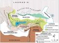
File:M106Ch13Fig01.jpg ...d and described which correspond to either a continental block or a suture zone that is amalgamated as a result of the Neo-Tethyan collision and which is m(700 × 513 (90 KB)) - 19:29, 5 July 2016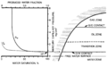
File:Fluid-contacts fig1.png ...displacement pressure (DP) on the capillary pressure curve. The transition zone is the interval with co-production of water and hydrocarbons. The fraction(1,932 × 1,198 (79 KB)) - 01:51, 14 January 2014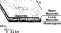
File:Seismic-inversion fig4.png A schematic diagram of a river channel zone. Copyright: the Taber area of southern Alberta. The 3-D survey was done in(841 × 461 (31 KB)) - 19:34, 14 January 2014


