Delta plain, lower
| Sandstone Depositional Environments | |

| |
| Series | Memoir |
|---|---|
| Chapter | Deltaic environments of deposition |
| Author | J. M. Coleman and D. B. Prior |
| Link | Web page |
| PDF file (requires access) | |
| Store | AAPG Store |
The lower delta plain lies within the realm of river-marine interaction and extends landward from the shoreline to the limit of tidal influence. Large areal extent of the lower delta plain is common where tidal range is large and seaward gradients of the river channel and delta are low. Most commonly in this environment, channels become more numerous and often show a bifurcating or anastomosing type of plan view pattern. Environments between distributary channels comprise the largest percentage of the lower delta plain and consist of actively migrating tidal channels, overbank splays (natural levees), interdistributary bays, bay fills (crevasse splays), marshes, and swamps. Deltas having an extremely high tidal range and an arid climate are often characterized by interdistributary evaporite or barren salt flats, where intricate networks of tidal creeks occur and are separated by broad evaporative sequences. From the standpoint of sand-body formation, the major environmental sequence consists of bay-fill deposits, which often form thin clastic wedges stacked one on top of another and separated by interdistributary bay and marsh deposits. The major environmental sequences described consist of bay-fill deposits (interdistributary bay, crevasse splay-natural levee, and marsh) and abandoned distributary-fill deposits.
Bay-fill deposits
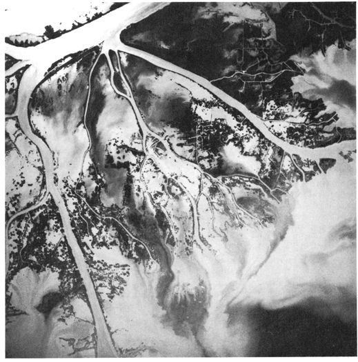
Figure 1 High-altitude air photograph of a relatively large bay-fill environment in the lower delta plain of the Mississippi River delta.[1]
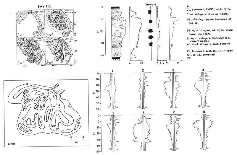
Figure 2 Summary diagram illustrating the major characteristics of the bay-fill deposits in the lower delta plain.[1]


One of the major facies associated with many deltas is the large areal extent of bay fills or crevasses that break off of main distributaries and infill the numerous interdistributary bays within the lower delta plain. These sequences form the major land areas in the lower delta plain. Crevasse deposits build into shallow bays between or adjacent to major distributaries and extend themselves seaward through a system of radial bifurcating channels similar in plan to the veins of a leaf.
The interdistributary bays into which the crevasses prograde are normally open bodies of water, often completely surrounded by marsh or distributary channels. More often, however, they partially open to the sea or connect to it by small tidal channels. Most of the bays are shallow-water bodies, rarely exceeding 7 to 8 m in depth and averaging approximately 4 m, containing brackish to marine waters. The bays are commonly elongate, with their longest dimension ranging in size from a few hundred meters to approximately 15 to 20 km. The process of crevassing or infilling has been recorded historically in many cases.[2] Each bay fill forms initially as a break in the major distributary channel during flood stage, gradually increases in flow through successive floods, reaches a peak of maximum deposition, wanes, and becomes inactive. As a result of subsidence, the crevasse system is inundated by marine waters, reverting to a bay environment, and thus completing a sedimentary cycle.
The mass of sediment resulting from crevassing process ranges in thickness from 3 to 15 m, this sequence forming in a period of approximately 100 to 150 years. Although the individual bay fills are relatively thin, continuing subsidence and repeating of similar processes result in stacking of one bay fill on top of another, eventually building a thick sequence of lower delta-plain deposits.
Figure 1 shows a high-altitude photograph of a relatively large bay-fill environment in the lower delta plain of the Mississippi River delta. This particular crevasse, Cubits Gap Crevasse, occurred in 1862, when a break in the levee diverted some 6 to 8% of the Mississippi River water through the crevasse opening.[3] By 1870 only a small number of low shoals were visible on the maps. By 1903 essentially the entire bay area had been infilled with crevasse-splay or bay-fill sediments. Since that time, subsidence and deterioration have resulted because of a lack of clastic sedimentation, and presently only the major distributary patterns are obvious on high-altitude photographs.
Most of the former land surface has now reverted to extremely shallow-water bays, and in approximately 30 to 40 years the entire landmass will have subsided below sea level and the environment will have reverted to an interdistributary bay. The upper left diagram of Figure 9 illustrates, by a series of historic maps, development of the West Bay fill. The break in the major Mississippi channel occurred in 1839, and maps from that time show water depths of 7 to 10 m in the adjacent bay. After the initial levee break, coarse sediment was dumped subaqueously in the vicinity of the break, and no new sub-aerial land developed. However, with continued deposition and a general shoaling in the bay near the break, a bifurcating channel pattern and infilling of the bay sequence developed rapidly This stage of development is illustrated by the map in 1875; most of the channels were still actively prograding, and nearly the entire bay had been filled with sediments or a regressive sequence of delta deposits.
The map from 1922 shows that many of the channels had been abandoned. They had prograded far enough seaward to lose their gradient advantage, and only a few of the major channels continued to deliver sediments to the bay. Much of the newly exposed land had been converted into luxuriant marsh growth, and organic-rich clays were capping the top of the regressive sequence. With time, plant growth could no longer maintain its productivity because of encroaching marine waters, and slowly the marsh began to break into numerous small lakes and bays. Wind-generated waves in the shallow bays, coupled with subsidence, began to destroy the marsh surface, and by 1958 much of the original land buildout had subsided below sea level, the area reverting to a bay.
By 1978 the entire region had been inundated by marine waters, and the West Bay complex had reverted to a shallow-marine interdistributary environment. Given time, another crevasse will eventually form on the bank of the Mississippi and another period of progradation will ensue, again filling the interdistributary bay with detrital sediments. It is this process of repeated filling, alternating with periods of marsh destruction, that forms the bulk of cyclic deposits in the lower delta plain.

The upper right-hand diagram in Figure 2 illustrates the typical vertical sequence resulting from bay infilling. As can be seen, it is a coarsening-upward sequence, with shallow brackish water clays and organic debris forming the lower part and well-sorted clastics forming the upper sand body. The upper unit is essentially distributary-mouth bar deposits associated with the prograding distributary. The lowermost part of the bay fill generally consists of alternating silts and silty clays, with the clays often showing silt- and sand-infilled burrows (Figure 3A).
With continued and increasing sedimentation in the interdistributary bay, coarser particles and more rapid deposition occur. Then silty and sandy stringers begin to intercalate with silty clays. Burrowing is generally reduced (Figure 3B). As the distributary system advances farther into the bay, delivery of coarser grained clastics begins at the site of the vertical section, and often sands and silty sands alternate with thin silty clay laminations. Graded bedding and some small-scale climbing ripple structures are the most common types of lamination (Figure 3C). As the distributary mouth progrades closer to the site of the vertical section, small-scale cross-bedding and occasionally organic trash within the sandy deposits become the most common types of stratification (Figure 3D).
The lower part of the distributary-mouth bar itself is often characterized by cross-bedded sands alternating with sandy silts and silty clays. In general little or no scouring is evident in this part of the bay-fill sequence (Figure 3E, F). The bulk of the sand deposit associated with the advancing distributary-mouth bar is composed of cross-stratified sands and sandy silts, displaying a wide variety of climbing ripples and small-scale festoon-type cross-bedding (Figure 3G, H). A high mica content and transported organic debris along bedding planes are common in this part of the vertical sequence.
Once the distributary-mouth bar has prograded across the site of the vertical section, it is capped by small over-bank crevasse splays, which often display alternating silt, sand, and clay units, the silts and sands including well-developed small-scale ripple laminations (Figure 3I). In some instances, scour into the underlying deposits is apparent; however, the scour planes are of extremely low angle. The uppermost unit capping the bay-fill sequence is essentially an interdistributary bay or a marsh deposit. Interdistributary bays normally consist of highly burrowed silts and silty clays, whereas marsh deposits generally display a sequence of highly burrowed organic clays (Figure 3J). In some deposits iron carbonate or siderite nodules are common, and in most cases pyrite is abundant, replacing plant debris.
The lower two diagrams (Figure 2) illustrate an isopach map of a bay-fill sequence and variations in log response that can occur within such a sand body. The isopached sand body generally displays a fan-shaped wedge, with the thickest sands generally being found near the initial break in the distributary channel. Often, sands in this vicinity display a sharp base scoured into the underlying interdistributary bay and marsh deposits. Away from the initial break, however, the typical coarsening-upward sequence (or inverted bell-shaped logs) becomes the most common type of log response. Within the overall sand body there are areas where sands have not accumulated to any great thickness, and therefore zones (bore hole 2) in which virtually no sand can be found and the entire sequence consists of interdistributary-bay silts and clays, grading upward to marsh deposits.
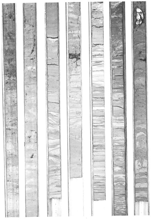
Figure 4 Cored boring through the West Bay fill sequence. Boring is located near the distal end of the bay infill. Diameter of core is 8 cm (3 in.).[1]
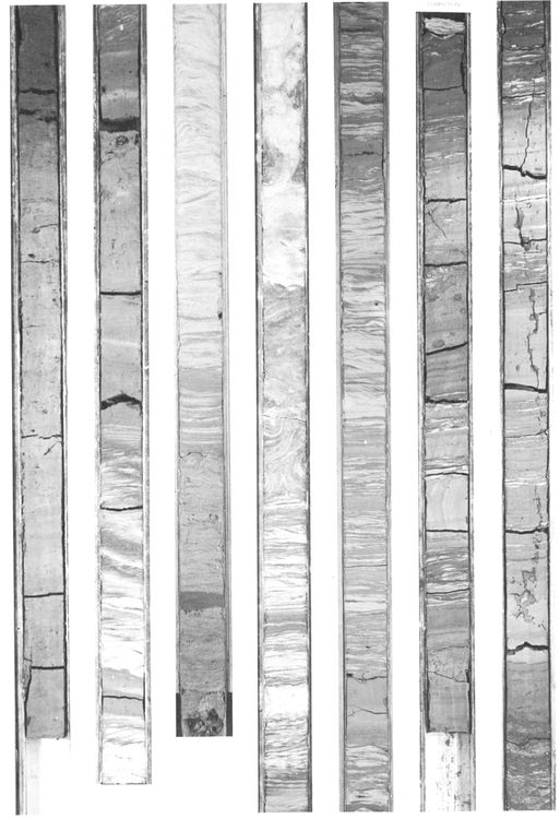
Figure 5 Cored boring through the West Bay bay fill sequence. Boring is located in central part of the bay-fill sequence. Diameter of core is 8 cm (3 in.).[1]


Figure 4 and Figure 5 illustrate a continuous core through the West Bay complex. Location of the boring shown in Figure 4 is toward the outer fringes of the sand body, and the distributary-mouth-bar sands become much thicker and are more apparent in the cored borings. Comparison of these continuous cored borings with the vertical profile in Figure 2 indicates that stratification from the lower part of the bay fill to the upper part changes from parallel laminated and burrowed clays at the base to a higher and higher percentage of those structures associated with current flow near the top of the infilled sequence. Because of position within the overall bay fill, however, thickness of the sand body can vary considerably.
Abandoned distributary deposits

The distributary channel is the natural flume which accommodates and directs a part of the water and sediment discharged from the parent river system to the receiving basin. In most deltas, the distributary channels are rather stable and do not display a tendency toward lateral migration, thereby preventing the formation of point-bar or meander-belt deposits. In some deltas, for example, with high bedload streams or in those environmental settings where tidal range is high, migration of the distributary channel can take place, resulting in formation of deposits similar to channel deposits described in the upper delta plain.
Although little research has been conducted, the lack of channel migration in the lower delta plain is undoubtedly due to the fact that most river channels scour down through their distributary-mouth-bar deposits into underlying marine clays. This scouring provides an entrenchment of the distributary channel with minimal tendencies for lateral migration. Active distributary channels vary considerably in size, some only a few meters wide and 1 to 2 m deep, and others of a large major river delta system with channels reaching 1 km in width and 30 m in depth. Depth within the channel decreases rapidly as the river-mouth bar is approached, and water depths over most distributary-mouth bars rarely exceed 3 m.
Abandonment of a distributary channel is an extremely complex process, and in many areas is simply an accident. Log jams, loss of gradient advantage, infilling during a catastrophic period (such as a hurricane), or changes in the upstream part of the river will cause the channel to deteriorate and infill. Deprived of an active influx of sediment and water, the channel will then undergo an infilling process in which only local sediments derived from both upstream and downstream will infill the abandoned hole in the ground. The lower parts of the channel are commonly filled with poorly sorted sands and silts containing an abundance of transported organic debris. As a channel shoals, the water becomes more stagnant, and lower current velocities are maintained; soon, fine-grained material begin to infill the channel proper. With time and continued subsidence the channel often fills entirely with fine-grained, poorly sorted sediments. Organic debris, logs, and clays with extremely high water content often form the upper part of the channel fill. Thus in many deltaic regions of low tides and high suspended sediment load, no process is available to infill the channels with sand or other coarse debris.

This aspect of the infilling of a distributary channel is schematically illustrated in the upper left diagram of Figure 6. This diagram illustrates the infilling of two distributary channels, showing the channel deposits themselves cut through the major sand body, which is essentially the distributary-mouth bar.

The upper right diagram, based on numerous cores through abandoned channels, illustrates a typical vertical sequence. The major characteristic is the erratic nature of the thin sand and silt layers that alternate with clays, forming the bulk of the deposit. Core hole after core hole indicates no orderly plan to the infilling process. About the only common attribute is a tendency for any substantial amount of sand (should substantial amounts be present) to concentrate near the base of the channel or at points where the channel bifurcates. Because of this lack of organized infilling it is often difficult to pick the base of the channel itself. Generally the only applicable method is use of faunal remains, because most of the distributary channels scour down into marine deposits, whereas clays infilling the channel generally contain little or no fauna and virtually no open marine fauna. Near the base of the infilled channel, often erratic and contorted clay layers are concentrated as clast within the sand body (Figure 7A). Within the deposited sands themselves, contorted structures are very common. Slump-type structures, distorted bedding, clay infills, and occasionally fairly persistent layers of organic trash sandwiched between sand layers are also common. Figure 7B illustrates some of the contorted bedding probably associated with localized slumps within a channel-fill deposit. Silts and silty clays that are deposited in the central part of the channel fill often display thin silty and sandy layers that intercalate with highly burrowed clays. Most commonly the sandy laminations display extremely sharp upper and lower surfaces (Figure 7C). Convolute laminations and other types of distorted bedding such as flow rolls, ball and pillow structures, etc. (Figure 7D), are common within the sand bodies. The uppermost part of the fill consists primarily of organic-rich clays (Figure 7E) that generally show intense root burrowing. Occasionally, thin seams of shell debris and silt-infilled animal burrows can be detected.
Although grain size has a general tendency to show a fining-upward sequence within any one sandy unit, in some deposits there is virtually no change in grain size. Dip angles can also be extremely erratic, resulting primarily from the large number of disturbed and distorted structures found within the channel-fill deposits. Undoubtedly, the rapidity of the infilling process and extremely high porewater content of the clays and silts are responsible for the large amount of distorted bedding.
Figure 8 is a continuously cored boring through an old distributary channel that existed off Southwest Pass, Mississippi River delta, in the early 1800s. The channel on old maps was approximately 9 to 10 m deep and about 100 to 110 m wide. The base of the channel in the cored boring is identified by the letter A and occurs at a depth below mean sea level of 10.5 m. The clays directly below this scour plane, where burrowing is present, contain marine microfaunal remains. Just above the scour surface is a sand approximately 1 m thick. It contains fairly well-sorted fine- to medium-grained sands displaying small-scale current structures. Organic trash and other debris are common along the bedding planes.
Above this unit are a series of alternating sands, silty clays, and clays displaying a large amount of contorted bedding, load casting, and small-scale slumping (Figure 8). The central part of the fill consists of silty clays alternating with thin silt laminations. Although not especially well displayed in this cored boring, one of the more characteristic features of the laminations within abandoned channels is the extremely sharp nature of both the upper and lower bounding planes of silt and sand laminations within the overall fine-grained channel fill. Graded bedding is rarely observed. The uppermost section of the fill in this distributary channel consists of fine-grained sirs and silty clays containing large amounts of organic debris along the bedding planes. Distorted laminations within the clays and silty clays are apparent (uppermost cores, Figure 8). The uppermost meter in the abandoned channel in Figure 8 consisted primarily of organic-rich clays and peats, which, because of their extremely high water content, were unable to be preserved and adequately cored and thus are not illustrated in this boring.
The lowermost two diagrams in Figure 6 illustrate an isopach map and variations in electric-log response across an abandoned channel-fill sequence. As shown in the isopach map, if any sand buildup is apparent in the abandoned channel, it most commonly occurs where the channel tends to display a bifurcating nature. Often 5 to 8 m of sand will be concentrated in this particular part of the channel fill. Electric logs generally give extremely erratic and ragged appearances in the fill itself. The only significant buildup of sand generally occurs near the base of the channel. Sand layers above this unit often show little high lateral continuity, and logs only a few hundred meters apart cannot be accurately correlated.
Further Reading
Literature on bay-fill sequences.
- Arndorfer, D. J., 1973, Discharge patterns in two crevasses of the Mississippi River delta: Marine Geology, v. 15, p. 269-287.
- Bagans, B. P., J. C. Horne, and J. C. Ferm, 1975, Carboniferous and Recent Mississippi lower delta plains: Gulf Coast Assoc. Geol. Soc. Trans., v. 25, p. 183-191.
- Coleman, J. M., 1976, Deltas: Processes of deposition and models for exploration: Continuing Education Publ. Co., Champaign, IL (now available from Burgess Publishing Co.), 102 p.
- Coleman, J. M., and L. D. Wright, 1975, Modern river deltas: variability of processes and sand bodies: in M. L. Broussard, ed., Deltas, 2nd ed:, Houston Geol. Soc., p. 99-150.
- Coleman, J. M., and S. M. Gagliano, 1965, Sedimentary structures--Mississippi delta plain: in G. V. Middleton, ed., Primary sedimentary structures and their hydrodynamic interpretation--a symposium: SEPM Spec. Pub. 12, p. 133-148.
- Coleman, J. M., S. M. Gagliano, and J. E. Webb, 1964, Minor sedimentary structures in a prograding distributary: Marine Geol., v. 1, p. 240-258.
- Dapples, E. C., and M. E. Hopkins, 1969, Environments of coal deposition: Geol. Soc. America Spec. Paper no. 114, 204 p.
- Donaldson, A. C., 1967, Deltaic sands and sandstones: in Guidebook, p. 31-62h, Symposium on recently developed geologic principles and sedimentation of the Permo-Pennsylvania of the Rocky Mountains: Wyoming Geol. Assoc. 20th Ann. Field Conf., Casper, Wyoming, 1966.
- Fisher, W. L., and J. H. McGowen, 1967, Depositional systems in the Wilcox Group of Texas and their relationship to oil and gas: Gulf Coast Assoc. Geol. Soc. Trans., v. 17, p. 105-125.
- Fisk, H. N., et al, 1954, Sedimentary framework of the modern Mississippi delta: Jour. Sed. Petrology, v. 24, p. 76-99.
- Hobday, D. K., and David Mathews, 1975, Late Paleozoic fluviatile and deltaic deposits in the northeast Karroo Basin, South Africa: in M. L. Broussard, ed., Deltas, models for exploration, 2nd ed:, Houston Geol. Soc., p. 457-469.
- Horne, J. C., et al, 1978, Depositional models in coal exploration and mine planning in Appalachian region: AAPG Bulletin, v. 62, no. 12, p. 2379-2411.
- LeBlanc, R. J., 1972, Geometry of sandstone reservoir bodies: in T. D. Cook, ed., Underground waste management and environmental implications: AAPG Memoir 18, p. 133-190.
- Humphreys, M., and G. M. Friedman, 1975, Upper Devonian Catskill deltaic complex in north-central Pennsylvania: in M. L. Broussard, ed., Deltas, models for exploration, 2nd ed: Houston Geol. Soc., p. 369-379.
- McEwen, M. C., 1963, Sedimentary facies of the Trinity River delta: PhD dissertation, Rice Univ., Houston, Texas, 113 p.
- Morgan, J. P., 1967, Ephemeral estuaries of the deltaic environment: in G. H. Lauff, ed., Estuaries: Am. Assoc. Adv. Sci. monograph, p. 115-120.
- Reineck, H. E., and I. B. Singh, 1967, Primary sedimentary structures in the Recent sediments of the Jade, North Sea: Marine Geol., v. 5, p. 227-235.
- Russell, R. J., 1936, Physiography of the lower Mississippi River delta: in Reports on the geology of Plaquemines and St. Bernard Parishes: Louisiana Dept. Cons. Geol. Bull. 8, p. 3-193.
- Scruton, P. C., 1955, Sediments of the eastern Mississippi Delta: in Finding ancient shorelines: SEPM Spec. Pub. 3, p. 21-51.
- Visher, G. S., S. B. Ekebafe, and J. Rennison, 1975, The Coffeyville Formation (Pennsylvanian) of northeastern Oklahoma, a model for an epeiric sea delta: in M. L. Broussard, ed., Deltas, models for exploration, 2nd ed: Houston Geol. Soc., p. 381-397.
- Welder, F. A., 1959, Processes of deltaic sedimentation in the lower Mississippi River: Tech. Rept. 12, Coastal Studies Inst., Louisiana State Univ., Baton Rouge, 90 p.
See also
References
- ↑ 1.0 1.1 1.2 1.3 1.4 1.5 1.6 1.7 Coleman, J. M., and D. B. Prior, 1981, Deltaic environments of deposition in P. A. Scholle and D. Spearing, eds., Sandstone depositional environments: AAPG Memoir 31, p. 139-178.
- ↑ Coleman, J. M., and S. M. Gagliano, 1964, Cyclic sedimentation in the Mississippi River deltaic plain: Gulf Coast Assoc. Geol. Socs. Trans., v. 14, p. 67-80.
- ↑ Welder, F. A., 1959, Processes of deltaic sedimentation in the lower Mississippi River: Tech. Rept. 12, Coastal Studies Inst., Louisiana State Univ., Baton Rouge, 90 p.
External links
| find literature about Delta plain, lower |