East Breaks hydrocarbon migration model
| Exploring for Oil and Gas Traps | |

| |
| Series | Treatise in Petroleum Geology |
|---|---|
| Part | Critical elements of the petroleum system |
| Chapter | Sedimentary basin analysis |
| Author | John M. Armentrout |
| Link | Web page |
| Store | AAPG Store |
Vertical migration path
Petroleum generated at depth, either from the middle Miocene as suggested by Dow et al.[1] or the lower Tertiary or Upper Jurassic as suggested by Gross et al.[2] had to move vertically within the East Breaks 160-161 minibasin to charge the known gravity-flow sandstone reservoirs. The deepwater lowstand gravity-flow reservoir sandstones are separated by hemipelagic mudstones deposited during condensed sedimentation of each cycle. Migration through matrix porosity of these effective top-seal mudstones is highly unlikely. Thus, vertical migration along faults is the most probable avenue. Episodic movement on the faults would result in multiple phases of migration and could account for the observed mix of oils of different maturities within the same structure[3] and the mix of biodegraded and nonbiodegraded oil in the same reservoir (Dow et al.;[1] see also Anderson[4] and Anderson et al[5] for migration model).
Lateral migration path
Once the petroleum has migrated up the fault to the porous and permeable sandstone, it could move laterally up-structure within the continuous sand beds until it accumulated within structural closure. The driving force behind the migration is most likely a combination of several factors, including fluid buoyancy, formation pressure trends, and salinity gradients. Similar migration patterns have been suggested by Hanor and Sassen.[6]
Southern Louisiana model
Hanor and Sassen[6] present data from Cretaceous and Tertiary strata in southern Louisiana for aqueous fluid flow from deep, geopressured sediments vertically upward to normally hydropressured zones. This migration is interpreted to occur through fractures and faults rather than through matrix porosity.
The following figure is a regional cross section summarizing in a qualitative, conceptual way the regional hydraulic flow regimes of the Louisiana Gulf Coast above a depth of depth::20,000 ft (6096 m). The uppermost regime consists of low-salinity, meteoric water driven gulfward by differences in topographic elevation. The deepest regime consists of moderately saline water driven upward and laterally by excess fluid pressures. In between is a hydraulic regime in which lateral and vertical flow of saline brines is taking place—in part in response to differences in fluid density caused by spatial variations in temperature and salinity. The dissolution of salt plays a critical role in driving fluid flow in this region. Arrows show possible pathways of fluid flow.
GOM Neogene model
Patterns of migration in the offshore Gulf of Mexico Neogene strata suggest migration avenues similar to the southern Louisiana model. Lovely and Ruggiero (personal communication, 1995) integrated multiple data sets, including geochemical analysis of cores and sea-floor acoustic impedance patterns and orthocontouring of structure maps, and formulated a hypothesis for petroleum migration.
The figure below is a north-south 3-D seismic reflection profile illustrating three possible hydrocarbon migration pathways and related sea-bed features. They concluded that the primary migration pathway involves migration up from geopressured ][source rock]]s along the sediment/salt interface with sea-floor seepage forming hydrates and providing nutrients to carbonate producing organisms (1). A secondary pathway involves redirection of some of the petroleum from the sediment/salt interface laterally into sand-rich carrier beds (2). Pathway 3 consists of a fault intersection of either pathway 1 or 2 and the vertical migration along fault-associated fracture conduits with possible formation of fault scarp amplitude halos at intersected reservoirs and sea-floor hydrate/carbonate mounds.
East breaks migration model
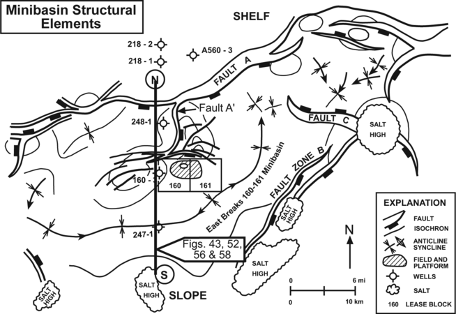
Figure 2 Structural elements that define the East Breaks 160-161 minibasin. From Armentrout et al.[8] Courtesy Springer-Verlag.


Using these hypothetical migration avenues, a migration pathway model has been constructed for the East Breaks 160-161 minibasin. Dow et al.[1] present temperature information, indicating an elevated thermal gradient in the block 160-A-29 well where it is in close proximity to salt. Additionally, the A-29 borehole mud weight of weight::13.5 lb below depth::5,000 ft (1524 m) and weight::15.7 lb below depth::7,000 ft (2134 m) and mathematical modeling suggest probable overpressure and undercompacted sediments below a depth of depth::10,000 ft (3048 m). The consequent thermal and geopressure gradient would drive fluid flow from depth up migration pathways into available reservoirs.
Figure 1 is a north-south seismic section showing the hypothetical model for migration pathways within the East Breaks 160-161 field (see Figure 2 for location). Fault conduits allow upward migration from high-pressure, thermally mature probable source rocks into the intersected gravity-flow sandstone reservoirs at the Glob alt, Hyal B, and Trim A horizons. The Glob M horizon between the Glob alt and Hyal B horizons is productive from sands in the East Breaks 158-159 field length::6 mi (about 10 km) to the west within the same minibasin.
The probable fault-plane migration pathway of the East Breaks 160-161 field offsets the sea floor and locally has associated mud volcanoes along the fault scarp. Despite these observations of recent and/or current fault movement and fluid discharge, the absence of hydrates and biogenic carbonate buildups suggests that hydrocarbons are not reaching the shallowest section.
Seal rocks consist of condensed-section mudstones that provide effective top seal for each lowstand gravity-flow sandstone. These condensed-section mudstones are often thick enough to provide effective lateral seal except where faults offset juxtaposed sandstones.
See also
- East Breaks petroleum system
- East Breaks trap formation
- East Breaks geochemistry
- East Breaks hydrocarbon generation model
- East Breaks hydrocarbon accumulation model
- East Breaks critical moment
References
- ↑ 1.0 1.1 1.2 Dow, W. G., M. A. Yukler, J. T. Senftle, M. C. Kennicutt, and J. M. Armentrout, 1990, Miocene oil source beds in the East Breaks basin, Flex-Trend, offshore Texas: Proceedings, Gulf Coast Section SEPM 9th Annual Research conference, p. 139–150.
- ↑ Gross, O. P., K. C. Hood, L. M. Wenger, and S. C. Harrison, 1995, Seismic imaging and analysis of source and migration within an integrated hydrocarbon system study, northern Gulf of Mexico basin: Abstracts, 1st Latin American Geophysical conference, p. 1–4.
- ↑ Schanck, J. W., C. C. Cobb, and M. L. Ivey, Jr., 1988, East Breaks 160 field on the offshore Texas shelf edge: a model for deepwater exploration and development: Proceedings, 20th Annual Offshore Technology conference, p. 157–162.
- ↑ Anderson, R. N., 1993, Recovering dynamic Gulf of Mexico reserves and the U., S. energy future: Oil & Gas Journal, 26 April 1993, p. 85–88, 90–92.
- ↑ Anderson, R. N., P. Flemings, S. Losh, J. Austin, and R. Woodhams, 1994, Gulf of Mexico growth fault drilled, seen as oil, gas migration pathway: Oil & Gas Journal, 6 June 1994, p. 97–104.
- ↑ 6.0 6.1 Hanor, J. S., and R. Sassen, 1990, Evidence for large-scale vertical and lateral migration of formation waters, dissolved salt, and crude oil in the Louisiana Gulf Coast: Proceedings, Gulf Coast Section SEPM 9th Annual Research conference, p. 283–296.
- ↑ Lovely and Ruggiero, 1995, personal communication
- ↑ Armentrout, J. M., S. J. Malacek, P. Braithwaite, and C. R. Beeman, 1991, Seismic facies of slope basin turbidite reservoirs, East Breaks 160-161 field: Pliocene-Pleistocene, northwestern Gulf of Mexico, in P. Weimer and M. J. Link, eds., Seismic facies and sedimentary processes of submarine fans and turbidite systems: New York, Springer-Verlag, p. 223-239.
External links
| find literature about East Breaks hydrocarbon migration model |