Ellesmerian(!) petroleum system
| Exploring for Oil and Gas Traps | |

| |
| Series | Treatise in Petroleum Geology |
|---|---|
| Part | Traps, trap types, and the petroleum system |
| Chapter | Petroleum systems |
| Author | Leslie B. Magoon, Edward A. Beaumont |
| Link | Web page |
| Store | AAPG Store |
The Ellesmerian(!) petroleum system of the North Slope, Alaska, contains approximately 77 billion bbl of oil equivalent.[1] The age of the reservoir rock ranges from Mississippian to early Tertiary. Total organic carbon and assumed hydrogen indices from the marine shale source rocks indicate the mass of petroleum generated to be approximately 8 trillion barrels of oil[1] These estimates indicate about 1% of the generated hydrocarbons are contained in known traps. More importantly, the U.S. Geological Survey estimates another 1% is trapped in undiscovered accumulations in the Ellesmerian(!) petroleum system.[1]
Geologic setting[edit]
The North Slope evolved from a passive continental margin to a foredeep during the Jurassic. Prior to the Jurassic, Paleozoic and Mesozoic strata were deposited on a passive continental margin. They consist of Carboniferous platform carbonate rocks and Permian to Jurassic shelf to basinal siliciclastic rocks. The passive margin converted to a foredeep during the Jurassic and Cretaceous when it collided with an ocean island arc. The foredeep began to fill with sediments in the Middle Jurassic and continues to do so.
The foredeep basin fill consists of orogenic sedimentary materials eroded from the nearby ancestral Brooks Range that were deposited as a northeasterly prograding wedge of non-marine, shallow marine, basin-slope, and basin conglomerates, sandstones, and mud-stones.
Petroleum system map[edit]
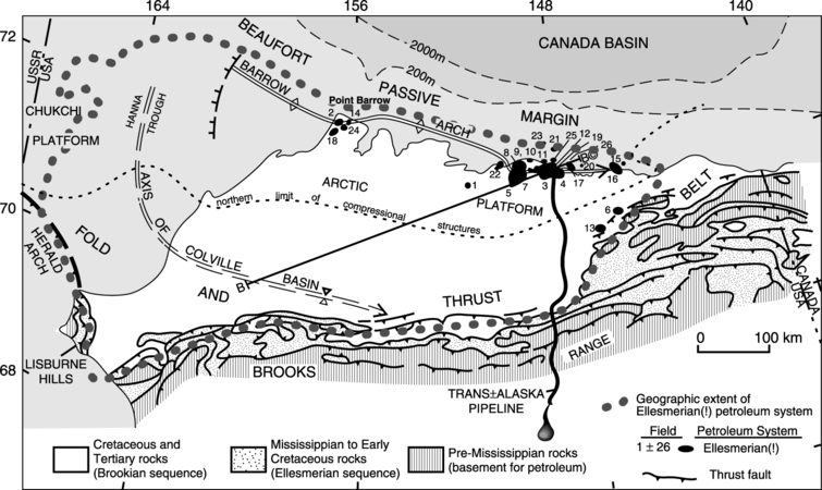
Figure 1 Ellesmerian(!) petroleum system geographic extent. From Bird.[1]

Figure 1 shows the Ellesmerian(!) petroleum system geographic extent. The limit is determined by the extent of the contiguous active source rock and the related petroleum accumulations.
Petroleum system maturity map[edit]
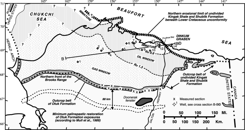
Figure 2 thermal maturity of the two main Ellesmerian(!) petroleum system source rocks, the Shublik Formation and the Kingak Shale. From Bird.[1]

Figure 2 shows the thermal maturity of the two main Ellesmerian(!) petroleum system source rocks, the Shublik Formation and the Kingak Shale. Note that Ellesmerian(!) petroleum system traps (shown in Figure 1) are mostly located above immature source rocks.
Petroleum system cross section[edit]
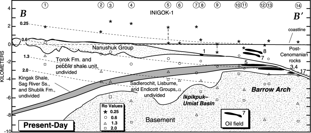
Figure 3 Major structural-stratigraphic elements, the occurrence of oil fields, elevation of selected vitrinite reflectance values, and reflectance isograds. From Bird.[1]

The cross section of the Ellesmerian(!) petroleum system (Figure 3) shows major structural-stratigraphic elements, the occurrence of oil fields, elevation of selected vitrinite reflectance values, and reflectance isograds. For the location, refer to Figure 1.
Burial history chart[edit]
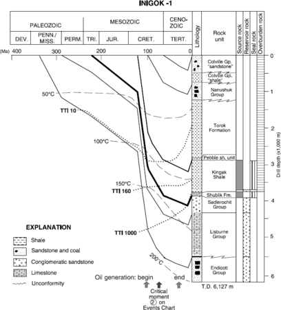
Figure 4 Analysis of the burial history chart of the Inigok 1 well. From Bird.[1]

Analysis of the burial history chart of the Inigok 1 well (Figure 4) and other burial history charts indicates peak petroleum generation (the critical moment) probably occurred in Late Cretaceous time (approximately 75 Ma) in the western North Slope and in early Tertiary time (approximately 50 Ma) in the central and eastern part of the North Slope. Also, note the large increase in the rate of sedimentation during the Early Cretaceous.
Oil-source rock correlation[edit]

Biological marker analysis (Figure 5A) from the main reservoir rock, Sadlerochit Group, of Prudhoe Bay field shows that the oil originated from the Shublik Formation, the Kingak Shale, and the Hue Shale. Carbon isotopic composition comparisons (Figure 5B) indicate that Shublik and Kingak share similar 13C values with oil from the Prudhoe Bay field, whereas the Hue Shale does not.
Petroleum system events chart[edit]
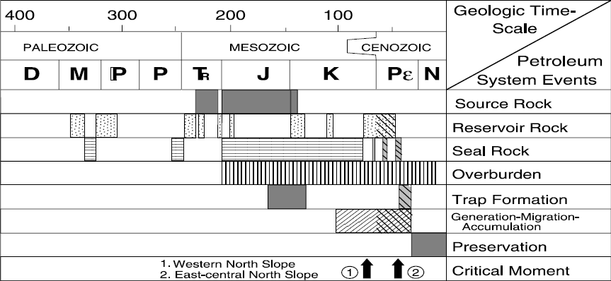
Figure 6 Events chart for the Ellesmerian(!) petroleum system. From Bird.[1]

Figure 6, an events chart for the Ellesmerian(!) petroleum system, indicates when its elements and processes occurred. The cross-hatched pattern shows the estimated time of the tilting of the Barrow Arch, which resulted in remigration of petroleum from older to younger (early Tertiary) reservoir rocks.
Size of the petroleum system[edit]
The size of the Ellesmerian(!) petroleum system, shown in the table below, is determined by the total volume of in-place petroleum that originated from the pod of active Ellesmerian(!) petroleum system source rock. The in-place petroleum is determined from the recoverable petroleum and, where possible, surface deposits, seeps, and shows. In the table below, trap type A is structural, B is stratigraphic, and C is combination.
| Map ID | Accumulation | Res. depth (m) | Trap type | In Place | Cum. Prod. | Reserves | |||
|---|---|---|---|---|---|---|---|---|---|
| Oil (Bbbl) | Gas (Tcf) | Oil (Mbbl) | Gas (Bcf) | Oil (Mbbl) | Gas (Bcf) | ||||
| 1 | Fish Creek | 915 | B? | <<1 | — | — | — | ? | ? |
| 2 | South Barrow | 685 | A | — | <<1 | — | 20 | — | 5 |
| 3 | Prudhoe Bay | 2440 | C | 23 | 27 | 7026 | 11951 | 2700 | 23441 |
| 4 | Prudhoe Bay | 2685 | C | 3 | 3 | 64 | 382 | 101 | 406 |
| 5 | Kuparuk River | 1830 | C | 4 | 2 | 723 | 814 | 780 | 634 |
| 6 | Kavik | 1435 | A | — | <1 | — | — | — | ? |
| 7 | West Sak | B? | 20 | <<1 | 1 | — | — | — | |
| 8 | Ugnu | B? | 15 | — | — | — | — | — | |
| 9 | Milne Point | A | <1 | <<1 | — | — | — | ? | |
| 10 | Milne Point | A | <1 | <<1 | 16 | 6 | 84 | ? | |
| 11 | Gwydyr Bay | A | <1 | <<1 | — | — | 60 | ? | |
| 12 | North Prudhoe | A | <1 | <<1 | — | — | 75 | ? | |
| 13 | Kemik | 2625 | A | — | <1 | – | — | — | ? |
| 14 | East Barrow | A | — | <<1 | — | 6 | — | 6 | |
| 15 | Flaxman Island | 3810 | B? | ? | ? | — | — | ? | ? |
| 16 | Point Thomson | 3960 | C | <1 | 6 | — | — | 350 | 5000 |
| 17 | Endicott | C | 1 | <2 | 118 | 127 | 272 | 907 | |
| 18 | Walakpa | B | — | <<1 | — | — | – | ? | |
| 19 | Niakuk | C | <1 | <<1 | — | — | 58 | 30 | |
| 20 | Tern Island | C | ? | ? | — | — | ? | ? | |
| 21 | Seal Island | A | <1 | <1 | — | — | 150 | ? | |
| 22 | Colville Delta | 1950 | C? | ? | ? | — | — | ? | ? |
| 23 | Sandpiper | A | ? | ? | — | — | ? | ? | |
| 24 | Sikulik | A | — | <<1 | — | — | — | ? | |
| 25 | Point McIntyre | C | 1 | ? | — | — | 300 | ? | |
| 26 | Sag Delta North | C | <1 | <<1 | 2 | 2 | ? | ? | |
| TOTALS | >67 | >39 | 7950 | 13308 | 4930 | 30423 | |||
See also[edit]
References[edit]
- ↑ 1.0 1.1 1.2 1.3 1.4 1.5 1.6 1.7 1.8 Bird, K. J., 1994, Ellesmerian(!) petroleum system, North Slope, Alaska, USA, in L. B. Magoon, and W. G. Dow, eds., The Petroleum System—From Source to Trap: AAPG Memoir 60, p. 339–358.
- ↑ Seifert, W. K., J. M. Moldowan, and R. W. Jones, 1980, Application of biological marker chemistry to petroleum exploration: Proceedings of the 10th World Petroleum Congress, Bucharest, p. 425-440
- ↑ Sedivy, R. A., I. E. Penfield, H. I. Halpern, R. J. Drozd, G. A. Cole, and R. Burwood, 1987, Investigation of source rock–crude oil relationships in the northern Alaska hydrocarbon habitat, in I. Tailleur, and P. Weimer, eds., Alaskan North Slope Geology: Pacific Section SEPM Book 50, p. 169–179.
External links[edit]
| find literature about Ellesmerian(!) petroleum system |