File:M115CH02FG03.jpg
Original file (700 × 767 pixels, file size: 157 KB, MIME type: image/jpeg)
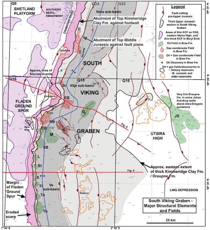
Main structural elements of the South Viking Graben and its flanks. The extent of the thick Middle-Upper Jurassic graben fill is defined by the limits of the KCF-Draupne Formation. Unshaded areas on the Fladen Ground Spur and Utsira High have pre-Upper Jurassic rocks beneath Cenozoic or Cretaceous strata (with very thin, <approximately 2 m [6.6 ft], KCF-Draupne Formation in a few wells). The locations of Upper Jurassic oil and gas condensate fields within the graben are shown with solid fill. Fields with Cenozoic reservoirs are shown with black outlines; fields and discoveries with Middle Jurassic and older reservoirs are shown with orange outlines. Most faults shown are derived from mapping by some of the current authors, but a few in the southeast portion of the map are from Zanella et al. (2003). Bi = Birch; Br = Braemar; CB = Central Brae; D = Devenick; EB = East Brae; G = Gudrun; JS = John Sverdrup; K = Kingfisher; L = Larch; M = Miller; NB = North Brae; SB = South Brae; S = Sycamore; Th = Thelma; Ti = Tiffany; To = Toni. From AAPG Memoir 115—Rift-Related Coarse-Grained Submarine Fan Reservoirs: The Brae Play, South Viking Graben, North Sea, Chapter 2.
File history
Click on a date/time to view the file as it appeared at that time.
| Date/Time | Thumbnail | Dimensions | User | Comment | |
|---|---|---|---|---|---|
| current | 21:29, 10 January 2019 | | 700 × 767 (157 KB) | Molyneux (talk | contribs) | Main structural elements of the South Viking Graben and its flanks. The extent of the thick Middle-Upper Jurassic graben fill is defined by the limits of the KCF-Draupne Formation. Unshaded areas on the Fladen Ground Spur and Utsira High have pre-Upper... |
You cannot overwrite this file.
File usage
The following page uses this file: