File:M115CH10FG02.jpg
Jump to navigation
Jump to search

Size of this preview: 680 × 600 pixels. Other resolutions: 272 × 240 pixels | 1,283 × 1,132 pixels.
Original file (1,283 × 1,132 pixels, file size: 1.55 MB, MIME type: image/jpeg)
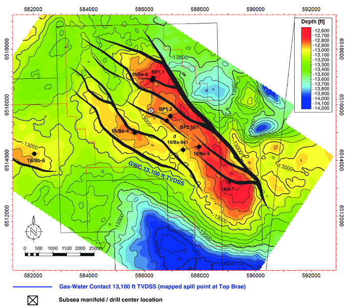
Top Brae reservoir depth structure map showing the location of the exploration, appraisal, and production wells. Also shown is the 13,100 ft (3993 m) TVDSS depth contour corresponding to the gas–water contact at the top of the Brae 1 reservoir interval with structural spill point to the west. Depth contours shown are in 100 ft (30 m) TVD increments. Area of map is shown in Figure 1. From AAPG Memoir 115—Rift-Related Coarse-Grained Submarine Fan Reservoirs: The Brae Play, South Viking Graben, North Sea, Chapter 10.
File history
Click on a date/time to view the file as it appeared at that time.
| Date/Time | Thumbnail | Dimensions | User | Comment | |
|---|---|---|---|---|---|
| current | 18:38, 17 January 2019 | | 1,283 × 1,132 (1.55 MB) | Molyneux (talk | contribs) | Top Brae reservoir depth structure map showing the location of the exploration, appraisal, and production wells. Also shown is the 13,100 ft (3993 m) TVDSS depth contour corresponding to the gas–water contact at the top of the Brae 1 reservoir interv... |
You cannot overwrite this file.
File usage
The following page uses this file: