File:Subsurface-maps fig5.png
Jump to navigation
Jump to search

Size of this preview: 369 × 599 pixels. Other resolutions: 148 × 240 pixels | 889 × 1,444 pixels.
Original file (889 × 1,444 pixels, file size: 71 KB, MIME type: image/png)
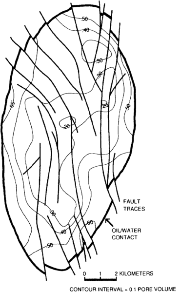
Porosity-weighted average water saturation map for Layer 2 of a Middle Eastern carbonate reservoir.
File history
Click on a date/time to view the file as it appeared at that time.
| Date/Time | Thumbnail | Dimensions | User | Comment | |
|---|---|---|---|---|---|
| current | 20:42, 14 January 2014 | | 889 × 1,444 (71 KB) | Importer (talk | contribs) | Porosity-weighted average water saturation map for Layer 2 of a Middle Eastern carbonate reservoir. Category:Geological methods |
You cannot overwrite this file.
File usage
The following page uses this file: