Hydrodynamics: change in configuration
| Exploring for Oil and Gas Traps | |

| |
| Series | Treatise in Petroleum Geology |
|---|---|
| Part | Predicting the occurrence of oil and gas traps |
| Chapter | Predicting preservation and destruction of accumulations |
| Author | Alton A. Brown |
| Link | Web page |
| Store | AAPG Store |
Fluid contacts can tilt in response to fluid potential gradients in underlying water. If the tilt of the fluid contact exceeds the dip of the reservoir-seal interface on the down-potential (flow downdip) side of the trap, the accumulation will spill downdip. If petroleum is trapped under hydrodynamic conditions on an unclosed structure, decrease in the potential gradient may result in spillage of the petroleum updip.
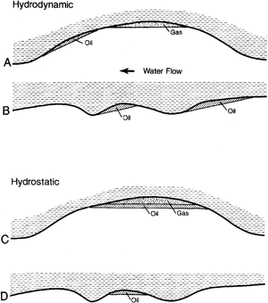
Figure 1 shows the effects of hydrodynamics on trapping. During water movement (Hydrodynamic, top figure), oil accumulations are displaced from the structural crest; gas may remain near the crest of the structure (A). Even unclosed structures can be traps, as long as the downdip tilt is steeper than the tilt to the oil-water contact (B).
If water movement stops (Hydrostatic, lower figure), the accumulations quickly return to trapping at the crest of structural closures (C). Some structural closures may have accumulations; nearby closures may not (D).
Duration of hydrodynamic regimes
Petroleum distribution adjusts to trapping hydrodynamics much faster than changes in natural hydrodynamic regimes.[1] In general, hydrodynamic regimes, especially those established by elevation–head differences in recharge, are time-transient events that are much shorter than the theoretical lifetime of accumulations under hydrostatic conditions. If present hydrodynamic flow affects fluid contacts of reservoirs charged in the past, then spillage and tertiary migration probably have occurred.
Hydrodynamic mapping
To evaluate the potential for spillage from hydrodynamic effects, we can construct maps (potentiometric and hydrodynamic) for the reservoir horizons of interest. Hydrodynamic mapping determines present oil and gas potential minima (traps) (described by Hubbert[1] and Dahlberg[2]). Where data quality is good, hydrodynamic mapping can identify (1) structural closures that have spilled as a result of hydrodynamics and (2) hydrodynamic traps.
Evaluating ancient spillage
Ancient hydrodynamic events that have occurred since charging can be identified by evaluating topographic evolution in the area around the basin of interest (evaluate patterns of subsurface salt dissolution, tectonic history, and map unconformities around the basin). Direction and magnitude of flow can be inferred but not quantified. Although petroleum resumes its hydrostatic configuration once hydrodynamic conditions cease, some traps may have essentially all movable petroleum flushed from their structural fetch area if potentiometric gradients were steep (as shown in Figure 1 A and B).
See also
- Hydrodynamics
- Hydrodynamic traps: mapping
- Trap spillage
- Changes in trapping geometry
- Postaccumulation cementation
- Consequences of spillage
- Hydrodynamic influence on trapping
References
- ↑ 1.0 1.1 Hubbert, M. K., 1953, Entrapment of petroleum under hydrodynamic conditions: AAPG Bulletin, vol. 37, p. 1954–2026.
- ↑ Dahlberg, E. C., 1982, Applied Hydrodynamics in Petroleum Exploration: New York, Springer-Verlag, 161 p.
