Procedure for geometrical analysis
| It has been suggested that this article be merged with [[::Geometrical analysis|Geometrical analysis]]. (Discuss) |
| Exploring for Oil and Gas Traps | |

| |
| Series | Treatise in Petroleum Geology |
|---|---|
| Part | Predicting the occurrence of oil and gas traps |
| Chapter | Exploring for stratigraphic traps |
| Author | John C. Dolson, Mike S. Bahorich, Rick C. Tobin, Edward A. Beaumont, Louis J. Terlikoski, Michael L. Hendricks |
| Link | Web page |
| Store | AAPG Store |
Geometrical analysis is simply dividing a basin's sedimentary section into three-dimensional bodies of strata using regionally correlative surfaces or features as boundaries. The sequence stratigraphic approach uses unconformities or other genetically significant features to divide the section into depositional sequences, systems tracts, and/or parasequences. Recognizing these correlation features is key to identifying depositional sequences properly.
Procedure
The table below lists steps for a geometrical analysis of the sedimentary section of a basin in seismic sections, outcrop sections, and well log sections.
- Identify unconformities (third-order sequence boundaries) in seismic sections, outcrop sections, and regional well log sections.
- Identify other correlation features, such as maximum flooding surfaces, condensed sections, transgressive surfaces.
- Divide the sedimentary section into depositional sequences, systems tracts, and parasequences using the following:
- Seismic sequence analysis
- Well data sequence analysis
- Map the thicknesses of third-order depositional sequences, systems tracts, and important parasequences.
Identifying unconformities
Unconformities are third-order sequence boundaries. They are generally regional onlap surfaces. In basinal settings, they are characterized by onlap of allochthonous deposits (i.e., debris flows, slump deposits, turbidites), prograding deltas, carbonate platform deposits, or evaporites. In shallow-water or nonmarine settings, they are characterized by onlap of strata deposited in fluvial, deltaic, or nearshore marine or peritidal environments.[1] We can identify unconformities using stratigraphic evidence and individual well evidence.
Stratigraphic evidence
- Reflection terminations in seismic sections (onlap, downlap, toplap, or truncation)
- Bed truncation observed in detailed well log cross sections
- Missing biostratigraphic horizons
- Missing facies in a sequence, i.e., abrupt change from fluvial sandstone to marine shale
- Evidence of widespread channeling of platforms or shelves
- Abrupt vertical geochemical changes such as stable isotopes
Individual well evidence
- Dipmeter changes
- Gamma-ray log changes in response to increased uranium concentration at exposure surfaces
- Vertical breaks in thermal maturity profiles (i.e., abrupt vertical change in vitrinite reflection values)
- Changes in lithology as seen in cores that indicate subaerial exposure or nondeposition, as evidenced by the following:
- Paleosols and weathered horizons
- Hematitic grain coatings or dissolution textures unrelated to burial diagenesis
- Clam-bored hardgrounds such as Toredo borings
- Thin lag deposits of bone, phosphate, or shell hash
- Fluid inclusion evidence for atmospheric gases (e.g., argon, helium)
Example of unconformity analysis

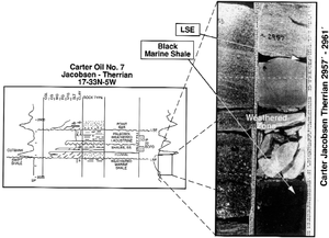
Cores and samples should be examined for evidence of unconformities. These unconformity surfaces should then be calibrated to logs. Logs can then be used to correlate the surfaces to seismic and to other wells. Figure 1[3] shows an example of calibrating unconformity evidence from cores to logs. The Lower Cretaceous Cutbank Sandstone unconformably overlies the Jurassic Swift Formation. A major lowstand surface of erosion (LSE) is shown at depth::2957 ft (901 m) and was identified using the following criteria:
- Missing biostratigraphic horizons
- Subaerial (weathered) zone beneath a channel
- Facies omission (abrupt change from marine shale to a fluvial sandstone)
See also
- Geometrical analysis
- Other correlation features
- Seismic sequence analysis
- Well log sequence analysis
- Combining well log with seismic sequence analysis
References
- ↑ Weber, L. J., J. F. Sarg, and F. M. Wright, 1995, Sequence stratigraphy and reservoir delineation of the middle Pennsylvanian (Desmoinesian), Paradox basin and Aneth field, southwestern U.S.A., in J. F. Read, L. J. Weber, J. F. Sarg, and F. M. Wright, eds., Milankovitch Sea-Level Changes, Cycles, and Reservoirs on Carbonate Platforms in Greenhouse and Ice-House Worlds: SEPM Short Course No. 35, 79 p.
- ↑ Dolson, J. C., and J. T. Piombino, 1994, Giant proximal foreland basin non-marine wedge trap: Lower Cretaceous Cutbank Sandstone, Montana, in J. C. Dolson, M. L. Hendricks, and W. A. Wescott, eds., Unconformity-Related Hydrocarbons in Sedimentary Sequences: Rocky Mountain Assoc. of Geologists, p. 135–148.
- ↑ Dolson, J. C., and D. S. Muller, 1994, Stratigraphic evolution of the Lower Cretaceous Dakota Group, Western Interior, USA., in M. V. Caputo, J. A. Peterson, and K. J. Franczyk, eds., Mesozoic Systems of the Rocky Mountain Region, USA: SEPM Rocky Mountain Section, p. 441–456.