Relating traps to paleogeography
| Exploring for Oil and Gas Traps | |

| |
| Series | Treatise in Petroleum Geology |
|---|---|
| Part | Critical elements of the petroleum system |
| Chapter | Sedimentary basin analysis |
| Author | John M. Armentrout |
| Link | Web page |
| Store | AAPG Store |
A paleogeography map of a reservoir interval, reservoir thickness, and fields (producing from the same reservoir interval) shows relationships between production and geology that may be used to locate prospects in untested areas.
Procedure
The list below suggests a procedure for relating fields to paleogeography and reservoir thickness.
- Plot paleogeography, reservoir thickness, and field location on the same map.
- Relate paleogeographic features (axis of canyons, shelf/slope break, shorelines, etc.), reservoir thickness, and field locations to trap development.
Example

Figure 1 Relationship between 23 fields in the High Island-East Breaks depocenter that produce from the Glob alt sandstones and the Glob alt sandstone 200-ft (60-m) isopach.
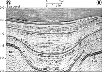
Figure 2 Depositional strike seismic reflection profile across one of these valleys.
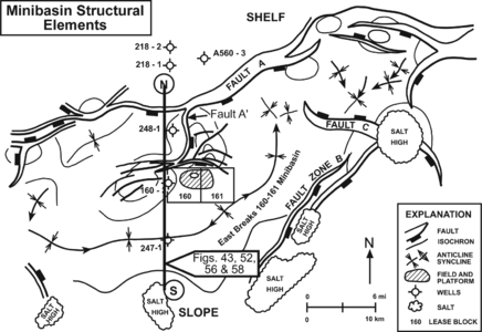
Figure 3 Structural elements that define the East Breaks 160-161 minibasin, which is bound on the north by fault A, on the east by faults B and C, and on the south by a salt-cored high. Copyright: Armentrout et al.;[1] courtesy Springer-Verlag.
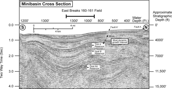
Figure 4 North–south seismic section through the East Breaks 160-161 intraslope minibasin, showing the location of the East Breaks 160-161 field.

Figure 5 North–south seismic section showing the hypothetical model for migration pathways within the East Breaks 160-161 field. Copyright: Dow et al.;[2] courtesy Gulf Coast SEPM.


Figure 1 shows the relationship between 23 fields in the High Island-East Breaks depocenter that produce from the Glob alt sandstones and the Glob alt sandstone 200-ft (60-m) isopach. Most of the fields with Glob alt reservoirs occur around the perimeter of the maximum thickness of net sandstone, near the 200-ft (60-m) isopach. Nearly all of the Glob alt reservoirs occur basinward of the lowstand middle-to-outer neritic biofacies boundary [approximately length::600 ft (200 m) water depth]. Thus, they are downslope from the shelf/slope inflection and below normal wave base where sedimentation is dominated by gravity-flow processes.
Deposition by gravity-flow processes occurs within physiographic lows.[3][4] Although each field occurs within a local structural high, most have a major stratigraphic component related to their transport through slope channels and deposition as a gravity-flow deposit within the axis of a salt-withdrawal valley (see Figures 3, 4, and 5 for the East Breaks 160-161 field). The sands within these valleys were deposited with a slope-parallel orientation. The trapping structure develops after reservoir deposition as the dip-oriented sand bodies are tilted along the flanks of the salt-cored anticlines (Figure 2). The anticlines continue to grow, and the tilt of the sand body becomes progressively more accentuated as each successive cycle of synclinal fill accumulates and displaces the underlying salt.
This process accelerates during relative lowstand of sea level when the river systems discharge their loads near to or into the heads of the slope valleys.[5][6]
Explanation of example
In Figure 1, producing fields are along the 200-ft (60-m) net sand contour or beyond rather than in the axial thick. This is because of gravity-flow sands accumulating within the synclinal valley axes, which continue to subside through time.
The Figure 2 shows a depositional strike seismic reflection profile across one of these valleys. The high-amplitude, more continuous reflections correlate with condensed-section claystones and often bracket pressure compartments due to their very low permeability. Between the condensed sections are the sand-prone early lowstand systems tract, sometimes with hummocky-mounded facies suggesting channel complexes, overlain by silt-prone late lowstand deposits. The differential loading of salt by sediment accumulation along the synclinal valley axis results in differential rotation of each depositional sequence. This rotation along the synclinal flanks results in the early lowstand gravity-flow sands pinching-out structurally upward, providing potential hydrocarbon traps along the valley margins.[7][8][9][10]
The isochron thick of the Glob alt sands in the figure represents the sand-prone slope/valley fill of the Glob alt sequence. Understanding the interplay of depositional processes and tectonic deformation is essential to hydrocarbon exploration in GOM minibasins.
Basin slope exploration plays
Gravity-flow events, such as slumps and slides, can initiate transport of sediment downslope. Transport by debris flows and turbidites moving downslope may be confined to narrow valleys or spread outward into the less-confining minibasin of the Gulf of Mexico slope.[3][4] These sedimentary systems consist of channel elements through which sediment is transported to lobe-and-sheet depositional elements within the minibasins[11] Confined flow elements are typically channels with levees resulting from sediment fallout from overbanking turbulent flow. The channel-levee complexes are elongate but may stack into thick successions of potential reservoir facies.[7] The less-confined lobe-and-sheet facies may spread out within the minibasins, forming large-volume reservoir packages.[8] Winn and Armentrout[12] have compiled examples of this spectrum of gravity-flow exploration targets, which are critical elements of minibasin petroleum systems.
See also
References
- ↑ Armentrout, J. M., S. J. Malacek, P. Braithwaite, and C. R. Beeman, 1991, Seismic facies of slope basin turbidite reservoirs, East Breaks 160-161 field: Pliocene–Pleistocene, northwestern Gulf of Mexico, in P. Weimer and M. J. Link, eds., Seismic Facies and Sedimentary Processes of Submarine Fans and Turbidite Systems: New York, Springer-Verlag, p. 223–239.
- ↑ Dow, W. G., M. A. Yukler, J. T. Senftle, M. C. Kennicutt II, and J. M. Armentrout, 1990, Miocene oil source beds in the East Breaks basin, Flex-Trend, offshore Texas: Proceedings, Gulf Coast Section SEPM 9th Annual Research Conference, p. 139–150.
- ↑ 3.0 3.1 Kneller, B., 1995, Beyond the turbidite paradigm: physical models for deposition of turbidites and their implications for reservoir prediction, in Hartley, A. J., Prosser, D. J., eds., Characterization of Deep Marine Clastic Systems: Geological Society, London, Special Publication 94, p. 31–49.
- ↑ 4.0 4.1 Kneller, B., and B. McCaffrey, 1995, Modelling the effects of salt-induced topography on deposition from turbidity currents, in C. J. Travis, H. Harrison, M. R. Hudec, B. C. Vendeville, F. J. Peel, and B. F. Perkins, eds., Salt, Sediment and Hydrocarbons: Gulf Coast Section SEPM Sixteenth Annual Research Conference, p. 137–145.
- ↑ Anderson, R., N., Abdulah, K., Sarzalejo, S., Siringan, F., Thomas, M., A., 1996, Late Quaternary sedimentation and high-resolution sequence stratigraphy of the East Texas shelf, in DeBatist, M., Jacobs, P., eds., Geology of Siliciclastic Shelf Seas: Geological Society of London Special Publication 117, p. 94–124.
- ↑ Winker, C., D., 1996, High-resolution seismic stratigraphy of a late Pleistocene submarine fan ponded by salt-withdrawal minibasins on the Gulf of Mexico contentental slope: Proceedings, Offshore Technology conference, no. 38, vol. 1, p. 619–628.
- ↑ 7.0 7.1 Armentrout, J. M., 1996, High-resolution sequence biostratigraphy: examples from the Gulf of Mexico Plio–Pleistocene, in Howell, J., Aiken, J., eds., High Resolution Sequence stratigraphy: Innovations and Applications: The Geological Society of London Special Publication 104, p. 65–86.
- ↑ 8.0 8.1 Bilinski, P. W., McGee, D. T., Pfeiffer, D. S., Shew, R. S., 1995, Reservoir characterization of the “S” sand, Auger field, Garden Banks 426, 427, 470, and 471, in Winn, R. D. Jr., Armentrout, J. M., eds., Turbidites and Associated Deep-water Facies: SEPM (Society for Sedimentary Geology) Core Workshop No. 20, p. 75–93.
- ↑ McGee, D. T., Bilinski, P. W., Gary, P. S., Pfeiffer, D. S., Sheiman, J. L., 1994, Geologic models and reservoir geometries of Auger field, deepwater Gulf of Mexico: Proceedings, Gulf Coast Section SEPM 15th Annual Research conference, p. 245–256.
- ↑ Weimer, P., A. H. Bouma, and B. F. Perkins, eds., 1994, Submarine Fans and Turbidite Systems: Sequence Stratigraphy, Reservoir Architecture and Production Characteristics, Gulf of Mexico and International: Gulf Coast Section SEPM Foundation Fif- teenth Annual Resesarch Conference Proceedings, 440 p.
- ↑ Armentrout, J., M., 1991, Paleontological constraints on depositional modeling: examples of integration of biostratigraphy and seismic stratigraphy, Pliocene–Pleistocene, Gulf of Mexico, in Weimer, P., Link, M., H., eds., Seismic Facies and Sedimentary Processes of Submarine Fans and Turbidite Systems: New York, Springer-Verlag, p. 137–170.
- ↑ Winn, R. D., and J. M. Armentrout, eds., 1995, Turbidites and Associated Deep-water Facies: SEPM Core Workshop 20, 176 p.
External links
| find literature about Relating traps to paleogeography |