Bakken and Three Forks Formations, Williston Basin, North Dakota and Montana (USGS)
By Kristen Marra, U.S. Geological Survey, Denver, Colorado, USA
Commentary[edit]
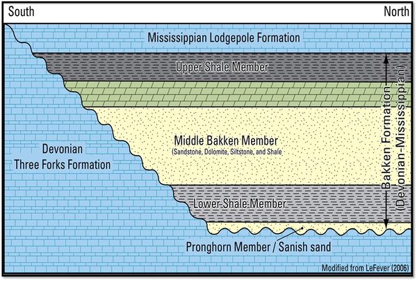
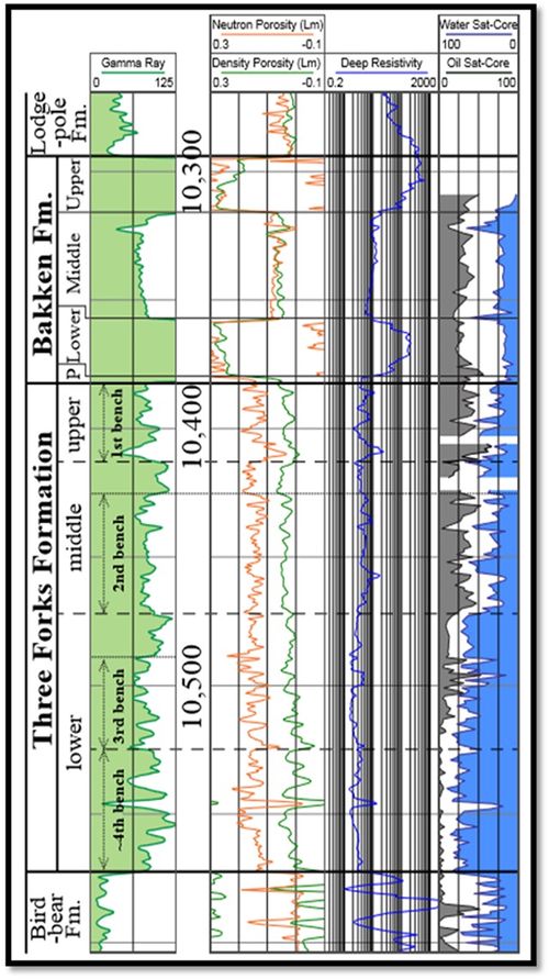
The Bakken Petroleum System of the Williston Basin (North Dakota and Montana) includes the Bakken Formation, the underlying Three Forks Formation, and the overlying Lodgepole Formation (lower part). The Bakken Formation comprises four distinct units: the Pronghorn Member (formerly defined as the “Sanish sand”) and three informal members: 1) lower shale member, 2) middle Bakken member, and 3) upper shale member. The source rocks of the system are the organic-rich upper and lower shales of the Bakken, which average approximately 11% total organic carbon and consist of type-II kerogen. The primary reservoir targets are low-porosity and low-permeability members of the middle Bakken and Three Forks (upper part), with continued exploration into the middle and lower intervals of the Three Forks and the intervening Pronghorn Member. Bakken oil is also found in limestones of the Lodgepole Formation ([1]; [2]).
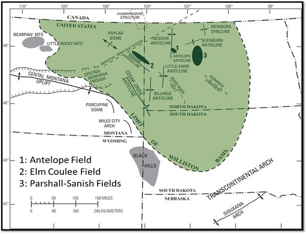
Production in the Bakken and Three Forks Formations began in the early 1950s at Antelope Field. Drilling later shifted to the Billings Nose area (North Dakota), where the upper Bakken shale member was exploited. The first horizontal Bakken well was drilled in this region in 1987. Major sweet spot discoveries include Elm Coulee Field in 2000 and Parshall Field in 2005–2006. Since that time, exploration and production has expanded across the basin, resulting in more than 11,000 productive wells in the Bakken to date. Successful horizontal tests of the underlying Three Forks Formation were completed in Divide County (North Dakota) in 2005–2006. Drilling into the Three Forks Formation has expanded north and south along the main structure of the Nesson anticline, along with expansion into the central Williston Basin (North Dakota) and eastward into the region of Parshall Field. More than 5000 Three Forks wells were in existence by mid-2020. Although the upper Three Forks interval is the primary target due to proximity to the organic-rich lower Bakken shale member, drilling and exploration of the middle and lower Three Forks continues across the basin ([3]; [1]; [4]; [5]).
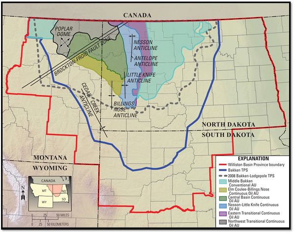
The Bakken and Three Forks Formations were assessed by the U.S. Geological Survey (USGS) in 2013, resulting in undiscovered, technically recoverable resource estimates of 3.65 billion barrels of oil (BBO) for the Bakken and 3.73 BBO for the Three Forks Formation (total mean resource estimate of 7.38 BBO; [1]). The USGS is currently conducting a revised resource assessment of the Bakken and Three Forks Formations.
Additional recent assessments of the Bakken and Three Forks Formations include:
- Texas Bureau of Economic Geology[6]: 262 BBO generated (oil in place) in the Bakken, Three Forks, Pronghorn, and Scallion units
- Platte River Associates[7]: 3.4–4.0 BBO technically recoverable in the Bakken and Three Forks Formations (North Dakota region only)
- Saputra et al.[8]: 8 BBO technically recoverable (plus addition of 5 BBO from existing wells) in the Bakken and Three Forks Formations
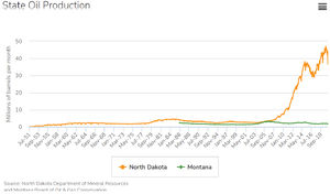
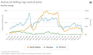
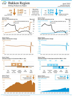
Since 2010, production in the Bakken has generally increased Figure 1, with notable declines beginning in 2014 (Figure 2) due to a drop in oil prices and in mid-2020 due to the decrease in demand during in the ongoing COVID-19 pandemic. Overall, oil production has remained high, and North Dakota continues to be the second largest oil producing state in the country (https://www.minneapolisfed.org/region-and-community/bakken).
Play Summary[edit]
| Country | USA |
| State/Privince | North Dakota and Montana |
| Basin Name | Williston (U.S. side only) |
| Basin Type | Intracratonic sedimentary basin |
| Formation | Bakken |
| Geologic Age | Devonian–Mississippian |
| Reservoir Type | Shale, silt, dolostone, sandstone, limestone |
| Hydrocarbon Type | Oil (main product) |
| GOR (scf/bbl) | 200–2000 |
| Water Yield (bbl/bbl oil) | Variable due to sweetspots |
| Discovery Year | 1953 |
| Discovery Well | Stanolind Oil and Gas Co. #1 Woodrow Starr (Antelope anticline) |
| First Production Year | 1953 |
| Current Oil Production (bo/d) | Figure 3 |
| Peak Oil Production (bo/d, Yr) | Figure 3 |
| Current Gas Production (mmcf/d) | Figure 3 |
| Peak Gas Production (mmcf/d, Yr) | Figure 3 |
| Current Condensate Production (bo/d) | |
| Peak Condensate Production (bo/d, Yr) | |
| Cumulative Oil Production (MMB) | 2622 (August 2020) |
| Cumulative Gas Production (TCF) | 3.8 (August 2020) |
| Productive Acres (ac) | >13,500,000 |
| Horizontal Well Spacing (ac) | 320–640_1280 (Variable) |
| Total Wells (Yr) | >11,000 (mid-2020) |
| Total Horizontal Wells (Yr) | >11,000 (mid-2020) |
| Mean Well 30-day IP (BOE/d) | Variable due to sweetspots |
| Mean Well EUR (BOE) | 200,000–500,000 (Variable due to sweetspots) |
Geology[edit]
| Lithology | Shale, silt, dolostone, limestone, sandstone |
| Depth (ft) | 6500–10,500 |
| Thickness (ft) | 0–140 (including Middle Bakken and Upper and Lower Bakken shales) |
| Porosity (%) | Variable, Sandstones: 5–9%; Dolomite: up to 15% |
| Permeability (md) | Variable, Sandstones: 0.1; Dolomite: 0.01 |
| Water Saturation (%) | 30–100 |
| Reservoir Pressure (psi) | Variable, 0.5 to 0.78 psi/ft across basin |
| TOC (wt%) | Avg 11% for Upper and Lower Bakken shales |
| Measured VR (%Ro) | (Suppressed) |
| Tmax (°C) | 425–450 |
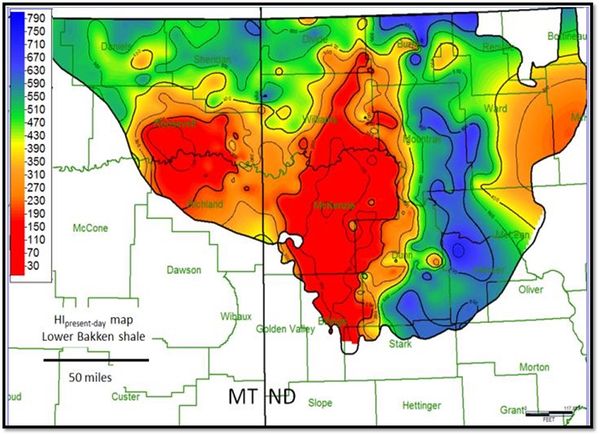
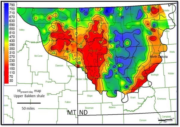
| Hydrogen Index (mg HC/g) | <100 to >650 |
| S2 (mg HC/g) | |
| Kerogen Type | Type II |
| XRD Quartz (wt%) | Variable |
| XRD Carbonate (wt%) | Variable |
| XRD Clay (wt%) | Variable |
| Static Young's Modulus (106 psi) | |
| Static Poisson's Ratio |
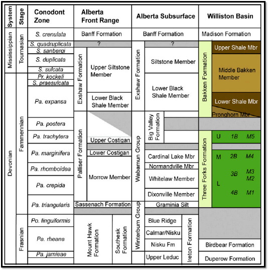
Stratigraphic Column[edit]
Garcia-Fresca et al.[9]
Maps[edit]
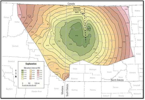
General Structure Map (Pollastro et al.[10]).
General Basin Map (Pollastro et al.[10]).
General Stratigraphy (Pollastro et al.[10], modified from LeFever[11]).
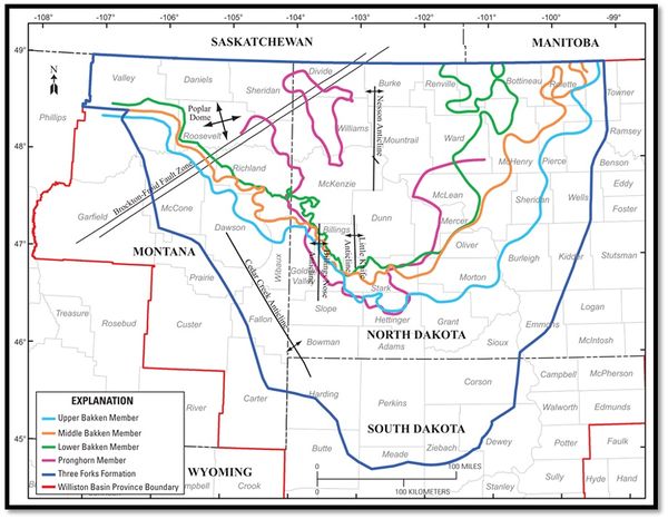
Bakken Formation Extents (Gaswirth and Marra[1]).
Lower Bakken Shale HI Map (Jin and Sonnenberg[12]).
Upper Bakken Shale HI Map (Jin and Sonnenberg[12]).
2013 USGS Bakken Assessment Unit Boundaries (Gaswirth et al.[13]).
Type Log[edit]
General type log example, Enerplus Resources USA Corp - Hognose 152-94-18B-19H-TF (Neisheim[14]).
References[edit]
- ↑ 1.0 1.1 1.2 1.3 Gaswirth, S. B. and K. R. Marra, 2015, U.S. Geological Survey 2013 assessment of undiscovered resources in the Bakken and Three Forks Formations of the U.S. Williston Basin Province: AAPG Bulletin, v. 99, no. 4, p. 639–660.
- ↑ Sonnenberg, S. A., 2017, Sequence Stratigraphy of the Bakken and Three Forks Formations, Williston Basin, USA, in Bruce Hart, Norman C. Rosen, Dorene West, Anthony D’Agostino, Carlo Messina, Michael Hoffman, Richard Wild, eds., Sequence Stratigraphy: The Future Defined: SEPM Gulf Coast Section Publications, v. 36, DOI: https://doi.org/10.5724/gcs.17.
- ↑ Sonnenberg, S. A. and A. Pramudito, 2009, Petroleum geology of the giant Elm Coulee field, Williston Basin: AAPG Bulletin, v. 93, no. 9, p. 1127–1153.
- ↑ Nesheim, T. O., 2019, Examination of downward hydrocarbon charge within the Bakken-Three Forks petroleum system–Williston Basin, North America: Marine and Petroleum Geology, v. 104, p. 346-360.
- ↑ IHS Markit®, 2020, Enerdeq™ U.S. well history and production database: Englewood, Colo., IHS Markit, accessed August 2020, http://www.ihsenergy.com.
- ↑ Gherabati, S. A., H. S. Hamlin, K. M. Smye, R. L. Eastwood, F. R. Male, and G. McDaid, 2019, Evaluating hydrocarbon-in-place and recovery factor in a hybrid petroleum system: Case of the Bakken and Three Forks in North Dakota: Interpretation, v. 7, no. 3, https://doi.org/10.1190/INT-2018-0213.1
- ↑ Theloy, C., J. E. Leonard, C. O. Leonard, and P. W. Ganster, 2017, Using an uncertainty assessment approach for estimating recoverable reserves from the Bakken Petroleum System in North Dakota: Search and Discovery Article #10918, posted March 6, 2017.
- ↑ Saputra, W., W. Kirati, and T. Patzek, 2019, Generalized extreme value statistics, physical scaling and forecasts of oil production in the Bakken Shale: Energies, v. 12, no. 19, https://doi.org/10.3390/en12193641.
- ↑ Garcia-Fresca, B., D. Pinkston, R. G. Loucks, and R. LeFever, The Three Forks playa lake depositional model: Implications for characterization and development of an unconventional carbonate play: AAPG Bulletin, v. 102, no. 8, p. 1455-1488.
- ↑ 10.0 10.1 10.2 Pollastro, R. M., L. N. R. Roberts, and T.A. Cook, 2012, Geologic model for the assessment of technically recoverable oil in the Devonian-Mississippian Bakken Formation, Williston Basin, in J.A. Breyer ed., Shale reservoirs-Giant resources for the 21st century: AAPG Memoir 97, p. 205-257.
- ↑ LeFever, J., and L. Helms, 2006, Bakken Formation Reserve Estimates: accessed June 2, 2021, https://www.researchgate.net/publication/237638511_Bakken_Formation_Reserve_Estimates.
- ↑ 12.0 12.1 Jin, H., and S. A. Sonnenberg, 2013, Characterization for source rock potential of the Bakken Shales in the Williston Basin, North Dakota and Montana: URTeC 2013, Denver, Colorado, 12-14 August, accessed June 2, 2021, https://archives.datapages.com/data/urtec/usa/2013/urtec-1581243-jin.pdf.
- ↑ Gaswirth, S. B., K. R. Marra, T. A. Cook, R. R. Charpentier, D. L. Gautier, D. K. Higley, T. R. Klett, M. D. Lewan, P. G. Lillis, C. J. Schenk, M. E. Tennyson, and K. J. Whidden, 2013, Assessment of undiscovered oil resources in the Bakken and Three Forks Formations, Williston Basin Province, Montana, North Dakota, and South Dakota, 2013: U.S. Geological Survey Fact Sheet 2013-3013, 4 p.
- ↑ Nesheim, T. O., 2019, Examination of downward hydrocarbon charge within the Bakken-Three Forks petroleum system – Williston Basin, North America: Marine and Petroleum Geology, v. 104, p. 346-360.
