Depocenter
| Exploring for Oil and Gas Traps | |

| |
| Series | Treatise in Petroleum Geology |
|---|---|
| Part | Critical elements of the petroleum system |
| Chapter | Sedimentary basin analysis |
| Author | John M. Armentrout |
| Link | Web page |
| Store | AAPG Store |
Depocenter refers to an area or site of maximum deposition, or the geographic location of the thickest part of any specific geographic unit in a depositional basin.[1]
Within a basin, different areas receive different amounts of sediment through time, resulting in numerous depocenters. Each depocenter is an area containing a thick stratigraphic succession. These different depocenters have unique histories of sediment accumulation, compaction, subsidence, deformation, and thermal maturation of potential hydrocarbon source rocks. Delineation of these depocenters is the second step in basin analysis. Subdividing a depocenter into age-significant units and depositional cycles is the topic of section C.
Sediment supply rate and facies patterns
Within each depocenter, facies do one of the following:[2]
- Prograde if the rate of sediment supply exceeds the rate of accommodation space formation.
- Aggrade if the rate of sediment supply equals the rate of accommodation space formation.
- Retrograde if the rate of sediment supply is less than the rate of accommodation space created.
Siliciclastic vs. carbonate supply

Most siliciclastic basins have sediment supplied from drainage areas outside of the boundary of the depositional basin. Lateral changes in sediment input locations can result in lateral shifts in the depocenter if enough space exists to accommodate the sediment near each input location. In carbonate basins, organisms near the site of accumulation produce most sediment, and facies tend to extend over large platform areas.
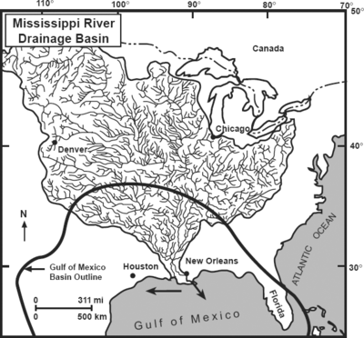
Figure 1 is a map of the drainage basin of the modern Mississippi River, illustrating the network of rivers feeding into one sediment input point. The Holocene depocenter of the Mississippi River is immediately offshore and west of the river mouth. Smaller drainage basins also supply terrigenous sediment to the western and central Gulf of Mexico, while in situ carbonate factories supply most of the sediment to the Florida peninsula.
Depocenter complexes
In basins with relatively rapid subsidence and multiple sediment supply systems, a complex set of depocenters occurs. Each depocenter has a unique history of accumulation, based on
- variations in source rock maturation,
- manner and timing of hydrocarbons expulsion and migration, and
- style of fluid entrapment and preservation.
Recognizing the temporal and spatial distribution of each depocenter is critical to understanding basin history and petroleum system formation. Along the basin margin, depocenters may be dominated by deltaic complexes. On the slope and basin floor, depocenters are related to transport systems of gravity-flow processes.
Mapping age of thicks
Mapping age-specific isopach thicks defines laterally shifting sites of maximum deposition along the margin of a basin. Each depocenter has a unique history of accumulation with consequent variations in maturation, migration, and entrapment history of associated petroleum systems.
Mapping depocenters
Follow the procedure detailed below to map depocenters. Note: Isopach maps (step 1) are shown in this section. Steps 2-5 are detailed in sections C and D.
- Make isopach maps of individual depocenters using well data and high-quality seismic profiles calibrated to well data.
- Establish correlation of surfaces bounding each tectonostratigraphic phase and construct isopach maps or relative thickness maps.
- Map deltaic/shelf depocenters by mapping net sand distribution from well data.
- Identify shelf margins using biostratigraphic and seismic facies analysis.
- Identify deepwater intraslope basins from isochron mapping and calibration to stratigraphy in wells.
See also
References
- ↑ Gary, M., R. McAfee, Jr., and C. L. Wolf, 1974, Glossary of Geology: AGI, 805 p.
- ↑ Van Wagoner, J., C., H. W. Posamentier, R. M. Mitchum, P. R. Vail, J. F. Sarg, T. S. Loutit, and J. Hardenbol, 1988, An overview of the fundamentals of sequence stratigraphy and key definitions: an integrated approach: SEPM Special Publication 42, p. 39–45.
- ↑ Coleman, J. M., and H. H. Roberts, 1991, Mississippi River depositional system: model for the Gulf Coast Tertiary, in D. Goldthwaite, ed., An Introduction to Central Gulf Coast Geology: New Orleans Geological Society, p. 99-121