Other correlation features
| Exploring for Oil and Gas Traps | |

| |
| Series | Treatise in Petroleum Geology |
|---|---|
| Part | Predicting the occurrence of oil and gas traps |
| Chapter | Exploring for stratigraphic traps |
| Author | John C. Dolson, Mike S. Bahorich, Rick C. Tobin, Edward A. Beaumont, Louis J. Terlikoski, Michael L. Hendricks |
| Link | Web page |
| Store | AAPG Store |
Besides unconformities, other surfaces and stratigraphic features are useful for correlation. Unconformities serve as boundaries for first-, second-, and third-order sequences. Other correlation features—maximum flooding surfaces, condensed sections, transgressive surfaces, and downlap surfaces—subdivide the third-order sequences into systems tracts and parasequences.
Maximum flooding surface[edit]
A maximum flooding surface separates “younger from older strata across which there is an abrupt increase in water depth. This deepening is commonly accompanied by minor submarine erosion or nondeposition, but not by subaerial erosion due to stream rejuvenation or basinward shift in facies”.[1] Submarine erosion ranges from inches to tens of feet, with several feet being common.
A maximum flooding surface represents the point of maximum shoreline transgression. It marks the “turnaround” of the sequence from transgressive to regressive events. The maximum flooding surface is the physical boundary between the transgressive system tract (TST) and the highstand systems tract (HST). In basinward positions, it is contained within the condensed section. In starved areas, it is associated with a hardground or marine dissolution surface.[2] Galloway[3] argues that maximum flooding surfaces are more easily recognized and mapped than unconformities and are an alternative method of subdividing sequences.
Condensed section[edit]
A condensed section is “a facies consisting of thin hemipelagic or pelagic sediments deposited as the parasequences step landward and as the shelf is starved of terrigenous sediment”.[1] They are most extensive during times of regional shoreline transgressions. Condensed sections contain the greatest abundance and diversity of fauna within a third-order sequence. The section is thin because it accumulates at very slow rates.
Transgressive surface[edit]
A transgressive surface forms during a transgression. It is the physical boundary between the lowstand and transgressive systems tracts and is defined by the change from forestepping to backstepping. It merges with the basal unconformity landward of the point where the lowstand systems tract pinches out.[2]
Downlap surface[edit]
A downlap surface (DLS) is a marine flooding surface onto which the toes of prograding clinoforms of the overlying highstand systems tract downlap. The surface represents a change from a retrogradational depositional pattern to an aggradational pattern. It is the surface of maximum flooding, recognized by downlap of overlying units and apparent truncation of underlying units. A downlap surface is common at the base of prograding deltas and the top of submarine fans.
Example: identifying MFS with biostratigraphic data[edit]
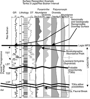
In Figure 1 from the Gulf of Suez basin, planktonic and foraminiferal data taken on a 30-ft (9.1-m) interval show abundance peaks crossing a sharp log break from a thin carbonate to marine shale. Abundance peaks such as this are a common feature of the maximum flooding surface (MFS). Seismic and well log correlations confirm that this break is an MFS overlain by a prograding clastic wedge.
The computer-generated labels on the right side post alternative sequence boundary picks. In this way the interpreter can choose the best pick from all available well and seismic information.
See also[edit]
- Geometrical analysis
- Procedure for geometrical analysis
- Seismic sequence analysis
- Well log sequence analysis
- Combining well log with seismic sequence analysis
- Sequence stratigraphy
- Biostratigraphy in sequence stratigraphy
References[edit]
- ↑ 1.0 1.1 Van Wagoner, J. C., 1995, Overview of sequence stratigraphic foreland basin deposits: terminology, summary of papers, and glossary of sequence stratigraphy, in J. C. Van Wagoner, and G. T. Bertram, eds., Sequence stratigraphy of Foreland Basin Deposits: Outcrop and Subsurface Examples from the Cretaceous of North America: AAPG Memoir 64, p. ix–xxi.
- ↑ 2.0 2.1 Weber, L. J., J. F. Sarg, and F. M. Wright, 1995, Sequence stratigraphy and reservoir delineation of the middle Pennsylvanian (Desmoinesian), Paradox basin and Aneth field, southwestern U.S.A., in J. F. Read, L. J. Weber, J. F. Sarg, and F. M. Wright, eds., Milankovitch Sea-Level Changes, Cycles, and Reservoirs on Carbonate Platforms in Greenhouse and Ice-House Worlds: SEPM Short Course No. 35, 79 p.
- ↑ Galloway, W. E., 1989, Genetic stratigraphic sequences in basin analysis I: architecture and genesis of flooding-surface bounded depositional units: AAPG Bulletin, vol. 73, p. 125–142.
