File:M91Ch13FG93.JPG
Original file (600 × 704 pixels, file size: 72 KB, MIME type: image/jpeg)
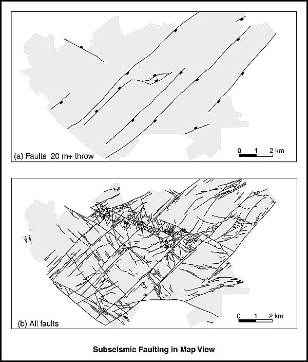
Fault maps of the East Pennine coalfield, United Kingdom. In map (a), only faults with throws of 20 m (64 ft) or more are shown. These are equivalent to faults that are detectable by seismic surveys at reservoir depths. In map (b), every mapped fault is shown, with fault throws of between 10 cm (4 in.) and 180 m (590 ft) (from Watterson et al., 1996). Reprinted with permission from the Journal of Structural Geology. Shepherd, M., 2009, Structural geology: Faults, in M. Shepherd, Oil field production geology: AAPG Memoir 91, p. 107-122.
File history
Click on a date/time to view the file as it appeared at that time.
| Date/Time | Thumbnail | Dimensions | User | Comment | |
|---|---|---|---|---|---|
| current | 21:40, 29 April 2015 | | 600 × 704 (72 KB) | Molyneux (talk | contribs) | Fault maps of the East Pennine coalfield, United Kingdom. In map (a), only faults with throws of 20 m (64 ft) or more are shown. These are equivalent to faults that are detectable by seismic surveys at reservoir depths. In map (b), every mapped fault i... |
You cannot overwrite this file.
File usage
The following page uses this file: