South Pass 62 field
| Horizontal Wells: Focus on the Reservoir | |
| |
| Series | Methods in Exploration No. 14 |
|---|---|
| Chapter | Results and conclusions of a horizontal-drilling program at South Pass 62 salt-dome field |
| Author | E. P. Mason, M. J. Bastian, R. Detomo, M. N. Hashem, A. J. Hildebrandt |
| Link | Web page |
| Store | AAPG Store |
South Pass 62 field, lying 50 km southeast of the Mississippi River delta in 100 m of water (Figure 1), was discovered in 1965. It was developed with 61 directionally drilled wells from three platforms in the late 1960s, redeveloped from 1986 to 1988 with 31 wells from a fourth platform, and redeveloped again from 1994 to 1997 with horizontal and directionally drilled slim-hole sidetracks (Figure 2, Figure 3). A 3-D seismic-based field study completed in 1994 identified reservoir targets for the horizontal-drilling program. Cumulative production from block 62 is 108 MMBO and 170 BCFG. Peak daily production rates reached 30,000 bbl and 50 MMCFG in 1970 before declining to 2000 bbl in 1994.
Geologic setting[edit]
SP62 field lies on the south rim of a large, salt-withdrawal minibasin (Cheetah minibasin, Figure 1). The south rim is defined by a large, pressure-changing, north-dipping, counterregional fault. The north flank is defined by a series of arcuate, regional, south-dipping faults.
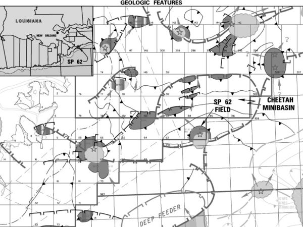
Figure 1 South Pass 62 field is located 50 km southeast of the mouth of the Mississippi River in 100 m of water. Dark gray indicates oil fields. Light gray refers to salt domes or tabular salt.
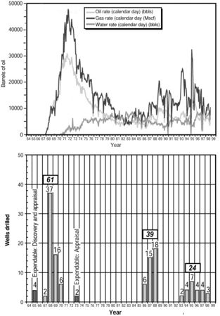
Figure 2 (a) Daily production of oil, gas, and water in the South Pass 62 field, plotted by year. Production decreased from peak rates in 1971 to a low of 2000 BOPD in 1994. (b) Well activity by year in the South Pass 62 field. Dark gray bars indicate exploratory and appraisal wells. Light gray bars indicate development and redevelopment wells. Primary field development occurred between 1967 and 1970, redevelopment in the mid-1980s, and the horizontal-drilling program in the mid-1990s.
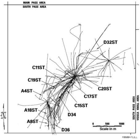
Figure 3 South Pass 62 field base map. Eleven horizontal wells and sidetracks were drilled between 1993 and 1997.


Basin formation began in the early Miocene in response to sediment loading. As the ancestral Mississippi River deposited sediment in the north, mobile salt was forced southward into a salt ridge. This ridge provided a backstop for early Miocene turbidites cascading down the continental slope. Continued deposition resulted in further loading, continued salt-ridge growth, and eventual rupture of the overlying Eocene chalk along the ridge crest. Salt, squeezed out of the ridge, localized into a dome at SP62.
The Cheetah minibasin is extraordinarily rich; almost every closure within the basin contains oil.
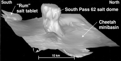
Figure 4 Three-dimensional rendering of South Pass 62 salt dome piercing an early Miocene horizon.
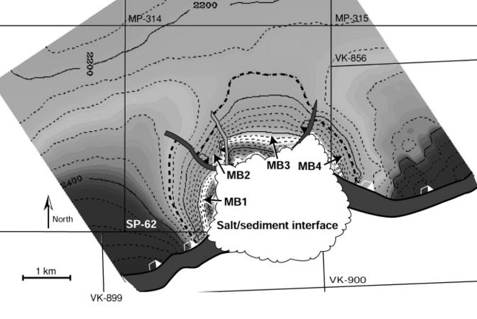
Figure 5 N6N8 sandstone time-structure map in milliseconds showing structural dips in the South Pass 62 field increasing adjacent to the salt. The four megacompartments (MB1, MB2, MB3, and MB4) are defined by large faults.
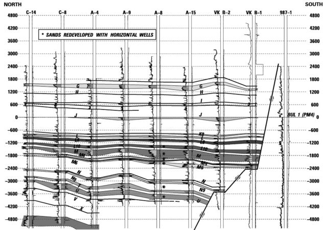
Figure 6 North-south-trending stratigraphic cross section flattened on the Pliocene J sandstone, showing the seven sandstones exploited with horizontal wells in the South Pass 62 field.


Structure[edit]
Salt and salt-related faulting dominate the structure and form the trap at South Pass 62 field. Salt rises from a depth of approximately 8000 m through Eocene chalk and Miocene, Pliocene, and Pleistocene clastics to within 200 m of the seafloor (Figure 4). The salt body leans to the south and is mushroom shaped, with a thin root and massive head. The north face is concave, sculpted by a north-dipping arcuate slump. Numerous thin salt lenses as much as several hundred meters thick are found on the west flank of the dome. These lenses are defined by well penetrations but are unseen on 3-D seismic data.
Formation structure is characterized by dips in excess of 70° adjacent to the salt, and decreasing to less than 10° away from the structure (Figure 5).
Faults are prevalent at SP62. Approximately 200 seismically resolvable faults with throws ranging from five to hundreds of meters dissect and compartmentalize the producing horizons. The field is separated into four megacompartments by three major faults: (1) a large, counterregional fault/salt evacuation surface separating the productive north flank from the nonproductive south flank; (2) an arcuate slump defining the north salt face; and (3) a fault system antithetic to the slump. These faults have always been barriers to flow, despite sandstone-on-sandstone juxtaposition across each respective fault.
The mushroom-shaped salt overhang provides an excellent trap at SP62. Hydrocarbon column heights in excess of 900 m are common.
Stratigraphy and depositional environment[edit]
Approximately 60 Piocene and Miocene deltaic and turbidite pay sandstones range in depth from 1000 to 6000 m. Horizontal wells focused on seven late Miocene deltaic and shore-face sandstones (Figure 6). Typically, these sandstones were fine grained, well sorted, uncemented, and normally pressured.
Upper-shoreface sandstones (e.g., M4) typically were 3 to 6 m thick, continuous, upward coarsening, well connected, and easy to correlate. Horizontal wells in these reservoirs were the program's most productive and profitable (C11 and D32). Excellent connectivity and continuity resulted in high rates and good drainage.
Lower-shoreface intervals were characterized by thin beds, low resistivity, and high continuity (N9 and U-U1). These zones consisted of 30- to 90-m bundles of centimeter- to meter-thick sandstone members. Individual sandstone members were difficult to correlate, but the gross intervals were not. Historically, at SP62, these intervals had produced small volumes at low rates using conventional gravel packs. Laterals drilled through lower-shoreface deposits were disappointing in that they sanded up after producing small amounts of oil. The use of pre-perforated screens might have alleviated this problem.
Distributary channels, typified by the L10, M8, and V series, were characterized by rapid changes in thickness, variable connectivity and water contacts, and inconsistent drainage. Thicknesses ranged from a few meters to more than 30 m. Channel geometries and drainage were difficult to predict, despite integration of all well, production, and seismic data. In nearly every well penetrating channelized reservoirs, sandstone thickness and hydrocarbon distribution were significantly different than predicted. Laterals placed in channelized intervals yielded both extremely profitable and productive wells (C20st, A8st), as well as the most costly failure (D34).
One horizontal well was drilled into the M sandstone, an incised valley deposit. The M sandstone is a massive, high-net/gross-ratio interval characterized by extreme variations in thickness. Thicknesses ocassionally exceed 100 m. On gamma-ray logs, the M is blocky, with a sharp base and top. On seismic data and in cross section, the base cuts through different stratigraphic intervals, characteristic of an incised valley. The M sandstone exhibited excellent connectivity and productivity, and it produced with a strong water drive.
Drive mechanism[edit]
Reservoir drive mechanisms varied from strong water drive to pure depletion drive. Thick, higher net/gross sandstones (M and M8) exhibited strong water drives where sandstone-on-sandstone juxtaposition across faults combined with exceptionally good stratigraphic connectivity to allow communication with downdip aquifers. The strong water drive seen in the M4 upper-shoreface deposit is attributed to excellent continuity and connectivity.
With few exceptions, reservoirs adjacent to or near the salt face were depletion, or partial, water drive. Increased faulting and more variable stratigraphy combined to create small compartments disconnected from downdip aquifers. Deeper reservoirs also tended to be depletion drive.
External links[edit]
| find literature about South Pass 62 field |