Super basins
| Wiki Write-Off Entry | |
|---|---|

| |
| Author | Gabriel Giacomone1, María Eugenia Novara1, and Josefina Vizcaíno2 |
| Affiliation | 1Pluspetrol S.A., 2Binghamton University |
| Competition | 2021 Middle East Wiki Write Off |
Super basin is a modern term referring to sedimentary basins where the cumulative production and the remaining recoverable resources are higher than 5 billion BOE.[1][2] They are characterized by having more than one petroleum system, a solid field infrastructure and abundant data sets for studies. The access to the market is also an essential element in this definition.[1][2]
In a world demanding more energy every decade, ideas involving lower costs and reduced environmental impacts are crucial to optimize hydrocarbon production. Although certain favorable geological conditions are needed for basins to become super basins, a key for this transformation includes changes in paradigms and technology advances, which increase the prospectivity and production of fields.[1][2]
Geology of super basins[edit]
Oil and gas industry activity depends on technical, environmental, commercial and operational factors; among these, geological challenges and science innovations play an important role. When unconventional resources were introduced to geological models in mature basins, and horizontal drilling was an economic alternative for reaching reservoirs, this industry was propelled in markets. The Super Basin concept reflects the necessity of new insights into mature areas and large fields production, which implies reviewing previous paradigms and creating and adapting others.[2]
Tectonic setting[edit]
Super basins are associated with rifts, passive margins, foreland and intracratonic tectonic settings. Most are Mesozoic-aged (Jurassic-Cretaceous), although there are Paleozoic-age examples.[1][2] Understanding the stratigraphy and timing of these settings help predict the localization of the petroleum system components.[1][2] Globally, 31 basins have been identified within the super basin category so far (Figure 1).[1][2] Many of them (23) are in onshore locations, such as the Permian Basin in the United States and Neuquén Basin in Argentina.[2] However, significant offshore basins like the Gulf of Mexico and the North Sea Basin are also included in this category. Based on the incremental recoverable oil (billions of barrels), super basins are grouped in regions. Leading the list is the Middle East, followed by North America, Latin America, Africa, Commonwealth of Independent States, Far East, Australasia and Europe.[1]

Stratigraphy[edit]
Large clinoform geometries (100s to 1000s m) are a classic feature in many super basins, like in Neuquén, West Siberia, Alaska North Slope, Permian, and Western Canadian basins. These geometries are a response of the depositional environments and the configuration of the basin in which they occur. The recognition and interpretation of these clinoforms can lead to a better understanding of the different elements of the petroleum system, e.g. the bottomsets of the clinoforms can be associated with deep-water shales with source rock potential and associated turbidites that might act as reservoirs.
Understanding factors like anoxic events, sea level and climate fluctuations help predict and insight the distribution of source rocks.[3][4][5] Source rock mapping can enhance productive super basins evaluations, potentially identify deeper or underappreciated petroleum systems, and help anticipate new plays in emerging super basins.[6][7]
Structural traps have historically driven exploration and have been responsible for most reserves in super basins. However, stratigraphic and combined trap discoveries have significantly increased over the last 20 years and are now the most prospectable plays along with the unconventionals. Historically, these traps have only comprised 10% of giant fields.[8] From 1988 to 1999, hydrocarbon volumes in stratigraphic traps increased to 15%, driven by advances in 3D seismic imaging.[9] However, since 2000, resources attributed to giant stratigraphic and combined traps have grown to 60%, primarily related to thick, evaporite-sealed carbonate reefs and buildups that effectively form four-way dip structures in the Caspian Basin, Egypt, Brazil, and Turkmenistan.[2] Large passive margin turbidite fans, channels, and contourites are the second-most significant stratigraphic play type.[2] Many tectonic uplifts create unconformities that can be correlated within and between other super basins; they can play a major role, controlling pinch-outs, truncations, wedge belts of porosity, and migration pathways.[10][11][12][13][14] In super basins with carbonate reservoirs, unconformities can dramatically dissolve and create karst reservoir fabrics.[15][16][17][18]
After the dramatic decrease in the conventional oil discoveries in 2010, the organic-rich shale revolution, offshore fields, the use of modern technologies and a high oil price positioned the hydrocarbon industry in a new and better place in the market.[1] Unconventional reservoirs are part of a new era requiring original ideas.[1] They are characterized by organic rich shales or tight (low permeability) carbonates and sandstones, and they were previously only considered to work as source rocks or seals. Petrophysically, they present porosities < 10% and permeabilities in the nanodarcy range. Studies showed that organic rich shale rocks retain more hydrocarbon than what they actually expelled, therefore, their importance lies in their large production potential.[1] When this new understanding of source rocks was established in the geoscientist community, recoverable oil rates increased, as new reservoirs were contemplated in geological models.
Thinking outside the box has always been a quality explorers needed and it is most important in super basin exploration; it has given the opportunity to review marginal and old targets that were bypassed before this revolution.[1][2]
New technologies[edit]
Sophisticated and innovative technologies were the result of deep studies into known and new reservoirs looking for economically viable resources. Vast amounts of data can now be acquired, processed and interpreted rapidly. Geoscientists and engineers developed novel skills, software and tools that played a critical role in the super basin definition, the discovery of economic sweet spots and increasing recoveries. New interpretations and statistical analysis had an impact in geological models, workflows and the definition of rock properties.[1] High resolution 3D seismic volume and seismic imaging data results in more detailed maps, improving targets delineation and drilling decisions.[2] Advances in drilling efficiency and well design, such as horizontal wells in unconventional onshore reservoirs and improved drilling in deep-water areas, rejuvenated several targets, increasing their recovery factors.[1] Improved completion methods and multistage hydraulic fractures were revolutionary techniques in the unconventional realm that remarkably increased the oil and gas production rates.[1] Remote access reduced operational time and risks and allowed insights in complex areas.[2] Comparing geologic architectures leads to the study of analogs, which is an extra component that helps emerge super basins and find unexplored super basins.[2]
It is important to clarify that not every basin will become a super basin by the merits of technology only, and that there should always be a geological condition that allows this transformation.[1][2]
Economy and market[edit]
Capital investments in super basins vary in every country and this affects how exploration is conducted.[1] When funding is available, and projects can be fully accomplished, super basins can reach exceptional peaks of hydrocarbon production. However, under different geopolitical conditions, population demands, and the lack of government subsidies, projects can fail leading to unexplored and undeveloped valued resources. Economic evaluations are crucial to guide this business into more energy production at lower costs. Differences between onshore and offshore investments and stable or fluctuating oil prices in global and local markets play an essential role in investors decisions.
Undoubtedly benefits encompassed with this larger-scale and three-dimensional way of thinking involve the opening of more job positions and funding for research in universities.[2] Scientists need financial support to investigate these new concepts and develop new technologies to explore super basins.[2] Advances in technology contribute to decreasing operational costs.[2] Well-founded infrastructure requires operating and service companies working efficiently, which involves more people working both at the field and in offices.[2] As part of the solid infrastructure, the super basin initiative implies that subsurface and above-ground interests work together.[1][2]
Examples[edit]
Neuquén Basin[edit]
In central-west Argentina (Figure 2), Neuquén Basin has 14 billion BOE discovered, an unconventional potential of 91.5 TCF and 14.3 billion bbl of oil as estimated resources in the Vaca Muerta Fm (unconventional play).[19] Resources are distributed in several petroleum systems and across over 6000 m of sedimentary thickness.[19]
Sedimentary basin infill overlying a Devonian to Lower Triassic Gondwanan basement is summarized in five main stages: (1) Late Triassic to Early Jurassic synrift, (2) Early and Middle Jurassic subsidence, (3) Late Jurassic inversion, (4) Late Jurassic–Early Cretaceous subsidence, and (5) Late Cretaceous foreland (Figure 3).[19][20][21]
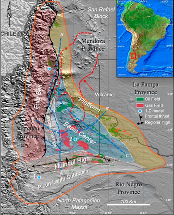
Figure 2 Geological regions of the Neuquén Basin.[19]
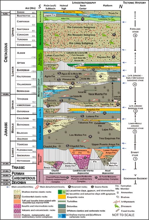
Figure 3 Chronostratigraphic chart of the Neuquén Basin with main reservoirs and source rocks. Tectonic history: cycle climax (solid arrow) versus cycle waning (dotted arrows).[19]


Successive Mesozoic transgressions entering the basin from the west deposited several source rocks, including the Early Jurassic Los Molles Formation (TOC 1%–7%), the Late Jurassic–Early Cretaceous world-class source rock Vaca Muerta Formation (2-9% TOC, hi-quality oil-prone marine kerogen) and the Early Cretaceous Agrio Formation (TOC 2%–5%). Superimposed petroleum systems, combined with different structural settings, gave rise to numerous conventional plays.[19] Conventional plays can be grouped by regions: Hincul High (Jurassic reservoirs in pre-tertiary structures sourced by the Los Molles Fm), Fold Belt (Cretaceous reservoirs on structural traps sourced by Vaca Muerta and Agrio Fms), Basin Center (Cretaceous reservoirs on stratigraphic traps sourced by Vaca Muerta Fm), and the Platform play (Cretaceous reservoirs on stratigraphic traps sourced by Vaca Muerta Fm).[22]
A wide variety of productive reservoirs, embracing clastic, carbonate, and igneous rocks were formed in different tectono-sedimentary cycles. Seals are evaporites associated with desiccation events, although highly cemented layers of clastic units also work effectively. Traps are related to (1) structural types, like anticlinal closures in four directions and faults with closures by juxtaposition; (2) stratigraphic types, associated with unconformities of the sedimentary infill; (3) diagenetic types, related to variations of capillarity; and (4) lateral and vertical changes of facies with primary permeability barriers (Figure 3).[19]
The Neuquén Basin has gone through three main phases of development: conventional, tight, and unconventional. After the gas peak production achieved in 2004, production declined. However, when production from tight reservoirs and lately from shale gas and oil were added, this trend started to change in a reverse and positive direction. Up to date, a total of 4200 conventional exploratory wells have been drilled in the basin, with a high success rate of approximately 54% (considering multiple objectives on wells).[19]
Northern Gulf of Mexico[edit]
Located in the Offshore United States, the northern GOM is a good example of a super basin in a salt-tectonic dominated setting (Figure 4). Its cumulative production is 60 BOE and it stores more than 100 BOE. It includes several petroleum systems representing a wide variety of depositional environments (deep water to aeolian domains) and six tectonostratigraphic phases (Figure 5), three during the Mesozoic and three in the Cenozoic.[23]
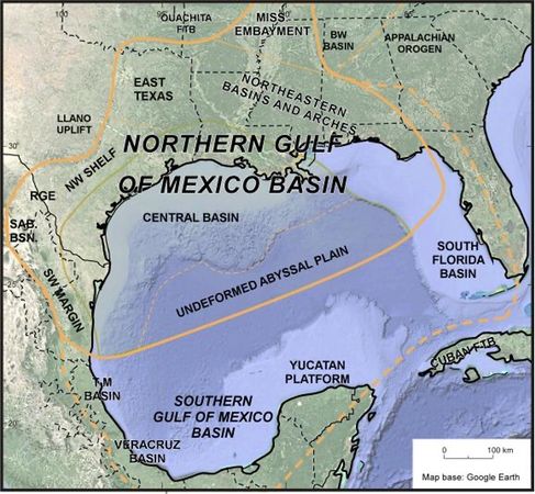
Figure 4 Location map of the United States (northern) Gulf of Mexico Super Basin.[24]
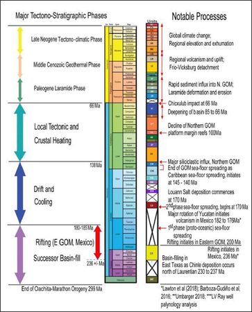
Figure 5 Tectonostratigraphic phases in the Gulf of Mexico Basin.[23]


Three major Mesozoic source rocks deposited during transgressive events. The Oxfordian Smackover Formation has limestones and marls with an average TOC of 3% and a type II kerogen. The Tithonian Cotton Valley- Bossier and Haynesville-Buckner super sequences are characterized by carbonate and some siliciclastic facies, where the TOC ranges 5 to 20% and kerogen is mostly type II. The Cenomanian-Turonian Eagle Ford- Tuscaloosa super sequence has black shales and 4-7% TOC. These rocks also work as unconventional reservoirs. Three main reservoirs are present in this basin. The Wilcox play (Cenozoic), characterized by its high porosity (15%-23%) and permeability (10-100 md), and reservoirs of Jurassic - Cretaceous age that include limestones from James and Andrew Formations and sandstones from the Norphlet Formation, the last one being the largest play in the basin. Retention of oil and gas is conducted by shales, limestones and evaporite seal rocks. Traps occur in diverse styles due to salt tectonics (salt canopy, faulting, diapirs, turtle structures).[23]
The complexity in tectonics and geologic models in this basin led to necessary improvements in seismic imaging, drilling techniques and completion methods.[23]
Permian Basin[edit]
The Permian basin of West Texas and southeast New Mexico (Figure 6) is the largest petroleum producing basin in the United States.[25] It has produced oil for 100 years, with a cumulative production of over 33.4 billion bbl and 118 TCF trillion ft3 of gas as of September 2018.[25] In 2016, EIA estimated remaining proven reserves to exceed 5 billion bbl and 19.1 TCF of natural gas, making it a clear example of a tier one super basin in the world.[26]
It covers more than 220,000 km2 and comprises several component basins and platforms, including the Midland Basin, the Delaware Basin, the Val Verde Basin and the Central basin platform (Figure 6).[25] Recording the collision of North America and Gondwana during the middle Carboniferous, the Permian Basin developed as a foreland basin in the north of the Marathon Ouachita thrust belt.[27][28] The stratigraphy has been substantially influenced by sea-level changes. High sea levels are associated with carbonate shoals in platform margins, whereas lower sea levels were associated with aeolian and fluvial sediments at the shelf margins and to thick turbidite deposits in deep marine environments.[29]
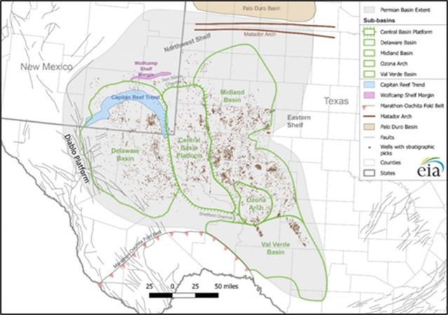
Figure 6 Location map of the Permian Basin, with its major structural features and drilled wells.[25]
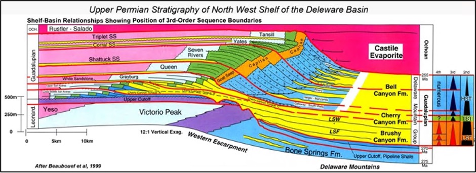
Figure 7 Upper Permian Stratigraphy of North West Shelf of the Delaware Basin.[30]


Up to 8 petroleum systems and 32 plays have been defined in the basin.[28][31] The Guadalupian petroleum systems (Upper Permian, Figure 7) holds the major bulk of reserves with a cumulative production of 16 Bbbls of cumulative oil as of 2005 with main plays associated with shallow water carbonates and deep-water sandstones on stratigraphic traps.[28] Although this system holds the largest production, it is the Wolfcamp Shale that has lately drawn attention, arising as a prospective unconventional play revitalizing the basin. The Wolfcampian-age organic-rich shale formation extends over all three sub-basins in the Permian Basin.[25] Hydrocarbon resources exceed 19 Bbbls of oil, 16 TCF of natural gas, and 1.6 billion barrels of natural gas liquids (NGL), making it one of the largest hydrocarbon plays in the country as of October 2018. TOC content ranges from less than 2% up to 8% and kerogen is mostly type II with a type III contribution.[32][33][34] Fracture associated porosity varies between 2% and 12%; however, average permeability is as low as 10 millidarcies, which requires multistage hydraulic fracturing.[28]
After more than a decade of producing unconventional reservoirs, the Permian Basin shows that additional pipelines are required to deliver large volumes of gas, and the impact on projected reserves when closely spaced horizontal wells are produced simultaneously.[35]
See also[edit]
- 2021 Middle East Wiki Write Off
- Fault seal analysis for reservoir development
- Structural restoration
- Condensate banking effect
References[edit]
- ↑ 1.00 1.01 1.02 1.03 1.04 1.05 1.06 1.07 1.08 1.09 1.10 1.11 1.12 1.13 1.14 1.15 1.16 1.17 Fryklund, B., and P. Stark, 2020, Super basins-New paradigm for oil and gas supply: AAPG Bulletin, v. 104, p. 2507-2519.
- ↑ 2.00 2.01 2.02 2.03 2.04 2.05 2.06 2.07 2.08 2.09 2.10 2.11 2.12 2.13 2.14 2.15 2.16 2.17 2.18 2.19 Sternbach, C.A., 2020, Super basin thinking: Methods to explore and revitalize the world’s greatest petroleum basins: AAPG Bulletin, v. 104, p. 2463-2506
- ↑ Vail, P. R., and R. M. Mitchum, 1979, Global cycles of relative changes of sea level from seismic stratigraphy, in J. S. Watkins, L. Montadert, P. W. Dickerson, eds., Geological and geophysical investigations of continental margins: AAPG Memoir 29, p. 469–472.
- ↑ Haq, B., J. Hardenbol, and P. R. Vail, 1987, Chronology of fluctuating sea levels since the Triassic: Science, v. 235, no. 4793, p. 1156–1167, doi:10.1126/science.235.4793.1156.
- ↑ Sorkhabi, R., 2016, Rich petroleum source rocks, GeoExPro, v. 6, no. 6, p. 16–22.
- ↑ Dolson, J. C., 2016, Understanding oil and gas shows and seals in the search for hydrocarbons: Cham, Switzerland, Springer, 486 p., doi:10.1007/978-3-319-29710-1.
- ↑ Dolson, J. C., 2017, Hunting for NULFs: GeoExPro Magazine, v. 14, no. 2, p. 30–33.
- ↑ Halbouty, M. T., 1986, Basins, and new frontiers: An overview, in M. T. Halbouty, ed., Future petroleum provinces of the world: AAPG Memoir 40, p. 1–10.
- ↑ Halbouty, M. T., 2003, Giant oil and gas fields of the decade 1990–1999: AAPG Memoir 78, 340 p., doi:10.1306/M78834.
- ↑ Levorsen, A. I., 1943, Discovery thinking: AAPG Bulletin, v. 27, no. 7, p. 887–928
- ↑ Sloss, L. L., 1963, Sequences in the Cratonic interior of North America: Geological Society of America Bulletin, v. 74, no. 2, p. 93–113, doi:10.1130/0016-7606(1963)74[93: SITCIO]2.0.CO;2.
- ↑ Sloss, L. L., 1984, Comparative anatomy of Cratonic unconformities, in Interregional unconformities and hydrocarbon accumulation: AAPG Memoir 36, p. 1–6.
- ↑ Foster, N. H., and E. A. Beaumont, 1990a, Structural traps: Atlas of oil and gas fields: AAPG Treatise of Petroleum Geology, v. 1–8, 2520 p.
- ↑ Foster, N.H., and E. A. Beaumont, 1990b, Stratigraphic traps: AAPG Treatise of Petroleum Geology, v. 1-3, 1100 p.
- ↑ Derby, J., R. Fritz, S. Longacre, W. Morgan, andC.A. Sternbach, 2012, eds., The great American carbonate bank: The geology and economic resources of the Cambrian-Ordovician Sauk Megasequence of Laurentia: AAPG Memoir 98, 504 p.
- ↑ Sternbach, C. A., 2012, Petroleum resources of the great American carbonate bank, in J. Derby, R. Fritz, S. Longacre, W. Morgan, and C. A. Sternbach, eds., The great American carbonate bank: The geology and economic resources of the Cambrian-Ordovician Sauk Megasequence of Laurentia: AAPG Memoir 98, 504 p.
- ↑ Sternbach, C. A., 2017a, Lessons from a decade of discovery thinking forums.
- ↑ Sternbach, C. A., 2017b, Petroleum resources of the great American carbonate bank: Exercising unconformity thinking: AAPG Search and Discovery article 70276,
- ↑ 19.0 19.1 19.2 19.3 19.4 19.5 19.6 19.7 Veiga, R.D., Vergani, G.D., Brisson, I.E, Macellari, C.E., Leanza, H.A., 2020, The Neuquén Super Basin: AAPG Bulletin, v.104, p. 2521-2555.
- ↑ Llambías, E. J., M. Schiuma, D. Velo, M. Barrionuevo, D. Lenge, F. Pángaro, R. Corbera, O. Carbone, and G. Hinterwimmer, 2018, Reservorios del Grupo Choiyoi y Precuyano, in M. Schiuma, G. Hinterwimmer, and G. D. Vergani, eds., Rocas reservorio de las cuencas productivas de Argentina, 2nd ed. [in Spanish]: X Congreso de Exploración y Desarrollo de Hidrocarburos, Mendoza, Argentina, November 5–9, 2018, p. 325–371.
- ↑ Ramos, V. A., M. Naipauer, H. A. Leanza, and M. E. Sigismondi, 2020, An exceptional tectonic setting along the Andean continental margin, in D. Minisini, M. Fantín, I. Lanusse Noguera, and H. A. Leanza, eds., Integrated geology of unconventionals: The case of the Vaca Muerta play, Argentina: AAPG Memoir 121, p. 25–38, doi:10.1306/13682222M1202855.
- ↑ Vergani, G., C. Arregui, and O. Carbone, 2011, Sistemas petroleros y tipos de entrampamientos en la Cuenca Neuquina, in H. A. Leanza, C. Arregui, O. Carbone, J. C. Danieli, and J. M. Valiés, eds., Geología y recursos naturales de la provincia del Neuquén [in Spanish]: Relatorio del XVIII Congreso Geológico Argentino, 2 al 6 de Mayo de 1011, Neuquén: Buenos Aires, Asociación Geológica Argentina, p. 645 656.
- ↑ 23.0 23.1 23.2 23.3 Snedden, J.W., Cunningham, R.C., Virdell, J.W., 2020, The northern Gulf of Mexico offshore super basin: Reservoirs, source rocks, seals, traps, and successes: AAPG Bulletin, v. 104, p. 2603-2642.
- ↑ Ewing, T.E.; Galloway, W.E, 2019, Evolution of the Northern Gulf of Mexico Sedimentary Basin. The sedimentary basins of the United States and Canada (Second edition), Chapter 16, p. 627-694.
- ↑ 25.0 25.1 25.2 25.3 25.4 EIA, 2018, "Permian Basin Geology Review", U.S Energy Information Administration Report.
- ↑ EIA, 2017, U.S. Crude Oil and Natural Gas Proved Reserves, Year-end 2017, U.S. Energy Information Administration report.
- ↑ Frenzel, H. N., et al., 1988, The Permian basin region, in L. L. Sloss, ed., Sedimentary cover—North American craton; U.S.: Boulder, Colorado, Geological Society of America, The Geology of North America, v. D-2, p. 261– 306.
- ↑ 28.0 28.1 28.2 28.3 Dutton, S.P., Kim, E.M., Broadhead, R.F., Raatz, W.D., Breton, C.L., Ruppel, S.C. and Kerans, C., 2005. Play analysis and leading-edge oil-reservoir development methods in the Permian basin: Increased recovery through advanced technologies. AAPG bulletin, 89(5), pp.553-576.
- ↑ Smith, T., 2013. The Permian Basin – A Brief Overview. GEOExpro Vol. 9, No. 6, p. 64
- ↑ Beaubouef, R.T., Rossen, C., Zelt, F.B., Sullivan, M.D., Mohrig, D.C. and Jennette, D.C., 1999. Field guide for AAPG Hedbergfield research conference-April 15–20, 1999: Deep-water sandstones, Brushy Canyon Formation, West Texas. Continuing Education Course Note Series, 40.
- ↑ Jarvie, D.M., 2018. Petroleum systems in the Permian Basin: Targeting optimum oil production.
- ↑ Gupta, I., Rai, C., Sondergeld, C. and Devegowda, D., 2017, June. Rock typing in Wolfcamp formation. In SPWLA 58th Annual Logging Symposium. Society of Petrophysicists and Well-Log Analysts.
- ↑ Kvale, E.P. and “Wahid” Rahman, M., 2016, August. Depositional facies and organic content of upper Wolfcamp Formation (Permian) Delaware Basin and implications for sequence stratigraphy and hydrocarbon source. In Unconventional Resources Technology Conference, San Antonio, Texas, 1-3 August 2016 (pp. 1485-1495). Society of Exploration Geophysicists, American Association of Petroleum Geologists, Society of Petroleum Engineers.
- ↑ Ward, R. F., C. G. St. C. Kendall, and R. M. Harris, 1986, Upper Permian (Guadalupian) facies and their association with hydrocarbons—Permian basin, west Texas and New Mexico: AAPG Bulletin, v. 70, p. 239– 262.
- ↑ Jones, S., 2019, Making sense of producing gas-oil ratio in unconventional oil reservoirs, video accessed October 19, 2020.