Search results
Jump to navigation
Jump to search
Page title matches
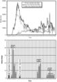
- ...Tectonic and sedimentation model for Morrow sandstone deposition, Sorrento field area, Denver basin, Colorado: The Mountain Geologist, October, p. 180-191.< ...-and-performance_fig9-85.png|Figure 1]] shows the location of the Sorrento field. Structure is contoured on the base of the Pennsylvanian.3 KB (429 words) - 14:19, 11 April 2022
- ...Tectonic and sedimentation model for Morrow sandstone deposition, Sorrento field area, Denver basin, Colorado: The Mountain Geologist, October, p. 180-191.< Morrow sandstones in the Sorrento field are slightly shaly, range in [[grain size]] from very coarse to fine, and a6 KB (769 words) - 17:23, 11 April 2022
- 5 KB (753 words) - 19:58, 18 February 2022
- Planning and logistics are key components for the success of any field party. An important pre-field step is to review previous work. This includes finding and evaluating previ5 KB (730 words) - 22:36, 1 February 2022
Page text matches
- #REDIRECT [[Sorrento field: water saturation]]46 bytes (5 words) - 16:15, 21 November 2014
- #REDIRECT [[Sorrento field: water saturation]]46 bytes (5 words) - 16:17, 21 November 2014
- #REDIRECT [[Sorrento field: water saturation]]46 bytes (5 words) - 16:16, 21 November 2014
- #REDIRECT [[Magnetic field: local variations]]46 bytes (5 words) - 21:19, 14 May 2014
- ...-field) measurement. The E-field is always measured perpendicular to the H-field data. ==The H-field==4 KB (519 words) - 19:57, 27 January 2022
File:Mth14ch04f02.jpg ...nd Conclusions of a Horizontal-drilling Program at South Pass 62 Salt-dome Field, by E. P. Mason, M. J. Bastian, R. Detomo, M. N. Hashem, and A. J. Hildebra(500 × 718 (88 KB)) - 16:08, 7 December 2015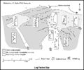
File:M91Ch11FG72.JPG ...= gamma-ray log. Shepherd, M., 2009, Lithofacies maps, in M. Shepherd, Oil field production geology: AAPG Memoir 91, p. 93-98.(800 × 658 (69 KB)) - 15:51, 27 April 2015- #REDIRECT [[Morrow lithofacies and pore types: Sorrento field]]63 bytes (8 words) - 12:35, 4 June 2014
File:Mth14ch07f01.jpg ...ique Horizontal-well Designs Boost Primary and EOR Production, Prudhoe Bay Field, Alaska , by R. S. Tye, B. A. Watson, P. L. McGuire, and M. M. Maguire, Pag(700 × 809 (135 KB)) - 17:34, 7 December 2015
File:M91FG184.JPG ...rom AAPG. From Shepherd, M., 2009, Deltaic reservoirs, in M. Shepherd, Oil field production geology: AAPG Memoir 91, p. 279-288.(800 × 1,134 (191 KB)) - 20:10, 12 August 2015- #REDIRECT [[Sediment thickness and field location maps: Gulf of Mexico example]]80 bytes (11 words) - 21:04, 19 December 2014
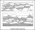
File:M91Ch13FG92.JPG .... From Shepherd, M., 2009, Structural geology: Faults, in M. Shepherd, Oil field production geology: AAPG Memoir 91, p. 107-122.(600 × 517 (60 KB)) - 21:40, 29 April 2015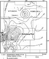
File:BasinCenteredGasFig14.jpg ...Sandstone in the Wattenburg field (modified from Higley et al., 1992). The field is nearly coincident with the 0.9% isoreflectance contour (Higley et al., 1(400 × 478 (53 KB)) - 16:30, 11 March 2015
File:M91Ch11FG71.JPG ...al., 2002). From Shepherd, M., 2009, Lithofacies maps, in M. Shepherd, Oil field production geology: AAPG Memoir 91, p. 93-98.(800 × 629 (79 KB)) - 15:48, 27 April 2015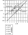
File:Core-log-transformations-and-porosity-permeability-relationships fig5.png ...permeability (run under stress) versus helium porosity from McArthur River Field, Alaska.(912 × 1,127 (19 KB)) - 18:06, 14 January 2014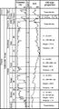
File:Mth14ch07f02.jpg ...ique Horizontal-well Designs Boost Primary and EOR Production, Prudhoe Bay Field, Alaska , by R. S. Tye, B. A. Watson, P. L. McGuire, and M. M. Maguire, Pag(500 × 923 (106 KB)) - 17:50, 7 December 2015
File:Mth14ch04f03.jpg ...nd Conclusions of a Horizontal-drilling Program at South Pass 62 Salt-dome Field, by E. P. Mason, M. J. Bastian, R. Detomo, M. N. Hashem, and A. J. Hildebra(500 × 495 (47 KB)) - 16:09, 7 December 2015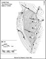
File:M91Ch13FG84.JPG .... From Shepherd, M., 2009, Structural geology: Faults, in M. Shepherd, Oil field production geology: AAPG Memoir 91, p. 107-122.(600 × 766 (134 KB)) - 21:34, 29 April 2015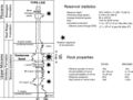
File:Mth14ch02f03.jpg ...Turbidite Reservoir--The ARCO-DOE 91X-3 Horizontal Well Project, Yowlumne Field, San Joaquin Basin, California in AAPG Methods in Exploration No. 14: Horiz(700 × 529 (75 KB)) - 15:26, 4 December 2015
File:Mth14ch02f08.jpg ...Turbidite Reservoir--The ARCO-DOE 91X-3 Horizontal Well Project, Yowlumne Field, San Joaquin Basin, California in AAPG Methods in Exploration No. 14: Horiz(400 × 465 (28 KB)) - 20:19, 4 December 2015


