Search results
Jump to navigation
Jump to search
Page title matches
- ...thinking: Methods to explore and revitalize the world’s greatest petroleum basins]: AAPG Bulletin, v. 104, p. 2463-2506</ref> ...tain favorable geological conditions are needed for basins to become super basins, a key for this transformation includes changes in paradigms and technology27 KB (3,791 words) - 19:35, 11 October 2022
- | chapter = Petroleum systems of Turkish basins ...Mediterranean, 2) the Aegean, 3) the sea of Marmara, and 4) the Black Sea basins ([[:file:M106Ch13Fig02.jpg|Figure 2]]).52 KB (7,769 words) - 20:28, 18 January 2017
- ...ceous and lower [[Tertiary]] reservoirs within several large basins. These basins, the product of rifting of Africa from South America in the Early Cretaceou ...e rock]]s for the five source-distinctive groups of oils in these marginal basins.8 KB (1,086 words) - 22:16, 15 February 2022
- ...[mudstone]] and dolomite interbedded deposits are primarily found in these basins. Organic-rich shales are mainly distributed in the Lower Permian Fengcheng6 KB (850 words) - 17:56, 20 December 2023
- #REDIRECT [[Oil correlation case history: Brazilian offshore basins]]69 bytes (8 words) - 18:49, 29 January 2014
Page text matches
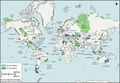
File:GiacomoneEtAlFigure1.jpg ...and remaining recoverable oil and gas) are shown in green. Tier two super basins (those with less than 5 billion BOE of cumulative production or remaining r(868 × 600 (145 KB)) - 20:51, 28 October 2021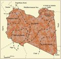
File:M106Ch04Fig03.jpg Sedimentary basins of Libya (productive basins, future prospective) 200 km (124.3 mi). From Hassan, H. S., and C. C. G. Ke(700 × 676 (77 KB)) - 20:13, 28 March 2016- #REDIRECT [[Oil correlation case history: Brazilian offshore basins]]69 bytes (8 words) - 18:49, 29 January 2014
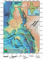
File:M114CH03FG01.jpg ...points show the distribution of discovered fields in the Barmer and Cambay basins and their relative phase ratios of gas, oil, and condensate. From AAPG Memo(691 × 944 (147 KB)) - 17:46, 4 January 2019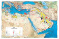
File:M106IntroFig01.jpg Basins, fields, and structures data from IHS International Energy Database (Januar(1,932 × 1,288 (1.62 MB)) - 18:25, 18 February 2016
File:M106Ch13Fig07.jpg ...Siyako, 2005). From Derman, Ahmet Sami, 2014, Petroleum systems of Turkish Basins, in L. Marlow, C. Kendall, and L. Yose, eds., Petroleum systems of the Teth(700 × 331 (49 KB)) - 20:01, 5 July 2016
File:Hydrocarbon reservoirs associated layered intrusive bodies.pdf ...ll type intrusives are important reservoirs of hydrocarbons in sedimentary basins due(1.88 MB) - 16:30, 25 June 2015- ....<ref name=ch04r60>MacQueen, R. W., and D. A. Leckie, eds., 1992, Foreland Basins and Fold Belts: [http://store.aapg.org/detail.aspx?id=143 AAPG Memoir 55],2 KB (315 words) - 18:44, 21 March 2022
File:M106Ch07Fig1.jpg Surface geology and locations of sedimentary basins, structural elements, key petroleum wells, and hydrocarbon fields in Jordan(700 × 857 (97 KB)) - 20:28, 18 April 2016
File:M106Ch13Fig11.jpg ...0 km (6.2 mi). From Derman, Ahmet Sami, 2014, Petroleum systems of Turkish Basins, in L. Marlow, C. Kendall, and L. Yose, eds., Petroleum systems of the Teth(700 × 637 (109 KB)) - 20:03, 5 July 2016- Quantitative fault seal analysis is a proven tool in numerous basins. There are, however, limitations. ...aults in [[foreland fold and thrust belts]] or [[strike-slip]] basins. All basins in which quantitative fault seal analysis has been proven to date are domin3 KB (398 words) - 17:35, 29 March 2022
- * The dominance of gas in the deeper parts of basins may reflect seal capacity as well as [[maturation]]. ==Gas and oil distribution in basins==5 KB (765 words) - 20:55, 31 March 2022
File:FG11.JPG ..., v 96, no. 11, Tectonostratigraphic evolution of the Jurassic extensional basins of the eastern southern Alps and Adriatic foreland based on an integrated s(800 × 648 (291 KB)) - 15:04, 5 August 2014
File:M106Ch13Fig01.jpg ...km (186.4 mi). From Derman, Ahmet Sami, 2014, Petroleum systems of Turkish Basins, in L. Marlow, C. Kendall, and L. Yose, eds., Petroleum systems of the Teth(700 × 513 (90 KB)) - 19:29, 5 July 2016- In many basins the major control on hydrocarbon column heights is not the [[top seal displ ...sland Basin]] and [[North Sea]] are only two of numerous examples. In some basins, this regional seal is lacking or limited. In the Gulf Coast, the [[North F4 KB (556 words) - 20:56, 31 March 2022
- ==Basins, depocenters, and minibasins==4 KB (518 words) - 16:42, 18 February 2022
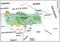
File:M106Ch13Fig02.jpg ...et al., 2005.) From Derman, Ahmet Sami, 2014, Petroleum systems of Turkish Basins, in L. Marlow, C. Kendall, and L. Yose, eds., Petroleum systems of the Teth(700 × 491 (61 KB)) - 19:34, 5 July 2016- * [[Oil correlation case history: Brazilian offshore basins]]964 bytes (130 words) - 16:32, 24 June 2015
- 2 KB (346 words) - 21:06, 3 February 2022
- ...ce stratigraphic concepts applied to Paleogene outcrops, Gulf and Atlantic basins, in Wilgus, C. K., Hastings, B. S., Posamentier, H. M., Van Wagoner, J., Ro ...al_analysis_of_clastic_depositional_systems#Lacustrine_deposits|lacustrine basins]]. The numbers in the cross sections correspond to the numbers in the table4 KB (486 words) - 14:57, 4 February 2022


