Search results
Jump to navigation
Jump to search
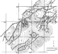
File:Subsurface-maps fig1.png Structure map of the top of the T5 marker, Frlo Formation, Brazoria County, Texas. (After Bebout et al., 1978.)(1,865 × 1,746 (308 KB)) - 20:42, 14 January 2014
File:Three-dimensional-seismic-method fig2.png {{copyright|a marine 3-D survey and (b) a time-structure map of a marker horizon derived from the 3-D volume of migrated data. (Data courtesy of Wes ...e slices. Copyright: a marine 3-D survey and (b) a time-structure map of a marker horizon derived from the 3-D volume of migrated data. (Data courtesy of Wes(1,338 × 2,684 (369 KB)) - 19:36, 14 January 2014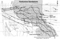
File:Mth14ch02f01.jpg Structure map of Yowlumne field drawn on the N-point marker, a regional correlation horizon that marks the approximate top of the Steve(700 × 457 (103 KB)) - 23:18, 3 December 2015
File:ST53Part01Pg12A.jpg ...e amount of fold growth that occurred subsequent to the deposition of that marker. As a result, younger horizons have narrower fold limbs than do older horiz(750 × 411 (83 KB)) - 16:36, 28 July 2015- ...le:petroleum-systems_fig3-10.png|300px|thumb|{{figure number|4}}Biological marker analysis by Mackenzie et al.<ref name=ch03r6 /> and Hughes et al.<ref name= ...03r6>Mackenzie, A., S., Maxwell, J., R., Coleman, M., L., 1983, Biological marker and isotope studies of North Sea [[crude oil]]s and sediments: Proceedings9 KB (1,184 words) - 18:46, 3 March 2016
- ...t, W. K., J. M. Moldowan, and R. W. Jones, 1980, Application of biological marker chemistry to petroleum exploration: Proceedings of the 10th World Petroleum Biological marker analysis ([[:file:petroleum-systems_fig3-16.png|Figure 5A]]) from the main10 KB (1,241 words) - 20:11, 25 January 2022
- ...w the Niobrara. Therefore, although the Mesa Verde provides good [[seismic marker]] beds, the underlying Mancos and Niobrara ...duce. [[Seismic data]] are useful in delineating these faults because good marker beds are usually present below the Niobrara. The fault can then be projecte7 KB (962 words) - 16:03, 18 February 2022
- ...uality-and-performance_fig9-86.png|Figure 2]], structure [[contour]]s on a marker bed above the [[Morrow Sandstone]] reflect the irregular thickness of the s3 KB (429 words) - 14:19, 11 April 2022
- ...e slices. Copyright: a marine 3-D survey and (b) a time-structure map of a marker horizon derived from the 3-D volume of migrated data. (Data courtesy of Wes ...s). The time slices allow the interpreter to generate [[contour]] maps for marker horizons ([[:file:three-dimensional-seismic-method_fig2.png|Figure 2]]). Th8 KB (1,201 words) - 20:24, 21 January 2022
- ...alysis#Sidewall_core_analysis|sidewall core]], or a significant geological marker. To use this depth in interpreting geological structure, the depth must be * ''m'' = marker depth of interest17 KB (2,363 words) - 16:49, 20 January 2022
- ...[[cross section]]s that include the key well. Use a region/fieldwide time marker at the top of the reservoir as the datum.4 KB (547 words) - 18:09, 1 April 2022
- td.diff-marker {4 KB (499 words) - 17:00, 31 March 2014
- *'''Creating a delete marker'''5 KB (543 words) - 23:45, 8 January 2015
- ...g the study area sequence chart, to the same time scale using the bioevent marker taxa or zonal assemblages. ...tudies have been calibrated to the same time scale using the same bioevent marker taxa and are in turn correlated to the global foraminiferal zones and magne13 KB (1,871 words) - 20:06, 24 February 2022
- ...oc.org.uk/ks3/gsl/education/resources/rockcycle/page3598.html intrusives], marker horizons5 KB (636 words) - 21:47, 1 February 2022
- ...and K. W. Dunham, 1986, Oil generation in the Michigan basin: a biological marker and carbon isotope approach, in D. Leythaeuser, and J. Rullkötter, eds., A5 KB (718 words) - 17:24, 15 February 2022
- ...t, W. K., J. M. Moldowan, and R. W. Jones, 1979, Application of biological marker chemistry to petroleum exploration, in Proceedings of the Tenth World Petro5 KB (784 words) - 15:28, 15 February 2022
- ...elate between wells that have biostratigraphic-time correlations, well log marker-bed correlations, and the global sea cycle chart.6 KB (845 words) - 16:53, 4 February 2022
- ...fig1.png|300px|thumb|{{figure number|1}}Structure map of the top of the T5 marker, Frlo Formation, Brazoria County, Texas. (After Bebout el al.)<ref name=pt0 ...ow [[Contours|lines of equal elevation or depth]] for a selected [[Markers|marker horizon]] ([[:file:subsurface-maps_fig1.png|Figure 1]]) (see [[Evaluating s22 KB (3,076 words) - 13:56, 24 January 2022
- ::will automatically create a footnote marker that will link to the original reference: Doe<ref name=Doe_1986 />8 KB (1,305 words) - 16:59, 27 May 2015


