Search results
Jump to navigation
Jump to search
Page title matches
- | chapter = West Texas (Permian) Super Basin Unconventional Resources: Exploration, Discovery, and ...elopment of hydrocarbons in unconventional resource reservoirs in the West Texas Super Basin occurred gradually for decades. Knowledge about the basin and p157 KB (23,278 words) - 18:36, 16 January 2024
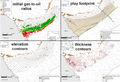
- ...tural gas, and condensate/natural gas liquids play in southwest to central Texas (Fig. 1). The Eagle Ford play extends from the Maverick Basin northeast to ...ly northwest to southeast trend. Eagle Ford oil is also widely produced in Texas and parts of Louisiana from wells in the overlying Austin Chalk.10 KB (1,550 words) - 21:50, 3 March 2022
- ...Texas Natural Resources Information, U.S. Geological Survey, University of Texas Bureau of Economic Geology<ref name=US2015>U.S. Energy Information Administ ...tural gas, and condensate/natural gas liquids play in southwest to central Texas, extending from the Maverick Basin northeast to the Karnes Trough, with som11 KB (1,594 words) - 19:15, 8 February 2024
- ...TotalNGP2000-2020 Barnett2019-20CommRpt.jpg|200px|thumb|{{figure number|1}}Texas Barnett Shale total natural gas production 2000 through July 2020, https:// ...TotalNGP2000-2020 Barnett2019-20CommRpt.jpg|200px|thumb|{{figure number|2}}Texas Barnet Shale condensate production 2000 through July 2020, https://www.rrc.3 KB (414 words) - 22:15, 2 June 2021
- ...ales span more than 16 counties and parishes along the boundary of eastern Texas and western Louisiana. Basement structures and salt movement influenced car ...Haynesville can be found at the Texas Railroad Commission https://www.rrc.texas.gov/oil-and-gas/major-oil-and-gas-formations/haynesville-bossier-shale/ and4 KB (628 words) - 23:05, 3 March 2022
Page text matches
File:Figure1EagleFord2019-20CommRept.jpg ...Texas Natural Resources Information, U.S. Geological Survey, University of Texas Bureau of Economic Geology (from U.S. EIA, January 21, 2015).(432 × 296 (123 KB)) - 21:52, 6 April 2021- ...ww-odp.tamu.edu/publications/tnotes/tn30/tn30_2.htm Ocean Drilling Program Texas A&M University article]258 bytes (35 words) - 16:37, 27 March 2015
File:M91FG193.JPG ...l for channelized turbidites and a basin-floor fan complex, Brushy Canyon, Texas. From Beaubouef (1999). Reprinted with permission from the AAPG.(800 × 1,075 (131 KB)) - 16:25, 14 August 2015
File:Paleontology fig3.png ...on of Rodessa Formation lithofacies at Running Duke Field, Houston County, Texas. Cores are indicated by solid vertical lines. (From Scott, 1990.)(1,973 × 1,229 (190 KB)) - 17:38, 14 January 2014- ...w.rrc.state.tx.us/oil-gas/major-oil-gas-formations/permian-basin/ State of Texas page, including drilling and production statistics]312 bytes (40 words) - 16:12, 15 December 2014
File:Subsurface-maps fig1.png Structure map of the top of the T5 marker, Frlo Formation, Brazoria County, Texas. (After Bebout et al., 1978.)(1,865 × 1,746 (308 KB)) - 20:42, 14 January 2014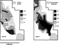
File:Subsurface-maps fig6.png ...he San Andres Formation reservoir, Jordan field, Ector and Crane Counties, Texas. Contours in PV fraction-feet. (After Major and Holtz, 1989.)(1,944 × 1,484 (237 KB)) - 20:42, 14 January 2014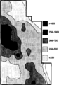
File:Subsurface-maps fig7.png ...he San Andres Formation reservoir, Jordan field, Ector and Crane counties, Texas. Contours in MSTB/year/acre. (After Major and Holtz, 1989.)(944 × 1,353 (62 KB)) - 20:42, 14 January 2014
File:FG18CoreSt63Appendix3.JPG ...nate reservoir: Fullerton Clear Fork (Lower Permian) field, Permian Basin, Texas: AAPG Studies in Geology 63.(600 × 890 (315 KB)) - 16:10, 29 June 2015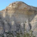
File:Eagle-ford-gets-spotlight04.jpg West Texas' Lozier Canyon offers an opportunity to examine Eagle Ford Shale outcrops a(400 × 400 (80 KB)) - 16:20, 18 June 2014
File:Figure3AustinChalk2019-20CommRept.jpg ...recoverable oil and gas resources in the Austin Chalk and related units in Texas and Louisiana. (Pitman et al., 2020).(1,789 × 1,110 (895 KB)) - 21:21, 5 April 2021
File:MainPageFG18CoreSt63Appendix3.jpg ...nate reservoir: Fullerton Clear Fork (Lower Permian) field, Permian Basin, Texas: AAPG Studies in Geology 63. Used on Core description article.(400 × 400 (104 KB)) - 16:14, 29 June 2015
File:M91Ch11FG70.JPG ...on a horizon display, late Pennsylvanian to Early Permian, Baylor County, Texas (from Burnett, 1996). From Shepherd, M., 2009, Lithofacies maps, in M. Shep(600 × 353 (134 KB)) - 15:46, 27 April 2015
File:Figure1AustinChalk2019-20CommRept.jpg Stratigraphic columns for Upper Cretaceous rocks from South Texas to Mississippi (Pearson, 2012). Shows reservoir rocks (Austin Chalk, Tokio(579 × 499 (288 KB)) - 20:54, 5 April 2021
File:M91FG117.JPG ...aps from the West Cornelius reservoir, North Markham-North Bay City field, Texas. In this strand-plain reservoir, east-northeastndashwest-southwest-oriented(800 × 689 (66 KB)) - 21:32, 12 August 2015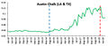
File:Figure2AustinChalk2019-20CommRept.jpg Austin Chalk production (combining Texas and Louisiana) from January 2010 through September 2020 in millions of barr(468 × 202 (56 KB)) - 21:13, 5 April 2021
File:M109CH01Monocrystalline.jpg Lower Cretaceous Travis Peak Formation, Eastland County, Texas, Monocrystalline quartz grain with exceptionally abundant vacuoles (probabl(656 × 439 (87 KB)) - 20:20, 23 January 2019
File:M91FG199.JPG ...rmian San Andres dolomite of the northern Delaware basin in New Mexico and Texas (after Shinn, 1983). Repeated transgression and regression create cycles of(800 × 1,089 (126 KB)) - 13:11, 20 August 2015- ...TotalNGP2000-2020 Barnett2019-20CommRpt.jpg|200px|thumb|{{figure number|1}}Texas Barnett Shale total natural gas production 2000 through July 2020, https:// ...TotalNGP2000-2020 Barnett2019-20CommRpt.jpg|200px|thumb|{{figure number|2}}Texas Barnet Shale condensate production 2000 through July 2020, https://www.rrc.3 KB (414 words) - 22:15, 2 June 2021
- ...-solutions.com/sunstar/geology/Permian/PermianTX.htm Permian reefs in west Texas, USA] ...geologicformations.htm Permian Reefs in Guadalupe Mountains National Park, Texas, USA] A significant part of of this park was donated to the country by Wal2 KB (298 words) - 21:30, 21 November 2014


