Cuba: Geologic history
| Geology of Cuba | |
| |
| Series | Studies in Geology |
|---|---|
| Author | Georges Pardo |
| Link | Web page |
| Store | AAPG Store |

The geology of Cuba has been a challenge to geologists because of features such as the presence of well-preserved Jurassic ammonites, the rich Tertiary foraminiferal faunas (including remarkable Paleogene orbitoids), the gigantic Upper Cretaceous rudistids, the spectacular limestone Mogotes of Pinar del Rio, the extensive outcrops of ultrabasic igneous rocks, the chromite and manganese deposits, and the extraordinary structural complexity. In addition to these features, the numerous petroleum seeps, many of them coming out of basic igneous rock, have attracted much attention.
Geologic history
The summary here of the geological history of Cuba has been strongly influenced by the geology of central Cuba. However, the timing of the events was not [isochronous] along the whole length of the orogen.
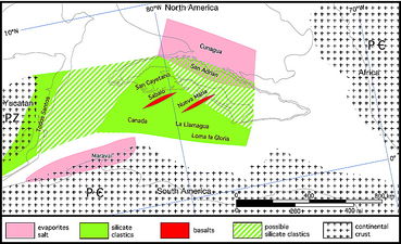
Figure 1 Cuba. 163 Ma: Callovian. PC = Precambrian; PZ = Paleozoic.[1]
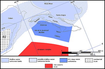
Figure 2 Cuba. 144 Ma: early Tithonian.[1]
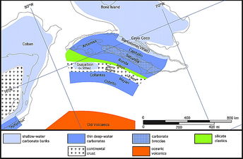
Figure 3 Cuba. 132 Ma: Valanginian.[1]
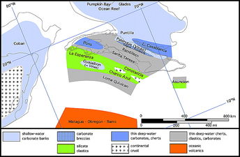
Figure 4 Cuba. 110 Ma: Aptian.[1]
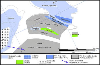
Figure 5 Cuba. 94 Ma: Cenomanian.[1]


Paleogeographic maps (Figures 1-10) illustrate the possible past distribution of the most characteristic stratigraphic units. These maps are on a continental drift base modified from the [Ocean Drilling Stratigraphic Network (ODSN) created in 2005 by the University of Bremen, with Florida occupying a fixed position. In all maps, Cuba is shown in its present position relative to Florida, although different parts of the island came from various places.
In these maps, autochthonous nappes, allochthonous nappes, and subduction will be used to describe, respectively, the thrusting toward the continent of the sediments, the basic igneous-volcanic rocks, and the subduction. Supported by observations in Cuba and elsewhere, these maps show subduction as the main cause of the uplift of a convergent continental margin or ocean floor, whereas the nappes are the result of sedimentary or volcanic cover sliding away, under the force of gravity, from the area uplifted by subduction.
Burke,[2] Pindell and Barrett,[3] Iturralde-Vinent,[4] Cobiella-Reguera,[5] Garcia-Casco et al.,[6] Giunta et al.,[7] and Pindell et al.[8] have interpreted the Cretaceous Cuban subduction as northeast dipping and reversing polarity to the southwest during the Late Cretaceous. Cuba's geology suggests that the subduction was continuously north dipping, and this concept is discussed in more detail below.
The paleogeographic history presented here is in general agreement with that of Pszczolkowski.[9] Differences are, for example, the position of the Guajaibon–Sierra Azul belt, the origin of the middle Cretaceous quartzose clastics, and the dip of the subduction zone. Stratigraphic unit names followed by an asterisk (i.e., Capitolio*) were originally named by Gulf Oil Company geologists and might, or might not, be used today in the same context.
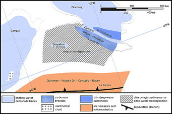
Figure 6 Cuba. 80 Ma: Santonian.[1]
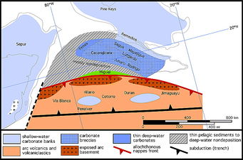
Figure 7 Cuba. 67 Ma: Maastrichtian.[1]
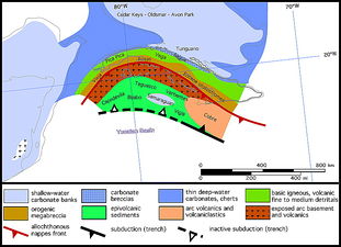
Figure 8 Cuba. 50 Ma: top lower Eocene.[1]
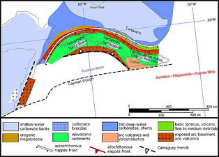
Figure 9 Cuba. 40 Ma: base upper Eocene.[1]
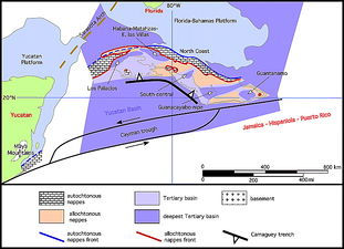
Figure 10 Cuba. Present.[1]


Early(?)-Middle Jurassic
Very little is known about the pre-Late Jurassic history of the island except that the lower part of the San Cayetano clastics might be Lower Jurassic (163 Ma; Figure 1). The San Cayetano must have been deposited over an initially rifting basement that probably included fragments of continental crust as well as basaltic flows. This is supported by the sub-Neocomian granodioritic klippen of La Rana, Tres Guanos, and Rancho Veloz and the occurrences of the El Sabalo and Nueva Maria tholeitic basalts underlying the sedimentary section of the northern Rosario belt and Cifuentes* belt of the Sierra de Camajan.
It can also be assumed that, prior to the deposition of the Upper Jurassic rocks, a large area of basement was exposed to the northwest, extending from Florida's Sarasota arch to the Maya Mountains. The nature of this basement is generally unknown, but it must have been of granitic to granodioritic composition as indicated by the arkosic nature of the San Cayetano Formation. In south Florida, several wells have penetrated an undifferentiated Jurassic–Triassic volcanic section and Paleozoic granite. The basement must also have included Paleozoic sediments known to outcrop in the Maya Mountains, present as fragments in San Cayetano conglomerates, and, perhaps, as exotics in the Cayo Coco Formation. The bulk of the San Cayetano Formation accumulated south of this basement high.
The San Cayetano clastics could have originated from the Gulf of Mexico, as well as nearby South America. As already mentioned, some studies indicate that the southwestern part of the San Cayetano originated from the southwest, and the northeastern part originated from the northeast. Structural complexity makes source direction hard to evaluate.
Toward the northeast, sub-Upper Jurassic sediments have not been observed in situ, but the Cunagua salt suggests the presence of an evaporite basin correlating with the Louann Salt and Maraval evaporites and, possibly, as suggested by the San Adrian Formation, interfingering with the San Cayetano.
As rifting continued, new oceanic crust formed with outpouring of basalts (El Sabalo) and serpentinization of the upper mantle.
Tithonian
In the Tithonian (144 Ma; Figure 2) section, sediments vary from the shallow-water carbonate and evaporite deposits of Wood River, Punta Alegre*, and Guani* in the north, toward Florida and the Bahamas, to shallow-water normal marine limestones of the Trocha* Group to the south in the Las Villas* belt. Toward Pinar del Rio, thick, massive, shallow-water limestone of the Guasasa Formation accumulated over a northward-thinning wedge of San Cayetano, Jagua, and possibly, basement. Farther south, the thin-bedded limestones of Cobrito, Sauco, and Isla de la Juventud marbles were deposited over the lower Oxfordian thin quartzose sandstones of La Llamagua, Loma la Gloria, and Agua Santa Formations. The outpouring of basalt continued forming the slightly younger Nueva Maria Formation in the southern Loma Camajan. Farther south, rifting produced ultrabasic oceanic crust.
Neocomian
Shallow-water platform carbonates, with some evaporites, continued to accumulate in the north (coastal area, Yaguajay* belt). Elsewhere in central and western Cuba (Las Villas*, southern Rosario belts), the water was markedly deeper as indicated by the deposition of the Capitolio* and Artemisa Formations containing abundant nannoplankton (commonly rock forming) and other pelagic forms.
Some tectonic activity extended into the Neocomian (132 Ma), possibly associated with the rifting, and uplifted blocks south of the Yaguajay* belt. The result was denudation of previously deposited sediments as indicated by northward shedding of carbonate clastics (Sabanilla* Formation), a southward increase in basement exposures (La Rana, Tres Guanos, Rancho Veloz), and deposition of the Jobosi* arkosic conglomerate. This basement could have been derived from a continental block, here named the La Rana block (after the best exposures) and similar to the Maya or Chortis blocks, that was overridden by later nappes.
In central Cuba, the Upper Jurassic and Neocomian beds were only partially eroded. In western Cuba, shallow-bank carbonates, similar to those of the Vinas* Group, accumulated atop the La Rana granodiorite horst and formed the Guajaibon–Sierra Azul belt. South of the La Rana basement horst, deep-water limestones of the Mayari, Collantes, and Cobrito Formations were deposited and preserved.
Farther south, rifting continued, accompanied by outpouring of tholeites and other basic to ultrabasic material forming a layered oceanic basement consisting of peridotite, gabbro, sheeted dikes, pillow basalts (old volcanics of the Domingo* sequence), and associated sediments. Although some genetic relationship exists between the Domingo* sequence and the El Sabalo–Nueva Maria lithologies, these belong to two entirely different provinces. El Sabalo and the Nueva Maria Formations, like the granodiorites, belong to the autochthonous nappes and were at the continental margin, whereas the Domingo* sequence forms the base of the allochthonous nappe and is entirely oceanic.
Barremian
During the Barremian, deposition of platform carbonates continued in the north, grading from shallow-water algal types, with fewer evaporites, to breccias. South, west, and possibly east of the Bahamas Platform, deep-water sedimentation of pelagic (nannoplankton) carbonates continued. However, because of the late Neocomian tectonic activity, conglomerates, derived from the previously deposited limestones in the Las Villas* belt and from the exposed granitic basement in the Cifuentes* belt to the south, became common. No Barremian sediments were deposited in some of the southern areas. However, the basaltic to intermediate flows possibly continued to accumulate over the southern part of the basic igneous basement.
Aptian
During the Aptian (110 Ma; Figure 4), deposition continued to be shallow-water marine along the north coast (Yaguajay* belt) with, farther to the north (Cayo Coco area) and as far as Oriente (Gibara area), some pelagic influence (Casablanca Group). Toward central and western Cuba, conditions continued to be pelagic. The pelagic and shallow-water conditions were separated by a conglomeratic breccia zone (Sagua la Chica* belt) representing a forereef facies, although reefs themselves are not common in outcrops.
There was an influx of quartz- and mica-rich turbiditic detritus, possibly from the erosion of the previously formed basement high, which formed the La Esperanza, Polier, and Constancia* Formations. A southern Guajaibon–Sierra Azul carbonate bank may have been deposited.
Toward the south, the close of the Early Cretaceous was characterized by a great outpouring of basaltic flows (Matagua* Formation) over rifted basement. This activity was accompanied toward the north and west (Cifuentes*, southern Rosario, northern Rosario, and La Esperanza belts) by abundant and extensive chert deposits (Calabazar*, Carmita*, and Santa Teresa* Formations).
Albian-Cenomanian
Except for the Yaguajay* belt along the north coast where platform carbonates accumulated, deep-water pelagic deposition continued during the Albian to Cenomanian (93 Ma; Figure 5). In the south, volcanic activity contributed silica to the seawater, which led to the deposition of primary radiolarian cherts (Calabazar*, Carmita, and Santa Teresa) below the carbonate compensation depth. Whereas noncalcareous detritus was absent over most of the northern area, volcanic-derived clays became increasingly abundant toward the south (Santa Teresa* Formation). The Rana granodiorite high was still active, providing material for the Chaco Azul Formation. The position of the Vinas* type carbonates of the Guajaibon–Sierra Azul belt is problematic.
To the north, as during the Aptian–Albian, the shallow carbonate banks continued to be separated from the pelagic, deep-water sediments to the south by a zone of carbonate-derived clastics, which shifted progressively southward; carbonate turbidites became increasingly abundant (Calabazar* and Mata* formations). In the Florida Straits, carbonate deposition did not keep up with subsidence as indicated by the increase in pelagic deposits, including chert (upper Casablanca Group).
Toward the south, the volcanic activity that formed the lower Cabaiguan* sequence decreased markedly, and argillaceous, calcareous sedimentation became predominant, whereas conditions remained pelagic. The detrital limestones in the southernmost outcrops of the volcanic sequence (Cristobal* Formation) that contain abundant Upper Jurassic reworked carbonates (including oolites) indicate an unknown southern source, possibly the Yucatan Platform.
With the exception of the thick carbonate banks, the Cenomanian sediments are mostly uniformly thin.
Turonian-Campanian
Turonian and Coniacian rocks are not common across most of the nonvolcanic area (80 Ma; Figure 6). They are present to the north in the Cayo Coco area, to the south in the Seibabo area in central Cuba, and in a few units of the southern and northern Rosario belts in western Cuba. The strata above and below the missing interval all have deep-water characteristics, and no evidence of subaerial erosion exists to explain the lack of the Turonian and Coniacian sediments across such a large area. Either there was no deposition, or the section was eroded because of changes in current patterns or submarine slides. Local erosion is unlikely because a hiatus of the same age has been found in many of the holes drilled by the Deep Sea Drilling Project (DSDP) in the southern Gulf of Mexico and the western Atlantic. Toward the north, in the platform to deep-water province, whatever sediments remain show that sedimentation continued under pelagic conditions and was essentially calcareous, with subordinate cherts.
Toward the south in the basic igneous-volcanic province, conditions were also dominantly pelagic. Sedimentation was accompanied by a renewal of volcanism, with an outpouring of flows and other ejecta of a more rhyolitic composition (Pastora* Group). Evidence of subaerial volcanism (such as glass bombs and ash beds) exists. Shallow-water reefs with rudists, corals, and large foraminifera are commonly associated with the volcanics and volcaniclastics. This was the period of major arc volcanism associated with subduction. It was also the time of intrusion of the Manicaragua granodiorite into the central Cuba volcanics.
Campanian-Maastrichtian
After the period of the disconformity, pelagic conditions characterized the platform to deep-water province, which received massive, dominantly carbonate turbidite flows from the north (Lutgarda* Formation) and from the south (Amaro* and Cacarajicara formations) (67 Ma; Figure 7). Over the basic igneous-volcanic province, local provenance resulted in an abundance of fragmental rocks; that is, limestones toward the north (Penalver Formation) and volcanics toward the south. In the south, sedimentation was accompanied during the Maastrichtian by an outpouring of late orogenic basaltic flows and flow breccias (the Maastrichtian age of these flows disagrees with the current interpretation of most Cuban geologists, including Iturralde-Vinent, 1996). Toward the north, along the present outer line of clays, deposition of coarse Maastrichtian limestone conglomerate (Mayajigua* Formation) graded into fine-grained pelagic rocks. The basic igneous-volcanic province began its initial northward movement as indicated by serpentine detritus in the turbidites, by basic intrusive-derived clastics (Miguel Formation) associated with the Domingo* thrust, as well as by the presence of large Maastrichtian thrust sheets of ultrabasics in Oriente. Thrusting (and metamorphism) of ultrabasics began in the Escambray, and thrust sheets began to stack into the former basin that is today represented by the Guaniguanico Mountains. Northward-dipping subduction to the south produced uplift of the convergent margins. The northward-moving thrust sheets or nappes formed as the result of the sedimentary or volcanic cover sliding away from the uplifted areas.
Paleocene (Danian)
The Paleocene is very poorly represented in Cuba for reasons that are not entirely clear. Fossils this age have been found only in Cabaiguan* sequence rocks in Habana, Las Villas, and western Camaguey Provinces, but the paucity of the Paleocene is probably not just a paleontological artifact. Strata above and below contain rich lower Eocene and Maastrichtian faunas, respectively. Where present, the Maastrichtian was deposited in deep waters and so was the lower–middle Eocene flysch. No indication of subaerial erosion or unconformity exists.
Early to Middle Eocene
The early to middle Eocene was characterized by intense orogenic activity (50 Ma; Figure 8). Early in the Eocene, the large-scale low-angle thrust sheets, or gravity nappes, that first moved in the Maastrichtian began to move at a greater rate. The volcanic section, along with the oceanic basement, rode over the platform to deep water province, probably along the line separating the basic igneous-volcanic province from the platform to deep basin province. As thrusting proceeded, additional thrusts formed within the carbonate section in front of and north of the basic igneous-volcanic front. As a result, the thrust sheets were generally arranged from older and more southerly sourced at the top of the stack to younger and more northerly sourced at the base.
A large trough-shaped basin formed in front of the thrust sheets, deeper near the thrust front and shallower northward. Early to middle Eocene flysch deposition in the trough began with sediments derived from limestones, such as the Sagua* and San Martin* formations, followed by an increase in volcanic and intrusive-derived detritus, such as the lower Vega* and lower Manacas (Pica Pica) formations, and finally, capped by the intrusive and volcanic-derived coarse conglomerates and wildflysch of the upper Vega* (Rosas*) and upper Manacas (Vieja) Formations. In central Cuba, the rocks of the deep-water Vega* Formation became coarser grained through time. In western Cuba, the fine-grained clastics and other pelagic sediments of the Manacas Formation changed abruptly to the coarse breccias of the Vieja Member. The breccia clasts reflect the lithology of the associated fault blocks. This suggests some subaerial erosion in central Cuba, whereas western Cuba was largely submarine.
South of the front of the advancing volcanic and basic intrusive-rock thrust plate, a second series of basins developed parallel to the northern trough. Within these basins, which were carried piggyback by the thrust plate, lower Eocene igneous-derived sediments accumulated, but under quieter tectonic conditions (the Taguasco*, Bijabo*, Santa Clara*, Alkazar, Bacunayagua, Capdevila, and Universidad Formations, for example).
As the thrust sheets advanced, they overrode the lower to middle Eocene flysch, which had accumulated in front of them, and the flysch served as a lubricating medium for further thrusting. The subduction responsible for the uplift driving the thrusting ceased progressively from west to east, and volcanic activity continued in Oriente until the middle Eocene. Along what appears to be a north-dipping subduction zone and south of the Jardines de la Reina Cays (Camaguey trench) is a filled trench, which is a remnant of an accretionary prism. This trench could be related to the exposures in Haiti's southern peninsula and the Muertos Trench.
In central and eastern Cuba, the thrust front advanced until the volcanic and basic intrusive rocks covered extensive areas of the massive shallow-water carbonates of the northern coast of the island (Yaguajay* belt, coastal and Gibara areas). After the front stopped advancing, compression from the south continued, tightly folding and then reverse faulting the succession of thrust plates. The result was the late Eocene structures shown in Figure 9. As compression continued, the folds became sharper, and the faults began lateral motion, probably because the northward compression was not directed perpendicular to the front of the carbonate banks. It is possible that a deep-seated, crustal transcurrent fault was also involved.
In western Cuba, the northward-moving stack of thrust sheets did not reach the buttress of the Bahamas Platform, and the nappes came to rest on the sea floor toward the southern Gulf of Mexico. As a result, they are less deformed than they are to the east. It is possible that a large number of the present-day high-angle faults, some with reverse thrusting (Seibabo syncline), formed during the last phase of the orogeny.
The intense orogenic activity ceased toward the close of the middle Eocene or early late Eocene, and the uplifted, faulted, and folded orogenic complex was subsequently eroded and peneplained.
Late Eocene to Present
Shallow-marine conditions prevailed during most of this time interval, and mostly limestones, marls, and shales accumulated, accompanied by some coarse clastic sediment (present; Figure 10). There was very little tectonic activity. In the northern basins, a strong angular unconformity separates the upper Eocene strata from the older rocks. In the southern basins, sedimentation was essentially continuous from the Cretaceous through the Tertiary, with no major unconformity. Some local basins may have formed as gentle deformation of the old orogenic belt occurred. This deformation consisted mostly of large-scale folds (Habana-Matanzas) and high-angle faults (Pinar). This type of deformation is still active today and is largely responsible for Cuba's present physiography.
Cuba is an example of subduction generating an orogenic belt. The subduction progressed from an oceanic environment through a region of relatively recent oceanic crust between North and South America and, finally, became inactive at the southern margin of the North American continent. The main difference relative to most of the well-known marginal orogenic belts is that the thrust sheets that accompanied the subduction rode onto and over a much depressed and fragmented continental margin (with fragments now in the Bahamas Basin, Gulf of Mexico, Yucatan) relatively far away from a fully continental craton.
The orogeny was characterized by a scarcity of detrital sediments on its continental side and by the rapidity of the entire orogenic process that started during the Late Cretaceous and culminated within the early to middle Eocene. It also shows clearly that when the thrusting occurred, the continental margin was not contiguous with the subduction, but was separated from it by an arch, which mostly exposed granodioritic basement rocks. The Alps show similar geology. The northward displacement of the visible thrusting was on the order of several hundred kilometers.
See also
References
- ↑ 1.0 1.1 1.2 1.3 1.4 1.5 1.6 1.7 1.8 1.9 Pardo, G., 2009, The geology of Cuba: AAPG Studies in Geology 58, 73 p.
- ↑ Burke, K., 1988, Tectonic evolution of the Caribbean: Annual Review of Earth and Planetary Sciences, v. 16, p. 201-230.
- ↑ Pindell, J. L., and S. F. Barrett, 1990, Geological evolution of the Caribbean region, a plate-tectonic perspective, in The geology of North America, v. H: The Caribbean region: Geological Society of America, p. 405-432.
- ↑ Iturralde-Vinent, M. A., ed., 1996, Ofiolitas y arcos volcanicos de Cuba (Cuban ophiolites and volcanic arcs), in International Union of Geological Sciences-United Nations Educational, Scientific, and Cultural Organization International Geological Correlation Programe, Contribution 1, Project 364 (Geological correlation of ophiolites and volcanic arc terrane in the Circum-Caribbean realm), 254 p.
- ↑ Cobiella-Reguera, J. L., 2005, Emplacement of Cuban ophiolites: Geologica Acta, v. 3, no. 3, p. 273-294.
- ↑ Garcia-Casco, A., R. L. Torres-Roldan, M. A. Iturralde-Vinent, G. Millan, K. Nunez Cambra, C. Lazaro, and A. Rodriguez Vega, 2006, High pressure metamorphism of ophiolites in Cuba: Geologica Acta, v. 4, no. 1-2, p. 63-88.
- ↑ Giunta, G., L. Beccaluav, and F. Siena, 2006, Caribbean plate margin evolution: constraints and current problems: Geologica Acta, v. 4, no. 102, p. 265-277.
- ↑ Pindell, J. L., L. Kennan, K. P. Stanek, W. V. Maresh, and G. Draper, 2006, Foundations of Gulf of Mexico and Caribbean evolution: Eight controversies resolved: Geologica Acta, v. 4, no. 1-2, p. 303-341.
- ↑ Pszczolkowski, A., 1999, The exposed passive margin of North America in western Cuba, Caribbean basins, in P. Mann, ed., Sedimentary basins of the world: Amsterdam, Elsevier Sciene B.V., v. 4, p. 93-121.