Mapping paleogeography
Jump to navigation
Jump to search
| Exploring for Oil and Gas Traps | |

| |
| Series | Treatise in Petroleum Geology |
|---|---|
| Part | Predicting the occurrence of oil and gas traps |
| Chapter | Exploring for stratigraphic traps |
| Author | John C. Dolson, Mike S. Bahorich, Rick C. Tobin, Edward A. Beaumont, Louis J. Terlikoski, Michael L. Hendricks |
| Link | Web page |
| Store | AAPG Store |
Paleogeographic maps are the end product of the sequence stratigraphic analysis. Favorable sites for deposition of reservoir, seal, and source rocks can be ascertained from paleogeographic maps.
Procedure
The table below outlines a procedure for making paleogeographic maps.
- With objectives in mind, choose intervals to map. Is the target within one depositional sequence? Is the target the entire section?
- Choose the level of detail. Do you need to map the paleogeography at the level of a depositional sequence or a systems tract?
- Construct paleogeographic maps using all available information.
Example

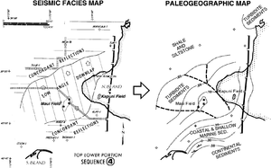
Figure 1 Seismic facies map and corresponding paleogeographic map of the Middle Miocene Taranaki basin, offshore western New Zealand. From Bally;[1] courtesy AAPG.
Figure 1 is a seismic facies map and the corresponding paleogeographic map of the Middle Miocene Taranaki basin, offshore western New Zealand. The paleogeographic map depicts lithofacies and thicknesses in two-way time.
See also
- Basin-fill and trap analysis
- Procedure for basin-fill analysis
- Mapping unconformities
- Analyzing depositional sequences for traps
References
- ↑ Bally, A. W., ed., 1987, Atlas of Seismic Stratigraphy: AAPG Studies in Geology 27, vol. 1, 124 p.
External links
| find literature about Mapping paleogeography |