Difference between revisions of "Sorrento field: water saturation"
Cwhitehurst (talk | contribs) |
Cwhitehurst (talk | contribs) m (added Category:Treatise Handbook 3 using HotCat) |
||
| (5 intermediate revisions by 2 users not shown) | |||
| Line 6: | Line 6: | ||
| part = Predicting the occurrence of oil and gas traps | | part = Predicting the occurrence of oil and gas traps | ||
| chapter = Predicting reservoir system quality and performance | | chapter = Predicting reservoir system quality and performance | ||
| − | | frompg = 9- | + | | frompg = 9-135 |
| − | | topg = 9- | + | | topg = 9-136 |
| author = Dan J. Hartmann, Edward A. Beaumont | | author = Dan J. Hartmann, Edward A. Beaumont | ||
| link = http://archives.datapages.com/data/specpubs/beaumont/ch09/ch09.htm | | link = http://archives.datapages.com/data/specpubs/beaumont/ch09/ch09.htm | ||
| Line 17: | Line 17: | ||
The Sorrento field is in Cheyenne County, southeastern Colorado on the north flank of the Las Animas arch. This case study is a summary of a larger study by Hartmann and Coalson.<ref name=Hartmannandcoalson_1990>Hartmann, D. J., and E. B. Coalson, 1990, Evaluation of the Morrow Sandstone in Sorrento field, Cheyenne County, Colorado, ''in'' S. A. Sonnenberg, L. T. Shannon, K. Rader, W. F. von Drehle, and G. W. Martin, eds., Morrow sandstones of Southeast Colorado and Adjacent Areas: Rocky Mountain Association of Geologists Symposium, p. 91-100.</ref> This study of cores and logs from four field wells shows how multiple oil–water contacts and apparent anomalies in saturation profiles in the Sorrento field are due to multiple flow units from two separate reservoirs. This example useful for finding other traps in the same formation. | The Sorrento field is in Cheyenne County, southeastern Colorado on the north flank of the Las Animas arch. This case study is a summary of a larger study by Hartmann and Coalson.<ref name=Hartmannandcoalson_1990>Hartmann, D. J., and E. B. Coalson, 1990, Evaluation of the Morrow Sandstone in Sorrento field, Cheyenne County, Colorado, ''in'' S. A. Sonnenberg, L. T. Shannon, K. Rader, W. F. von Drehle, and G. W. Martin, eds., Morrow sandstones of Southeast Colorado and Adjacent Areas: Rocky Mountain Association of Geologists Symposium, p. 91-100.</ref> This study of cores and logs from four field wells shows how multiple oil–water contacts and apparent anomalies in saturation profiles in the Sorrento field are due to multiple flow units from two separate reservoirs. This example useful for finding other traps in the same formation. | ||
| − | [[Morrow]] | + | [[Morrow sandstone]] [[reservoir]]s display multiple [http://www.glossary.oilfield.slb.com/en/Terms.aspx?LookIn=term%20name&filter=oil-water%20contact oil-water] contacts in several fields in the area <ref name=Sonnenbergetal_1991>Sonnenberg, S. A., D. J. McKenna, and P. J. McKenna, 1991, Sorrento field—U.S.A. Denver Basin, Colorado, "in" N. H. Foster and E. A. Beaumont, eds., Stratigraphic traps II: AAPG Treatise of Petroleum Geology, Atlas of Oil and Gas Fields, p. 305–328.</ref> Reliably recognizing separate reservoirs in a field requires considering [[capillary pressure]]s, [[Free water level|heights above free water]], and observed [[water saturation]]s. One convenient way to do this is to plot water saturation (S<sub>w</sub>) against structural elevation while differentiating [[Pore and pore throat sizes|pore throat sizes]]. |
==S<sub>w</sub>-elevation plot== | ==S<sub>w</sub>-elevation plot== | ||
An S<sub>w</sub>-elevation plot ([[:file:predicting-reservoir-system-quality-and-performance_fig9-95.png|Figure 1]]) for study wells 4, 8, and 11 defines a trend of decreasing [[water saturation]] with increasing height. Well 1 is not on the same trend. Differences in water saturation attributable to differences in [[capillary pressure]]s are apparent but are not great enough to explain the discrepancy. Ignoring possible hydrodynamic effects, the difference in trends probably represents two separate oil columns and therefore two reservoirs. | An S<sub>w</sub>-elevation plot ([[:file:predicting-reservoir-system-quality-and-performance_fig9-95.png|Figure 1]]) for study wells 4, 8, and 11 defines a trend of decreasing [[water saturation]] with increasing height. Well 1 is not on the same trend. Differences in water saturation attributable to differences in [[capillary pressure]]s are apparent but are not great enough to explain the discrepancy. Ignoring possible hydrodynamic effects, the difference in trends probably represents two separate oil columns and therefore two reservoirs. | ||
| − | [[file:predicting-reservoir-system-quality-and-performance_fig9-95.png|left|400px|thumb|{{figure number|1}}From Hartmann and Coalson.<ref name=Hartmannandcoalson_1990>Hartmann, D. J., and E. B. Coalson, 1990, Evaluation of the Morrow sandstone in Sorrento field, Cheyenne County, Colorado, ''in'' S. A. Sonnenberg, L. T. Shannon, K. Rader, W. F. von Drehle, and G.W. Martin, eds., Morrow Sandstones of Southeast Colorado and Adjacent Areas: RMAG Symposium, p. 91-100.</ref> Courtesy Rocky Mountain Association of Geologists.]] | + | [[file:predicting-reservoir-system-quality-and-performance_fig9-95.png|left|400px|thumb|{{figure number|1}}An S<sub>w</sub>-elevation plot. From Hartmann and Coalson.<ref name=Hartmannandcoalson_1990>Hartmann, D. J., and E. B. Coalson, 1990, Evaluation of the Morrow sandstone in Sorrento field, Cheyenne County, Colorado, ''in'' S. A. Sonnenberg, L. T. Shannon, K. Rader, W. F. von Drehle, and G.W. Martin, eds., Morrow Sandstones of Southeast Colorado and Adjacent Areas: RMAG Symposium, p. 91-100.</ref> Courtesy Rocky Mountain Association of Geologists.]] |
{{clear}} | {{clear}} | ||
| + | |||
| + | ==Method== | ||
| + | |||
| + | [[Basic_open_hole_tools#Density|Density logs]] were the primary source of [[porosity]] values. Matrix density appears to be about 2.68 g/cc, based on core-measured grain densities (consistent with the presumed mineralogy of the sandstones). Crosspiot porosities were not used to avoid introducing a systematic error in these variably shaly sandstones.<ref name=ch09r42>Patchett, J., G., Coalson, E., B., 1982, The determination of porosity in sandstone and shaly sandstone, part 2: effects of complex mineralogy and hydrocarbons: 23rd Annual SPWLA Logging Symposium, July 6–9, paper T, 50 p.</ref> | ||
| + | |||
| + | ==Pickett plot== | ||
| + | <gallery mode=packed heights=300px widths=300px> | ||
| + | predicting-reservoir-system-quality-and-performance_fig9-89.png|{{figure number|1}}Data from well 11. From Hartmann and Coalson.<ref name=Hartmannandcoalson_1990>Hartmann, D. J., and E. B. Coalson, 1990, Evaluation of the Morrow sandstone in Sorrento field, Cheyenne County, Colorado, ''in'' S. A. Sonnenberg, L. T. Shannon, K. Rader, W. F. von Drehle, and G.W. Martin, eds., Morrow Sandstones of Southeast Colorado and Adjacent Areas: RMAG Symposium, p. 91-100.</ref> Courtesy Rocky Mountain Association of Geologists. | ||
| + | predicting-reservoir-system-quality-and-performance_fig9-88.png|{{figure number|2}}Capillary pressure curve. From Hartmann and Coalson.<ref name=Hartmannandcoalson_1990 /> Courtesy Rocky Mountain Association of Geologists. | ||
| + | </gallery> | ||
| + | |||
| + | Formation-water resistivities and water saturations were estimated from Pickett plots (see [[Pickett plot construction]]). The inferred cementation exponent ''(m)'' is 1.8 because of the presence of clays, well-connected solution pores (e.g., <ref name=ch09r31>James, S., W., 1989, Diagenetic history and reservoir characteristics of a deep Minnelusa reservoir, Hawk Point field, Powder River basin, Wyoming, ''in'' Coalson, E., B., Kaplan, S., S., Keighin, C., W., Oglesby, C., A., Robinson, J., W., eds., Petrogenesis and Petrophysics of Selected Sandstone Reservoirs of the Rocky Mountain Region: Rocky Mountain Association of Geologists Symposium, p. 81–96.</ref>, <ref name=ch09r39>Muller, M., M., Coalson, E., B., 1989, Diagenetic and petrophysical variations of the Dakota sandstone, Henry field, Green River basin, Wyoming, ''in'' Coalson, E., B., Kaplan, S., S., Keighin, C., W., Oglesby, C., A., Robinson, J., W., eds., Petrogenesis and Petrophysics of Selected Sandstone Reservoirs of the Rocky Mountain Region: Rocky Mountain Association of Geologists Symposium, p. 149–158.</ref>, or [[Wikipedia:Pyrite|pyrite]] [Kristinick, personal communication]). Formation factors measured on core samples from well 1 support this interpretation. | ||
| + | |||
| + | The Pickett plot in [[:file:predicting-reservoir-system-quality-and-performance_fig9-89.png|Figure 1]] shows data from well 11. The number labels represent the flow units from [[:file:predicting-reservoir-system-quality-and-performance_fig9-88.png|Figure 2]]. | ||
| + | |||
| + | ==Saturation exponents, ''n''== | ||
| + | Saturation exponents ''(n)'' measured on samples from well 1 showed variations that relate to pore geometry. Microporous siltstones displayed ''n'' greater than 2, indicating either very tortuous pore systems or incomplete saturation by brine during testing. Saturation exponents were less than 2 in the best porosity type. This implies the reservoir is somewhat shaly. However, ''n'' was assumed equal to 2 for log calculations because the lab data were not far from that value and because lab measurements of saturation exponents are notoriously difficult. | ||
==See also== | ==See also== | ||
| Line 42: | Line 59: | ||
[[Category:Predicting the occurrence of oil and gas traps]] | [[Category:Predicting the occurrence of oil and gas traps]] | ||
[[Category:Predicting reservoir system quality and performance]] | [[Category:Predicting reservoir system quality and performance]] | ||
| + | [[Category:Treatise Handbook 3]] | ||
Latest revision as of 16:57, 13 April 2022
| Exploring for Oil and Gas Traps | |

| |
| Series | Treatise in Petroleum Geology |
|---|---|
| Part | Predicting the occurrence of oil and gas traps |
| Chapter | Predicting reservoir system quality and performance |
| Author | Dan J. Hartmann, Edward A. Beaumont |
| Link | Web page |
| Store | AAPG Store |
The Sorrento field is in Cheyenne County, southeastern Colorado on the north flank of the Las Animas arch. This case study is a summary of a larger study by Hartmann and Coalson.[1] This study of cores and logs from four field wells shows how multiple oil–water contacts and apparent anomalies in saturation profiles in the Sorrento field are due to multiple flow units from two separate reservoirs. This example useful for finding other traps in the same formation.
Morrow sandstone reservoirs display multiple oil-water contacts in several fields in the area [2] Reliably recognizing separate reservoirs in a field requires considering capillary pressures, heights above free water, and observed water saturations. One convenient way to do this is to plot water saturation (Sw) against structural elevation while differentiating pore throat sizes.
Sw-elevation plot
An Sw-elevation plot (Figure 1) for study wells 4, 8, and 11 defines a trend of decreasing water saturation with increasing height. Well 1 is not on the same trend. Differences in water saturation attributable to differences in capillary pressures are apparent but are not great enough to explain the discrepancy. Ignoring possible hydrodynamic effects, the difference in trends probably represents two separate oil columns and therefore two reservoirs.

Method
Density logs were the primary source of porosity values. Matrix density appears to be about 2.68 g/cc, based on core-measured grain densities (consistent with the presumed mineralogy of the sandstones). Crosspiot porosities were not used to avoid introducing a systematic error in these variably shaly sandstones.[3]
Pickett plot
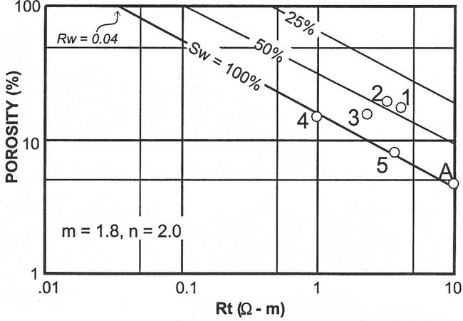
Figure 1 Data from well 11. From Hartmann and Coalson.[1] Courtesy Rocky Mountain Association of Geologists.
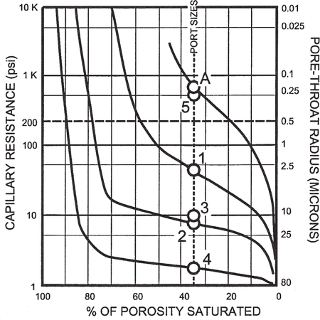
Figure 2 Capillary pressure curve. From Hartmann and Coalson.[1] Courtesy Rocky Mountain Association of Geologists.


Formation-water resistivities and water saturations were estimated from Pickett plots (see Pickett plot construction). The inferred cementation exponent (m) is 1.8 because of the presence of clays, well-connected solution pores (e.g., [4], [5], or pyrite [Kristinick, personal communication]). Formation factors measured on core samples from well 1 support this interpretation.
The Pickett plot in Figure 1 shows data from well 11. The number labels represent the flow units from Figure 2.
Saturation exponents, n
Saturation exponents (n) measured on samples from well 1 showed variations that relate to pore geometry. Microporous siltstones displayed n greater than 2, indicating either very tortuous pore systems or incomplete saturation by brine during testing. Saturation exponents were less than 2 in the best porosity type. This implies the reservoir is somewhat shaly. However, n was assumed equal to 2 for log calculations because the lab data were not far from that value and because lab measurements of saturation exponents are notoriously difficult.
See also
- Setting and structure of the Sorrento field
- Morrow lithofacies and pore types
- Sorrento water saturation calculations
- Petrophysical analysis of Sorrento field wells
References
- ↑ 1.0 1.1 1.2 1.3 Hartmann, D. J., and E. B. Coalson, 1990, Evaluation of the Morrow Sandstone in Sorrento field, Cheyenne County, Colorado, in S. A. Sonnenberg, L. T. Shannon, K. Rader, W. F. von Drehle, and G. W. Martin, eds., Morrow sandstones of Southeast Colorado and Adjacent Areas: Rocky Mountain Association of Geologists Symposium, p. 91-100. Cite error: Invalid
<ref>tag; name "Hartmannandcoalson_1990" defined multiple times with different content Cite error: Invalid<ref>tag; name "Hartmannandcoalson_1990" defined multiple times with different content - ↑ Sonnenberg, S. A., D. J. McKenna, and P. J. McKenna, 1991, Sorrento field—U.S.A. Denver Basin, Colorado, "in" N. H. Foster and E. A. Beaumont, eds., Stratigraphic traps II: AAPG Treatise of Petroleum Geology, Atlas of Oil and Gas Fields, p. 305–328.
- ↑ Patchett, J., G., Coalson, E., B., 1982, The determination of porosity in sandstone and shaly sandstone, part 2: effects of complex mineralogy and hydrocarbons: 23rd Annual SPWLA Logging Symposium, July 6–9, paper T, 50 p.
- ↑ James, S., W., 1989, Diagenetic history and reservoir characteristics of a deep Minnelusa reservoir, Hawk Point field, Powder River basin, Wyoming, in Coalson, E., B., Kaplan, S., S., Keighin, C., W., Oglesby, C., A., Robinson, J., W., eds., Petrogenesis and Petrophysics of Selected Sandstone Reservoirs of the Rocky Mountain Region: Rocky Mountain Association of Geologists Symposium, p. 81–96.
- ↑ Muller, M., M., Coalson, E., B., 1989, Diagenetic and petrophysical variations of the Dakota sandstone, Henry field, Green River basin, Wyoming, in Coalson, E., B., Kaplan, S., S., Keighin, C., W., Oglesby, C., A., Robinson, J., W., eds., Petrogenesis and Petrophysics of Selected Sandstone Reservoirs of the Rocky Mountain Region: Rocky Mountain Association of Geologists Symposium, p. 149–158.
External links
| find literature about Sorrento field: water saturation |