Search results
Jump to navigation
Jump to search
Page title matches
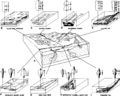
- As it arrives on tape from the [[Basic seismic processing|processor]], 3-D [[seismic data]] are organized into lines composed of [[trace]]s. In the co ...tal slices. From Liner.<ref name=Liner_1999>Liner, C., 1999. Elements of 3-D Seismology: Tulsa, PennWell.</ref> Courtesy PennWell.]]3 KB (373 words) - 19:06, 27 January 2022
- #REDIRECT [[3-D seismic data: the data cube]]45 bytes (7 words) - 14:11, 28 May 2014
- #REDIRECT [[Talk:3-D seismic data: the data cube]]50 bytes (8 words) - 14:11, 28 May 2014
- 137 bytes (17 words) - 15:57, 22 October 2014
- 90 bytes (13 words) - 16:02, 22 October 2014
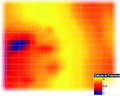
- | chapter = Interpreting 3-D seismic data ...displays. With each additional visual cue used in presenting the data in 3-D, there have been improvements in efficiency. New insights have been gained4 KB (601 words) - 19:49, 27 January 2022
- | chapter = Interpreting 3-D seismic data ...opicker works. © Dorn.<ref name=Dorn_1998>Dorn, G. A., 1998, Modern 3-D seismic interpretation: The Leading Edge, v. 17, no. 9, p. 1262-1272.</ref>8 KB (1,155 words) - 19:12, 27 January 2022

File:Interpreting-3-d-seismic-data fig13-12.png (1,200 × 949 (1.12 MB)) - 20:53, 17 January 2014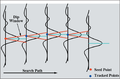
File:Interpreting-3-d-seismic-data fig13-5.png (1,124 × 743 (177 KB)) - 20:42, 17 January 2014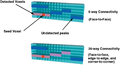
File:Interpreting-3-d-seismic-data fig13-6.png (1,601 × 869 (400 KB)) - 20:43, 17 January 2014
File:Interpreting-3-d-seismic-data fig13-7.png (1,687 × 542 (499 KB)) - 20:45, 17 January 2014
File:Interpreting-3-d-seismic-data fig13-8.png (1,669 × 977 (1,006 KB)) - 20:46, 17 January 2014- #REDIRECT [[3-D seismic data: proportional slices and volume visualization]]76 bytes (9 words) - 21:31, 22 January 2015
File:Interpreting-3-d-seismic-data fig13-9.png (1,652 × 876 (1.37 MB)) - 20:49, 17 January 2014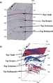
File:Interpreting-3-d-seismic-data fig13-1.png (1,276 × 2,005 (1.5 MB)) - 20:35, 17 January 2014
File:Interpreting-3-d-seismic-data fig13-10.png (1,213 × 1,057 (870 KB)) - 20:50, 17 January 2014
File:Interpreting-3-d-seismic-data fig13-2.png (1,682 × 1,119 (1.48 MB)) - 20:39, 17 January 2014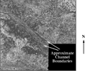
File:Interpreting-3-d-seismic-data fig13-11.png (1,203 × 1,016 (739 KB)) - 20:51, 17 January 2014- #REDIRECT [[3-D seismic data: time and horizon slices]]55 bytes (8 words) - 14:29, 19 December 2014
File:Interpreting-3-d-seismic-data fig13-3.png (1,495 × 932 (1.88 MB)) - 20:40, 17 January 2014- 39 bytes (4 words) - 15:21, 19 December 2014
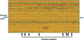
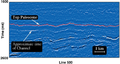
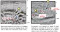
File:Interpreting-3-d-seismic-data fig13-4.png (1,672 × 809 (1.04 MB)) - 20:41, 17 January 2014- | chapter = Interpreting 3-D seismic data The time slice is the first step toward 3-D interpretation of a 3-D seismic volume. A time-slice view of the data is an improvement over vertic4 KB (617 words) - 19:30, 27 January 2022
- #REDIRECT [[3-D seismic data: proportional slices and volume visualization]]76 bytes (9 words) - 14:29, 19 December 2014
- | chapter = Interpreting 3-D seismic data Additional refinement to the [[3-D seismic: time and horizon slices|horizon-slice]] approach can be made to ac3 KB (457 words) - 19:32, 27 January 2022
- 138 bytes (23 words) - 14:11, 28 May 2014
- ...mic technique yields much more information than an equivalent amount of 2-D seismic and can reduce [[Reducing exploration risk|risk]]. ==3-D advantages==5 KB (813 words) - 19:05, 27 January 2022


Page text matches
File:Three-dimensional-seismic-method fig1.png ...a marine 3-D survey. (b) The corresponding 2-D migrated section. (c) The 3-D migrated section. (Data courtesy of Amoco Europe and West Africa, Inc}} ...a marine 3-D survey. (b) The corresponding 2-D migrated section. (c) The 3-D migrated section. (Data courtesy of Amoco Europe and West Africa, Inc.(943 × 2,518 (143 KB)) - 19:36, 14 January 2014
File:M31F16.jpg .... Prior, 1981, Deltaic environments of deposition ''in'' P. A. Scholle and D. Spearing, eds., Sandstone depositional environments: AAPG Memoir 31, p. 13(356 × 353 (54 KB)) - 18:14, 18 August 2014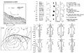
File:M31F26.jpg .... Prior, 1981, Deltaic environments of deposition ''in'' P. A. Scholle and D. Spearing, eds., Sandstone depositional environments: AAPG Memoir 31, p. 13(1,499 × 968 (531 KB)) - 18:22, 18 August 2014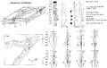
File:M31F13.jpg ...D. B. Prior, 1981, Deltaic environments of deposition in P. A. Scholle and D. Spearing, eds., Sandstone depositional environments: AAPG Memoir 31, p. 13(1,508 × 950 (293 KB)) - 15:16, 18 August 2014
File:M31F9.jpg ...D. B. Prior, 1981, Deltaic environments of deposition in P. A. Scholle and D. Spearing, eds., Sandstone depositional environments: AAPG Memoir 31, p. 13(1,510 × 990 (305 KB)) - 15:13, 18 August 2014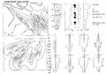
File:M31F22.jpg .... Prior, 1981, Deltaic environments of deposition ''in'' P. A. Scholle and D. Spearing, eds., Sandstone depositional environments: AAPG Memoir 31, p. 13(1,416 × 989 (554 KB)) - 18:20, 18 August 2014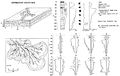
File:M31F17.jpg .... Prior, 1981, Deltaic environments of deposition ''in'' P. A. Scholle and D. Spearing, eds., Sandstone depositional environments: AAPG Memoir 31, p. 13(1,519 × 957 (150 KB)) - 18:17, 18 August 2014
File:M31F29.jpg .... Prior, 1981, Deltaic environments of deposition ''in'' P. A. Scholle and D. Spearing, eds., Sandstone depositional environments: AAPG Memoir 31, p. 13(1,161 × 1,502 (970 KB)) - 18:25, 18 August 2014
File:M31F15.jpg ...D. B. Prior, 1981, Deltaic environments of deposition in P. A. Scholle and D. Spearing, eds., Sandstone depositional environments: AAPG Memoir 31, p. 13(1,194 × 1,001 (1.91 MB)) - 15:17, 18 August 2014
File:M31F23.jpg .... Prior, 1981, Deltaic environments of deposition ''in'' P. A. Scholle and D. Spearing, eds., Sandstone depositional environments: AAPG Memoir 31, p. 13(1,476 × 791 (905 KB)) - 18:20, 18 August 2014
File:M31F8.jpg ...D. B. Prior, 1981, Deltaic environments of deposition in P. A. Scholle and D. Spearing, eds., Sandstone depositional environments: AAPG Memoir 31, p. 13(744 × 752 (412 KB)) - 15:12, 18 August 2014
File:Three-dimensional-seismic-method fig2.png ...survey and (b) a time-structure map of a marker horizon derived from the 3-D volume of migrated data. (Data courtesy of Western Geophysical, Division of ...survey and (b) a time-structure map of a marker horizon derived from the 3-D volume of migrated data. (Data courtesy of Western Geophysical, Division of(1,338 × 2,684 (369 KB)) - 19:36, 14 January 2014
File:M31F11.jpg ...D. B. Prior, 1981, Deltaic environments of deposition in P. A. Scholle and D. Spearing, eds., Sandstone depositional environments: AAPG Memoir 31, p. 13(951 × 1,393 (675 KB)) - 15:15, 18 August 2014
File:M31F19.jpg .... Prior, 1981, Deltaic environments of deposition ''in'' P. A. Scholle and D. Spearing, eds., Sandstone depositional environments: AAPG Memoir 31, p. 13(1,343 × 1,017 (615 KB)) - 18:17, 18 August 2014
File:M31F12.jpg ...D. B. Prior, 1981, Deltaic environments of deposition in P. A. Scholle and D. Spearing, eds., Sandstone depositional environments: AAPG Memoir 31, p. 13(946 × 1,383 (664 KB)) - 15:15, 18 August 2014- ...specpubs/methodo1/data/a095/a095/0001/0200/0221.htm Capillary pressure] in D. Morton-Thompson and A. M. Woods, eds., Development Geology Reference Manua557 bytes (82 words) - 14:13, 24 July 2014
File:M31F20.jpg .... Prior, 1981, Deltaic environments of deposition ''in'' P. A. Scholle and D. Spearing, eds., Sandstone depositional environments: AAPG Memoir 31, p. 13(1,158 × 1,014 (1.94 MB)) - 18:18, 18 August 2014
File:M31F21.jpg .... Prior, 1981, Deltaic environments of deposition ''in'' P. A. Scholle and D. Spearing, eds., Sandstone depositional environments: AAPG Memoir 31, p. 13(1,120 × 1,026 (1.69 MB)) - 18:19, 18 August 2014- #REDIRECT [[3-D seismic data: immersive visualization]]55 bytes (6 words) - 15:56, 22 October 2014
File:Evaluating-source-rocks fig6-15.png {{copyright|results of Genex 1-D basin modeling software, courtesy Institute Français du Petrole}} . Copyright: results of Genex 1-D basin modeling software, courtesy Institute Français du Petrole.(1,715 × 799 (298 KB)) - 13:54, 24 January 2014
File:Evaluating-source-rocks fig6-17.png {{copyright|results of Genex 1-D basin modeling software, courtesy Institute Français du Petrole}} . Copyright: results of Genex 1-D basin modeling software, courtesy Institute Français du Petrole.(1,704 × 858 (181 KB)) - 13:56, 24 January 2014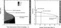
File:Evaluating-source-rocks fig6-18.png {{copyright|results of Genex 1-D basin modeling software, courtesy Institute Français du Petrole}} . Copyright: results of Genex 1-D basin modeling software, courtesy Institute Français du Petrole.(1,684 × 773 (111 KB)) - 13:58, 24 January 2014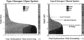
File:Evaluating-source-rocks fig6-19.png {{copyright|results of Genex 1-D basin modeling software, courtesy Institute Français du Petrole}} . Copyright: results of Genex 1-D basin modeling software, courtesy Institute Français du Petrole.(1,604 × 781 (289 KB)) - 13:59, 24 January 2014
File:M31F27.jpg .... Prior, 1981, Deltaic environments of deposition ''in'' P. A. Scholle and D. Spearing, eds., Sandstone depositional environments: AAPG Memoir 31, p. 13(760 × 1,372 (583 KB)) - 18:23, 18 August 2014- #REDIRECT [[3-D seismic data: time and horizon slices]]55 bytes (8 words) - 14:29, 19 December 2014
- #REDIRECT [[3-D seismic data: time and horizon slices]]55 bytes (8 words) - 16:25, 26 January 2015

File:MainPageDeltaPlainUpper.jpg Photo by [https://commons.wikimedia.org/wiki/User:Pablo-flores Pablo D. Flores](800 × 800 (205 KB)) - 15:52, 29 June 2015
File:M31F28.jpg .... Prior, 1981, Deltaic environments of deposition ''in'' P. A. Scholle and D. Spearing, eds., Sandstone depositional environments: AAPG Memoir 31, p. 13(1,230 × 1,012 (1.84 MB)) - 18:24, 18 August 2014- #REDIRECT [[3-D seismic data: proportional slices and volume visualization]]76 bytes (9 words) - 14:29, 19 December 2014
- #REDIRECT [[3-D seismic data: proportional slices and volume visualization]]76 bytes (9 words) - 21:31, 22 January 2015
File:M31F14v2.jpg ...D. B. Prior, 1981, Deltaic environments of deposition in P. A. Scholle and D. Spearing, eds., Sandstone depositional environments: AAPG Memoir 31, p. 13(1,134 × 503 (75 KB)) - 15:16, 18 August 2014
File:M31F5.jpg ...posits. From Deltaic environments of deposition, 1981, Coleman, J. M., and D. B. Prior, in AAPG Memoir 31.(1,152 × 941 (941 KB)) - 19:33, 15 August 2014- *C D *D438 bytes (74 words) - 18:00, 15 October 2014
File:M31F24.jpg .... Prior, 1981, Deltaic environments of deposition ''in'' P. A. Scholle and D. Spearing, eds., Sandstone depositional environments: AAPG Memoir 31, p. 13(758 × 947 (524 KB)) - 18:21, 18 August 2014- :<math>w = \frac{R g D^2}{C_1 \nu + \sqrt{0.75\,C_2\, R g D^3}}</math> :<math>w = \frac{R g D^2}{C_1 \nu + \sqrt{0.75\,C_2\, R g D^3}}</math>1 KB (207 words) - 16:45, 9 October 2013
- #REDIRECT [[Talk:3-D seismic data: the data cube]]50 bytes (8 words) - 14:11, 28 May 2014
- #REDIRECT [[3-D seismic data: the data cube]]45 bytes (7 words) - 14:11, 28 May 2014
- ...77/m77ch24/m77ch24.htm Eogenetic meteoric diagenesis] in P. A. Scholle and D. Ulmer-Scholle, A color guide to the petrography of carbonate rocks: Grains648 bytes (87 words) - 15:34, 10 December 2015
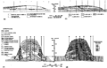
File:ST53 Part01 Pg11A.jpg ...-Related Folds, An AAPG Seismic Atlas, edited by John H. Shaw, Christopher D. Connors and John Suppe, 2005. Pages 1-59.(750 × 509 (230 KB)) - 16:23, 28 July 2015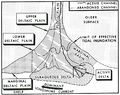
File:M31F1.jpg ...system. From Deltaic environments of deposition, 1981, Coleman, J. M., and D. B. Prior, in AAPG Memoir 31.(744 × 591 (256 KB)) - 18:15, 15 August 2014- | chapter = Interpreting 3-D seismic data The time slice is the first step toward 3-D interpretation of a 3-D seismic volume. A time-slice view of the data is an improvement over vertic4 KB (617 words) - 19:30, 27 January 2022
File:Seismic-inversion fig4.png {{copyright|the Taber area of southern Alberta. The 3-D survey was done in the area outlined by the rectangle in the center of the ...a river channel zone. Copyright: the Taber area of southern Alberta. The 3-D survey was done in the area outlined by the rectangle in the center of the(841 × 461 (31 KB)) - 19:34, 14 January 2014
File:M31F4.jpg ...posits. From Deltaic environments of deposition, 1981, Coleman, J. M., and D. B. Prior, in AAPG Memoir 31.(1,464 × 916 (326 KB)) - 19:19, 15 August 2014- | chapter = Interpreting 3-D seismic data Additional refinement to the [[3-D seismic: time and horizon slices|horizon-slice]] approach can be made to ac3 KB (457 words) - 19:32, 27 January 2022
File:Checkshots-and-vertical-seismic-profiles fig4.png ...the source-receiver positions involved in (a and b) zero offset and (c and d) offset VSP recording geometries.(942 × 1,445 (56 KB)) - 21:29, 13 January 2014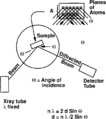
File:Sem-xrd-cl-and-xf-methods fig2.png ...ation. Knowledge of the wavelength (X) and angle of incidence allows the ''d'' spacing to be calculated.(933 × 1,051 (19 KB)) - 22:29, 14 January 2014- ...ture is small compared with fracture length.<ref name=ch02r10>Pollard, D., D., Segall, P., 1987, Theoretical displacements add stresses near fractures w951 bytes (136 words) - 20:39, 10 February 2015
- ...mic technique yields much more information than an equivalent amount of 2-D seismic and can reduce [[Reducing exploration risk|risk]]. ==3-D advantages==5 KB (813 words) - 19:05, 27 January 2022
File:ST53 Part01 Pg07.jpg ...-Related Folds, An AAPG Seismic Atlas, edited by John H. Shaw, Christopher D. Connors and John Suppe, 2005. Pages 1-59.(750 × 1,637 (452 KB)) - 17:26, 21 July 2015
File:ST53 Part01 Pg03A.jpg ...-Related Folds, An AAPG Seismic Atlas, edited by John H. Shaw, Christopher D. Connors and John Suppe, 2005. Pages 1-59.(750 × 703 (127 KB)) - 17:01, 21 July 2015
File:ST53 Part01 Pg03B.jpg ...-Related Folds, An AAPG Seismic Atlas, edited by John H. Shaw, Christopher D. Connors and John Suppe, 2005. Pages 1-59.(750 × 792 (159 KB)) - 17:04, 21 July 2015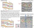
File:ST53 Part01 Pg05A.jpg ...-Related Folds, An AAPG Seismic Atlas, edited by John H. Shaw, Christopher D. Connors and John Suppe, 2005. Pages 1-59.(750 × 607 (201 KB)) - 17:13, 21 July 2015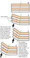
File:ST53 Part01 Pg05B.jpg ...-Related Folds, An AAPG Seismic Atlas, edited by John H. Shaw, Christopher D. Connors and John Suppe, 2005. Pages 1-59.(750 × 1,465 (176 KB)) - 17:14, 21 July 2015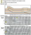
File:ST53 Part01 Pg06A.jpg ...-Related Folds, An AAPG Seismic Atlas, edited by John H. Shaw, Christopher D. Connors and John Suppe, 2005. Pages 1-59.(750 × 846 (233 KB)) - 17:22, 21 July 2015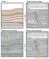
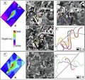
File:ST53 Part01 Pg06B.jpg ...-Related Folds, An AAPG Seismic Atlas, edited by John H. Shaw, Christopher D. Connors and John Suppe, 2005. Pages 1-59.(750 × 891 (261 KB)) - 17:24, 21 July 2015- ...ally requires computer assistance for [[Three-dimensional seismic method|3-D data]]. The recipes described on the pages that follow apply to hand or com | Migrated Depth || Mapping an area using a 3-D seismic data cube with the vertical axis converted to depth (commonly used2 KB (320 words) - 19:10, 27 January 2022
File:M31F10v2.jpg ...D. B. Prior, 1981, Deltaic environments of deposition in P. A. Scholle and D. Spearing, eds., Sandstone depositional environments: AAPG Memoir 31, p. 13(1,334 × 1,000 (178 KB)) - 15:14, 18 August 2014
File:M31F6.jpg ...plain. From Deltaic environments of deposition, 1981, Coleman, J. M., and D. B. Prior, in AAPG Memoir 31.(1,467 × 1,013 (318 KB)) - 19:40, 15 August 2014
File:Subsurface-maps fig7.png Cumulative oil production map for the A, B, C, and D zones from the San Andres Formation reservoir, Jordan field, Ector and Cran(944 × 1,353 (62 KB)) - 20:42, 14 January 2014
File:M31F3.jpg ...raphs). From Deltaic environments of deposition, 1981, Coleman, J. M., and D. B. Prior, in AAPG Memoir 31.(2,941 × 1,884 (830 KB)) - 19:02, 15 August 2014- ...d in maintaining this wiki, please [mailto:[email protected] get in touch!] We'd love to hear from you.2 KB (218 words) - 15:55, 2 April 2014
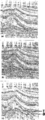
- | chapter = Interpreting 3-D seismic data ...in each slab only the peaks are displayed. The dissected portions of the 3-D structure appear as annuli that fit perfectly within each other. Interpreti4 KB (553 words) - 19:30, 27 January 2022
File:ST53 Part01 Pg08D.jpg ...-Related Folds, An AAPG Seismic Atlas, edited by John H. Shaw, Christopher D. Connors and John Suppe, 2005. Pages 1-59.(750 × 405 (164 KB)) - 20:39, 27 July 2015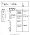
File:M91Ch6FG42.JPG Example of a sedimentological core log, Well d-2-C/94a-16, Peejay field, Canada (after Caplan and Moslow, 1999). From Shep(800 × 942 (95 KB)) - 17:04, 3 June 2015
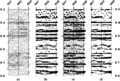
File:Seismic-inversion fig6.png Time slice displays through the 3-D survey of the river channel zone. The lightly shaded areas show low velocit(2,045 × 1,222 (1.56 MB)) - 19:34, 14 January 2014- ...d in maintaining this wiki, please [mailto:[email protected] get in touch!] We'd love to hear from you.2 KB (250 words) - 19:00, 31 March 2014
- ...d in maintaining this wiki, please [mailto:[email protected] get in touch!] We'd love to hear from you.2 KB (269 words) - 19:34, 31 March 2014
File:ST53Part01Pg13.jpg ...-Related Folds, An AAPG Seismic Atlas, edited by John H. Shaw, Christopher D. Connors and John Suppe, 2005. Pages 1-59.(750 × 462 (163 KB)) - 20:31, 28 July 2015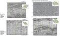
File:ST53 Part01 Pg04.jpg ...-Related Folds, An AAPG Seismic Atlas, edited by John H. Shaw, Christopher D. Connors and John Suppe, 2005. Pages 1-59.(750 × 454 (169 KB)) - 17:10, 21 July 2015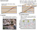
File:ST53 Part01 Pg08B.jpg ...-Related Folds, An AAPG Seismic Atlas, edited by John H. Shaw, Christopher D. Connors and John Suppe, 2005. Pages 1-59.(750 × 607 (183 KB)) - 17:58, 21 July 2015
File:M31F18.jpg .... Prior, 1981, Deltaic environments of deposition ''in'' P. A. Scholle and D. Spearing, eds., Sandstone depositional environments: AAPG Memoir 31, p. 13(1,349 × 994 (1.86 MB)) - 18:16, 18 August 2014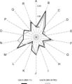
File:Mth14ch02f08.jpg ...s, Inc., written communication, 1998). From M. S. Clark, R. K. Prather, J. D. Melvin, 2003, Characterization and Exploitation of the Distal Margin of a(400 × 465 (28 KB)) - 20:19, 4 December 2015
File:ST53 Part01 Pg08C.jpg ...-Related Folds, An AAPG Seismic Atlas, edited by John H. Shaw, Christopher D. Connors and John Suppe, 2005. Pages 1-59.(750 × 258 (107 KB)) - 18:02, 21 July 2015- ...uate imaging of the subsurface resulting from the use of 2-D rather than 3-D migration<ref name=pt07r13>French, W. S., 1974, Two-dimensional and three-d ==Performing 3-D surveys==8 KB (1,201 words) - 20:24, 21 January 2022
File:M98Ch3Fig3.JPG ...the Cambrian–Ordovician great American carbonate bank, in J. R. Derby, R. D. Fritz, S. A. Longacre, W. A. Morgan, and C. A. Sternbach, eds., The great(600 × 743 (211 KB)) - 16:39, 19 August 2014- [[Category:Interpreting 3-D seismic data]]192 bytes (25 words) - 19:55, 14 April 2014
File:Displaying-seismic-data fig1.png ...(a) wiggle trace, (b) variable area, (c) variable area wiggle trace, and (d) variable density. Copyright: Conoco Inc.(1,959 × 1,316 (101 KB)) - 01:20, 14 January 2014- * Schelling, D. D., D. K. Strickland, K. R. Johnson, & J. P. Vrona, 2007, [http://archives.datapa ...Johnson, D. D. Schelling, D. A. Sprinkel, D. K. Strickland, J. P. Vrona, & D. A. Wavrek, 2007, [http://archives.datapages.com/data/uga/data/079/079001/24 KB (525 words) - 19:41, 14 February 2017
File:Drill-stem-testing fig7.png ...test. (A) running in hole; (B) initial flow period; (C) initial buildup; (D) final flow period; (E) final buildup; and (F) pulling out of hole.(728 × 559 (6 KB)) - 22:25, 14 January 2014- ...c models: one more complete and detail than the other one: 2-D, 3-D, and 4-D seismic. ====2-D Seismic====5 KB (708 words) - 22:00, 10 April 2019
File:M98Ch3Fig5.JPG ...als (alternating gray and white rectangles in the central column labeled B.D.I.) delineated through a combination of conodont and trilobite zonal or sub ...the Cambrian–Ordovician great American carbonate bank, in J. R. Derby, R. D. Fritz, S. A. Longacre, W. A. Morgan, and C. A. Sternbach, eds., The great(600 × 674 (275 KB)) - 16:53, 19 August 2014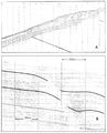
File:M31F25.jpg .... Prior, 1981, Deltaic environments of deposition ''in'' P. A. Scholle and D. Spearing, eds., Sandstone depositional environments: AAPG Memoir 31, p. 13(1,087 × 1,348 (940 KB)) - 18:21, 18 August 2014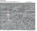
File:ST53Part01Pg14B.jpg ...-Related Folds, An AAPG Seismic Atlas, edited by John H. Shaw, Christopher D. Connors and John Suppe, 2005. Pages 1-59.(750 × 633 (197 KB)) - 20:48, 28 July 2015
File:Using-and-improving-surface-models-built-by-computer fig16.png ...ulted structure model built after removing vertical separation from data. (d) Faulted structure model built by subtracting separation model from unfault(933 × 1,056 (56 KB)) - 22:32, 13 January 2014
File:Conducting-a-reservoir-simulation-study-an-overview fig1.png ...dimensional tank. (b) One-dimensional linear. (c) One-dimensional radial. (d) Two-dimensional cross-sectional. (e) Two-dimensional area. (f) Two-dimensi(922 × 1,118 (50 KB)) - 18:46, 14 January 2014- | 3-D coherence ...ng-for-stratigraphic-traps_fig21-29.png|300px|thumb|{{figure number|1}}A 3-D coherency slice of a Miocene channel complex in the Nile Delta, Egypt. From4 KB (481 words) - 18:20, 4 February 2022
- ...ere. Keep them in mind when working with [[seismic data]]—in particular, 3-D seismic data. ...an onion. Copyright: Liner;<ref name=Liner>Liner, C., 1999, Elements of 3-D Seismology: Tulsa, PennWell.</ref> courtesy PennWell.]]5 KB (739 words) - 18:51, 27 January 2022
File:Drill-stem-testing fig3.png ...cushion/run in hole; (B) initial flow period; (C) initial shut-in period; (D) final flow period; (E) final shut-in period; and (F) pulling out of hole.(748 × 570 (5 KB)) - 22:25, 14 January 2014- | chapter = Interpreting 3-D seismic data ...ty and require significantly more effort than interpreting the data in a 3-D fashion.8 KB (1,280 words) - 17:33, 25 January 2022

File:Mudlogging-equipment-services-and-personnel fig1.png ...a. (A) Chromatograph. (B) Chromatograph chart. (C) Back-up chromatograph. (D) Depth and time monitoring equipment. (E) Power panel. (Photo. Copyright: L(1,013 × 1,483 (1.1 MB)) - 22:31, 14 January 2014- | chapter = Interpreting 3-D seismic data ...displays. With each additional visual cue used in presenting the data in 3-D, there have been improvements in efficiency. New insights have been gained4 KB (601 words) - 19:49, 27 January 2022
- ...ns will leak through the seal. If ''P''<sub>b</sub> is less than ''P''<sub>d</sub>, it would be possible to seal a greater column of hydrocarbons. :<math>P_{\rm b} = P_{\rm d}</math>3 KB (488 words) - 16:13, 31 March 2022
- {{fossil range/bar|Devonian|D}}1 KB (135 words) - 14:19, 5 November 2013
- ...n concept. Copyright: Liner,<ref name=Liner>Liner, C., 1999, Elements of 3-D Seimology: Tulsa, PennWell</ref> courtesy PennWell.]] ...ted into groups associated with one midpoint on the earth's surface. The 3-D seismic data are sorted into discrete areas called bins. All actual midpoin3 KB (426 words) - 19:05, 27 January 2022
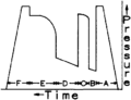
File:Drill-stem-testing fig6.png ...tic pressure of mud column; (B) initial flow period; (C) initial buildup; (D) final flow period; (E) final buildup; and (F) release packer and pulling o(724 × 556 (6 KB)) - 22:25, 14 January 2014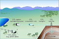
File:GeosequestrationProcess.JPG ...sequestration Sites by John G. Kaldi, Catherine M. Gibson-Poole, Tobias H. D. Payenberg, AAPG Studies in Geology 59, Carbon dioxide sequestration in geo(600 × 399 (131 KB)) - 15:54, 7 August 2014- As it arrives on tape from the [[Basic seismic processing|processor]], 3-D [[seismic data]] are organized into lines composed of [[trace]]s. In the co ...tal slices. From Liner.<ref name=Liner_1999>Liner, C., 1999. Elements of 3-D Seismology: Tulsa, PennWell.</ref> Courtesy PennWell.]]3 KB (373 words) - 19:06, 27 January 2022
File:M114CH01FG01.jpg ...r Faqira et al., 2009). MA-I and MA-II show the two areas selected for a 2-D basin modeling study. The Unayzah fields contain oil sourced by Qusaiba sha(685 × 692 (98 KB)) - 16:39, 28 December 2018
File:M98Ch3Fig4.JPG ...the Cambrian–Ordovician great American carbonate bank, in J. R. Derby, R. D. Fritz, S. A. Longacre, W. A. Morgan, and C. A. Sternbach, eds., The great(600 × 775 (326 KB)) - 16:42, 19 August 2014
File:Fluid-contacts fig2.png ...ology type, but pool contact is irregular due to reservoir heterogeneity. (d) Irregular contacts due to semipermeable barrier in an otherwise homogeneou(944 × 1,536 (55 KB)) - 01:51, 14 January 2014
File:H4CH12FG5.JPG ...ertainties in basin modeling, 2012, Hicks, P. J. Jr., C. M. Fraticelli, J. D. Shosa, M. J. Hardy, and M. B. Townsley, ''in'' Peters, Kenneth E., David J(600 × 707 (97 KB)) - 20:26, 9 July 2015
File:Using-and-improving-surface-models-built-by-computer fig13.png ...ach fault block is allowed to extend past faults defining the block edge. (d) When displayed, contours are constrained to inside the fault block polygon(926 × 1,096 (55 KB)) - 22:32, 13 January 2014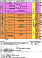
File:M98Ch3Fig1.JPG ...the Cambrian–Ordovician great American carbonate bank, in J. R. Derby, R. D. Fritz, S. A. Longacre, W. A. Morgan, and C. A. Sternbach, eds., The great(600 × 828 (256 KB)) - 16:27, 19 August 2014- | chapter = Interpreting 3-D seismic data ...f seismic attributes|attributes]] in a [[3-D seismic data: the data cube|3-D seismic]] survey:4 KB (562 words) - 19:42, 27 January 2022
File:H4CH12FG10.JPG ...ertainties in basin modeling, 2012, Hicks, P. J. Jr., C. M. Fraticelli, J. D. Shosa, M. J. Hardy, and M. B. Townsley, ''in'' Peters, Kenneth E., David J(600 × 439 (52 KB)) - 21:21, 13 July 2015- * Brown, D., 2011, [Anthropocene: An Epoch Debate https://archives.aapg.org/explorer/2583 bytes (70 words) - 19:14, 14 March 2019
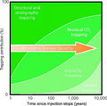
File:CO2TrappingMechanisms.JPG ...orage security with time. From Kaldi, J. G., C. M. Gibson-Poole, and T. H. D. Payenberg, 2009, Geological input to selection and evaluation of CO2 geose(600 × 596 (131 KB)) - 18:25, 7 August 2014- ...only contain hydrocarbons. In only 5 of the 33 reservoirs does Compartment D contain hydrocarbons. ...ly when Fault A is [[Cross-sealing faults|cross sealing]] does Compartment D contain hydrocarbons. Cross seal is created by shale-prone gouge with low s4 KB (515 words) - 21:31, 29 March 2022
File:Flow-units-for-reservoir-characterization fig2.png ...r basin, Wyoming. (Modified from Hearn et al., 1984.) (c) Lithofacies and (d) reservoir facies (flow unit) subdivision of the Rainbow Lake reef reservoi(2,737 × 1,751 (237 KB)) - 23:14, 14 January 2014- A3-D seismic survey is designed to give optimum results for a particular depth i * [[3-D seismic: the data cube]]3 KB (455 words) - 22:00, 25 January 2022
File:Lithofacies-and-environmental-analysis-of-clastic-depositional-systems fig3.png ...lative magnitude of permeability expected in such a sequence. (Parts c and d are from Walker, 1984, and parts f, h, and i are from Galloway and Hobday,(1,950 × 1,563 (201 KB)) - 21:37, 13 January 2014
File:CO2StorageOptions.JPG ...s Technologies [CO2CRC]). From Kaldi, J. G., C. M. Gibson-Poole, and T. H. D. Payenberg, 2009, Geological input to selection and evaluation of CO2 geose(800 × 570 (244 KB)) - 17:26, 7 August 2014
File:M31F7.jpg ...onment. From Deltaic environments of deposition, 1981, Coleman, J. M., and D. B. Prior, in AAPG Memoir 31.(1,366 × 1,004 (1.31 MB)) - 19:50, 15 August 2014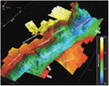
File:M115CH02FG02.jpg 3-D structural image of the South Viking Graben and southern part of the Centra(700 × 552 (112 KB)) - 20:30, 10 January 2019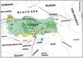
File:M106Ch13Fig02.jpg ...berlitaş, 17. Cendere, 18. Çukurtaş, 19. D. Beşikli, 20. D. Silivanka, 21. D. Yatir, 22. Şahaban, 23. Tokaris, 24. G. Şahaban, 25. Germik, 26. G. Sari(700 × 491 (61 KB)) - 19:34, 5 July 2016- * Reflection (including 2-D and 3-D) ...on the lines are a mixture of both in-plane and out-of-plane reflectors. 2-D reflection seismic data are most important in the earlier stages of an expl5 KB (712 words) - 21:27, 2 February 2022
- * Using 3-D seismic displays ...and coverts it to time. Put another way, forward modeling takes a 2-D or 3-D geological model and converts it to a simulated seismic section. The simula5 KB (720 words) - 18:51, 4 February 2022
- | author = G. Yielding, B. Freeman, and D. T. Needham ...mes, J. R., L. J. J. Zijerveld, R. C. M. W. Franssen, G. M. Ingram, and P. D. Richard, 1996, Fault seal processes, in Norwegian Petroleum Society, eds.,3 KB (437 words) - 20:02, 13 December 2016
File:Evaluating-structurally-complex-reservoirs fig1.png ...are (from left to right) azimuth versus depth (A plot), dip versus depth (D plot), dip versus depth in the direction of greatest curvature (T plot), di(1,933 × 1,167 (174 KB)) - 18:47, 14 January 2014- | chapter = Interpreting 3-D seismic data ...osion in the number of attributes that can be generated and displayed in 3-D interpretation systems. New attributes are added to the list regularly. Bec6 KB (859 words) - 19:42, 27 January 2022

File:H4CH12FG3.JPG ...ertainties in basin modeling, 2012, Hicks, P. J. Jr., C. M. Fraticelli, J. D. Shosa, M. J. Hardy, and M. B. Townsley, ''in'' Peters, Kenneth E., David J(600 × 252 (67 KB)) - 20:14, 9 July 2015
File:M31F2.jpg ...ations. From Deltaic environments of deposition, 1981, Coleman, J. M., and D. B. Prior, in AAPG Memoir 31.(365 × 772 (175 KB)) - 18:56, 15 August 2014
File:H4CH12FG12.JPG ...ertainties in basin modeling, 2012, Hicks, P. J. Jr., C. M. Fraticelli, J. D. Shosa, M. J. Hardy, and M. B. Townsley, in Peters, Kenneth E., David J. Cu(600 × 346 (51 KB)) - 21:41, 13 July 2015- ...n]] in the Black Warrior basin.<ref name=Bolandetal_1971>Boland, L. F., E. D. Minihan, and W. A. Thomas, 1971, [http://archives.datapages.com/data/bulle ...Basin. 20 mi (32 km). From Fritz et al.<ref name=Fritzetal_2012>Fritz, R. D., P. Medlock, M. Kuykendal, and J. L. Wilson, 2012, [http://archives.datapa2 KB (308 words) - 16:53, 26 March 2015
File:H4CH12FG13.JPG ...ertainties in basin modeling, 2012, Hicks, P. J. Jr., C. M. Fraticelli, J. D. Shosa, M. J. Hardy, and M. B. Townsley, in Peters, Kenneth E., David J. Cu(600 × 480 (128 KB)) - 21:42, 13 July 2015
File:H4CH12FG11.JPG ...ertainties in basin modeling, 2012, Hicks, P. J. Jr., C. M. Fraticelli, J. D. Shosa, M. J. Hardy, and M. B. Townsley, in Peters, Kenneth E., David J. Cu(600 × 322 (73 KB)) - 21:40, 13 July 2015
File:M98Ch3Fig2.JPG ...the Cambrian–Ordovician great American carbonate bank, in J. R. Derby, R. D. Fritz, S. A. Longacre, W. A. Morgan, and C. A. Sternbach, eds., The great(600 × 898 (278 KB)) - 16:31, 19 August 2014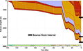
File:H4CH12FG4.JPG ...ertainties in basin modeling, 2012, Hicks, P. J. Jr., C. M. Fraticelli, J. D. Shosa, M. J. Hardy, and M. B. Townsley, ''in'' Peters, Kenneth E., David J(600 × 369 (82 KB)) - 20:20, 9 July 2015- ...sported away, and are no longer subject to the thermal conditions of the 1-D model. '''Closed-system''' models assume the hydrocarbons have not been exp ...open- and closed-system modeling conditions. Copyright: results of Genex 1-D basin modeling software, courtesy Institute Français du Petrole.]]3 KB (398 words) - 15:15, 14 February 2022
- ...e, A., A., Guliyev, I., S., Suleymanova, S., F., Ateava, E., Z., Mamedova, D., N., Koshkarly, R., O., 1998, [http://archives.datapages.com/data/bulletns * Stockmal, G., S., MacKay, P., A., Lawton, D., C., Spratt, D., A., 1996, The Oldman River triangle zone: a complicated tectonic wedge de4 KB (557 words) - 20:06, 2 February 2022
File:Mth14ch02f03.jpg ...he fan eastward toward the fan margin. From M. S. Clark, R. K. Prather, J. D. Melvin, 2003, Characterization and Exploitation of the Distal Margin of a(700 × 529 (75 KB)) - 15:26, 4 December 2015- ...re permeability can be as high as tens of darcys<ref name=ch10r80>Stearns, D., W., Friedman, M., 1972, Reservoirs in fractured rock: AAPG Memoir 16, p. ...oint seep]] in the Santa Barbara Channel, California, is leaking 50–70 bbl/d or more than 25 billion bbl/m.y.<ref name=ch10r95>Wilkinson, E., R., 1971,3 KB (403 words) - 15:21, 30 March 2022
- ...Utah]: AAPG Search and Discovery Article No. 110014</ref><ref>Strickland, D., 2009, [http://player.piksel.com/player.php?v=bl432u69 Conventional Wisdom ...Johnson, D. D. Schelling, D. A. Sprinkel, D. K. Strickland, J. P. Vrona, & D. A. Wavrek, 2007, Central Utah: Diverse Geology of a Dynamic Landscape, Pet6 KB (897 words) - 19:39, 14 February 2017
File:Mth14ch02f06.jpg ...fluid communication with one another. From M. S. Clark, R. K. Prather, J. D. Melvin, 2003, Characterization and Exploitation of the Distal Margin of a(700 × 481 (51 KB)) - 17:48, 4 December 2015- ...times (1 - \phi) \times \mbox{d}] + [\rho_{\rm w} \times \phi \times \mbox{d}]</math> * d = depth (ft)3 KB (402 words) - 14:47, 16 February 2022
- ..., R. S., 2000, Approaches to defining reservoir physical properties from 3-D seismic attributes with limited well control: an example from the Jurassic2 KB (298 words) - 21:30, 21 November 2014
- ...d in maintaining this wiki, please [mailto:[email protected] get in touch!] We'd love to hear from you.2 KB (254 words) - 19:25, 27 March 2014
File:ST53Part01Pg11B.jpg ...-Related Folds, An AAPG Seismic Atlas, edited by John H. Shaw, Christopher D. Connors and John Suppe, 2005. Pages 1-59.(750 × 511 (141 KB)) - 16:33, 28 July 2015
File:H4CH12FG2.JPG ...ertainties in basin modeling, 2012, Hicks, P. J. Jr., C. M. Fraticelli, J. D. Shosa, M. J. Hardy, and M. B. Townsley, ''in'' Peters, Kenneth E., David J(800 × 581 (246 KB)) - 20:11, 9 July 2015- ...ssissippi River depositional system: model for the Gulf Coast Tertiary, in D. Goldthwaite, ed., An Introduction to Central Gulf Coast Geology: New Orlea ...Late Cretaceous to Holocene. After Winker;<ref name=Winker1982>Winker, C. D., 1982, Cenozoic shelf margins, northwestern Gulf of Mexico: Gulf Coast Ass3 KB (406 words) - 17:03, 22 February 2022
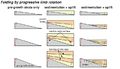
File:AlHawajAlQahtaniFigure6.jpg ...A) Faulted horizon surface. The small black box is the location of B-E. B-D) Channels lateral geometry on different horizon levels. E) Restoration usin(468 × 439 (80 KB)) - 21:05, 8 November 2021- ...d in maintaining this wiki, please [mailto:[email protected] get in touch!] We'd love to hear from you.2 KB (264 words) - 16:58, 31 March 2014
File:Mth14ch02f04.jpg ...o the direction of sediment transport. From M. S. Clark, R. K. Prather, J. D. Melvin, 2003, Characterization and Exploitation of the Distal Margin of a(500 × 605 (114 KB)) - 15:58, 4 December 2015
File:Mth14ch02f01.jpg ...its A and B to the anticlinal closure. From M. S. Clark, R. K. Prather, J. D. Melvin, 2003, Characterization and Exploitation of the Distal Margin of a(700 × 457 (103 KB)) - 23:18, 3 December 2015
File:Mth14ch02f07.jpg ...nts with different oil-water contacts. From M. S. Clark, R. K. Prather, J. D. Melvin, 2003, Characterization and Exploitation of the Distal Margin of a(700 × 449 (53 KB)) - 19:56, 4 December 2015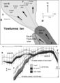
File:Mth14ch02f05.jpg ...ontacts in the lobes of Units A and B. From M. S. Clark, R. K. Prather, J. D. Melvin, 2003, Characterization and Exploitation of the Distal Margin of a(500 × 682 (64 KB)) - 17:07, 4 December 2015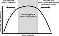
File:H4CH12FG8.JPG ...ertainties in basin modeling, 2012, Hicks, P. J. Jr., C. M. Fraticelli, J. D. Shosa, M. J. Hardy, and M. B. Townsley, ''in'' Peters, Kenneth E., David J(600 × 372 (49 KB)) - 20:32, 13 July 2015
File:Mthch02f02.jpg ...st of the oil produced from the basin. From M. S. Clark, R. K. Prather, J. D. Melvin, 2003, Characterization and Exploitation of the Distal Margin of a(300 × 453 (36 KB)) - 15:19, 4 December 2015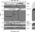
File:Mth14ch02f09.jpg ...bility pathways that parallel bedding. From M. S. Clark, R. K. Prather, J. D. Melvin, 2003, Characterization and Exploitation of the Distal Margin of a(600 × 541 (60 KB)) - 20:21, 4 December 2015- ...eochemistry as an exploration tool in the South Caribbean], in Schumacher, D., Abrams, M., A., eds., Hydrocarbon Migration and Its Near-Surface Expressi ...(April 3), p. 66–71.</ref> and Saunders et al.<ref name=ch18r36>Saunders, D., F., Burson, K., R., Brown, J., J., Thompson, C., K., 1993, [http://archiv8 KB (1,055 words) - 16:29, 25 January 2022
File:H4CH12FG1.JPG ...ertainties in basin modeling, 2012, Hicks, P. J. Jr., C. M. Fraticelli, J. D. Shosa, M. J. Hardy, and M. B. Townsley, in Peters, Kenneth E., David J. Cu(600 × 378 (60 KB)) - 19:59, 9 July 2015- ...ail.aspx?id=75 AAPG Memoir 66], p. 71–89.</ref><ref name=ch18r37>Saunders, D. F., K. R. Burson, J. J. Brown, and C. K. Thompson, 1999, [http://archives.4 KB (493 words) - 22:00, 31 January 2022
- | chapter = Interpreting 3-D seismic data ...opicker works. © Dorn.<ref name=Dorn_1998>Dorn, G. A., 1998, Modern 3-D seismic interpretation: The Leading Edge, v. 17, no. 9, p. 1262-1272.</ref>8 KB (1,155 words) - 19:12, 27 January 2022
File:H4CH12FG7.JPG ...ertainties in basin modeling, 2012, Hicks, P. J. Jr., C. M. Fraticelli, J. D. Shosa, M. J. Hardy, and M. B. Townsley, ''in'' Peters, Kenneth E., David J(600 × 599 (51 KB)) - 21:12, 9 July 2015- ...e key to using seepage in exploration: the spectrum of seepage styles], in D. Schumacher, and M. A. Abrams, eds., Hydrocarbon Migration and Its Near-Sur ...m Surface geochemistry as an exploration tool in the South Caribbean], in D. Schumacher, and M. A. Abrams, eds., Hydrocarbon Migration and Its Near-Sur8 KB (1,128 words) - 22:24, 31 January 2022
File:ST53Part01Pg14A.jpg ...-Related Folds, An AAPG Seismic Atlas, edited by John H. Shaw, Christopher D. Connors and John Suppe, 2005. Pages 1-59.(750 × 524 (88 KB)) - 20:45, 28 July 2015- The [[displacement pressure]] (P<sub>d</sub>) is routinely inferred by forcing mercury into the pore space of a sa Displacement pressure (P<sub>d</sub>) is defined as the pressure necessary to form a continuous hydrocarbo5 KB (749 words) - 19:46, 31 March 2022
- ...h17r55>Lawrence, D. R., 1979, Taphonomy, in Fairbridge, R., W., Jablonski, D., eds., The Encyclopedia of [[Paleontology]]: Stroudsburg, Pennsylvania, Do ...1990, Destructive taphonomic processes and skeletal durability, in Briggs, D., E., G., Crowther, P., R., eds., Palaeobiology: A Synthesis: Oxford, Black3 KB (449 words) - 18:12, 31 January 2022
- | author = G. Yielding, B. Freeman, and D. T. Needham911 bytes (124 words) - 13:49, 18 March 2019
- ...lett, T. S., 1993, Natural gas production from arctic gas hydrates, ''in'' D. G. Howell, ed., [http://pubs.er.usgs.gov/publication/pp1570 The future of7 KB (1,050 words) - 20:53, 6 January 2015
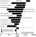
- ...r|1}}From Hartmann and Coalson.<ref name=Hartmannandcoalson_1990>Hartmann, D. J., and E. B. Coalson, 1990, Evaluation of the Morrow sandstone in Sorrent ...> = 45%). This is verified by the well testing about 100 bo/d and 300 Mcfg/d (16 m<sup>3</sup> oil and 8,500 m<sup>3</sup>gas per day) with no water fro7 KB (956 words) - 17:24, 11 April 2022
- ...s also incorporate functions and algorithms that permit some rudimentary 3-D balancing of structures. * Buchanan, P. G., and D. A. Nieuwland, eds., 1996, Modern Developments in Structural Interpretation8 KB (1,060 words) - 15:07, 3 February 2022
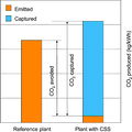
File:CO2EmissionsComparison.JPG ...rbon capture and storage. From Kaldi, J. G., C. M. Gibson-Poole, and T. H. D. Payenberg, 2009, Geological input to selection and evaluation of CO2 geose(600 × 600 (75 KB)) - 16:14, 7 August 2014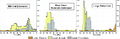
File:H4CH12FG9.JPG ...ertainties in basin modeling, 2012, Hicks, P. J. Jr., C. M. Fraticelli, J. D. Shosa, M. J. Hardy, and M. B. Townsley, ''in'' Peters, Kenneth E., David J(800 × 262 (80 KB)) - 20:34, 13 July 2015- ...ult-seal_fig10-1.png|{{figure number|1}}Two sands, R<sub>u</sub> and R<sub>d</sub>, juxtaposed by a fault. The two sands have common oil-water (OWC) an ...fault-seal_fig10-1.png|Figure 1]] shows two sands, R<sub>u</sub> and R<sub>d</sub>, juxtaposed by a fault. The two sands have common [http://www.glossar8 KB (1,155 words) - 21:31, 24 March 2022
- ...omplex, lower Wilcox Group (Paleocene), central Texas coastal plain, in R. D. Winn, Jr., and J. M. Armentrout, eds., Turbidites and Associated Deep-Wate4 KB (494 words) - 13:44, 5 December 2023
- * Smith, D. A., 1980, [http://archives.datapages.com/data/bulletns/1980-81/data/pg/006 * Finkbeiner, T., C. A. Barton, and M. D. Zoback, 1997, [http://archives.datapages.com/data/bulletns/1997/12dec/19755 KB (638 words) - 14:17, 2 February 2022
- ...controlled instead by fault-dependent leak points.<ref name=ch10r3>Allard, D. M., 1993, Fault leak controlled trap fill, rift basin examples (abs.), in ...ghts controlled by top seal capillary properties<ref name=ch10r98>Zieglar, D. M., 1992, [http://archives.datapages.com/data/bulletns/1992-93/data/pg/0074 KB (556 words) - 20:56, 31 March 2022
- file:sedimentary-basin-analysis_fig4-53.png|{{figure number|1}}32-layer, 1-D mathematical model constructed for the East Breaks 160-161 minibasin. After A 32-layer, 1-D mathematical model ([[:file:sedimentary-basin-analysis_fig4-53.png|Figure 16 KB (850 words) - 15:33, 23 March 2022
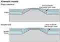
- * Soule, G. S., Spratt, D. A., 1996, En echelon geometry and two-dimensional model of the triangle zo ...diapirs on the Tihama plain, northwest Yemen, in Alsop, G., I., Blundell, D., J., Davison, I., eds., Salt Tectonics: Geological Society of London Speci4 KB (579 words) - 20:52, 2 February 2022
- :<math>\mbox{P}_{\rm d} = \frac{-2\gamma \cos \theta}{\mbox{r}}</math> ...no. 2, p. 337–349., 10., 1016/0021-9797(74)90265-3</ref><ref>Etris, E. L., D. S. Brumfield, R. Ehrlich, R. and S. J. Crabtree, 1988, Relation between po5 KB (766 words) - 22:55, 2 February 2016
- ...rvoir quality in Lower Tertiary sandstones along the Texas Gulf Coast], in D. A. McDonald and R. C. Surdam, eds., Clastic Diagenesis: AAPG Memoir 37, p. ...sandstone geometry, texture and composition, and fluid flux], in McDonald, D., A., Surdam, R., C., eds., Clastic Diagenesis: AAPG Memoir 37, p. 289–315 KB (729 words) - 20:48, 5 April 2022
- ...rvoir-system-quality-and-performance_fig9-9.png|Figure 1]] shows typical 3-D pore system geometries found in intergranular, intercrystalline, vuggy, or ...uality-and-performance_fig9-9.png|300px|thumb|{{figure number|1}}Typical 3-D pore system geometries found in intergranular, intercrystalline, vuggy, or3 KB (388 words) - 13:52, 4 April 2022
- ...cture is small compared with fracture length.<ref name=ch02r10>Pollard, D. D., and P. Segall, 1987, Theoretical displacements add stresses near fracture3 KB (461 words) - 16:04, 13 April 2022
- ...tional, 4356 p.</ref><ref name=ch10r97>Yielding, G., Freeman, B., Needham, D., T., 1997, [http://archives.datapages.com/data/bulletns/1997/06jun/0897/08 ..., p. 1372–1385.</ref><ref name=ch10r97>Yielding, G., Freeman, B., Needham, D., T., 1997, Quantitative fault seal prediction: AAPG Bulletin, vol. 81, no.9 KB (1,327 words) - 16:32, 29 March 2022
- ...etin, v. 63, p. 1016-1058.</ref> and Lowell.<ref name=ch20r215>Lowell, J., D., 1985, Structural Styles in Petroleum Exploration: Tulsa, OGCI, 460 p.</re3 KB (420 words) - 20:13, 3 February 2022
File:H4CH12FG6.JPG ...ertainties in basin modeling, 2012, Hicks, P. J. Jr., C. M. Fraticelli, J. D. Shosa, M. J. Hardy, and M. B. Townsley, ''in'' Peters, Kenneth E., David J(600 × 611 (85 KB)) - 21:07, 9 July 2015- * Aiding 2-D and 3-D [[seismic interpretation]]s * Laying out new 2-D and 3-D seismic programs9 KB (1,274 words) - 17:59, 24 January 2022
- The example given in this section is a small 3-D data set from the Glenn Pool field in northeastern Oklahoma. The target is ...f the survey. Copyright: Liner;<ref name=Liner>Liner, Chris, Elements of 3-D Seismology: Tulsa, PennWell, 1999.</ref> courtesy PennWell.]]7 KB (1,064 words) - 19:11, 27 January 2022
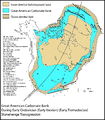
File:M98Ch2Fig1.JPG ...cian (early Tremadocian): The Stonehenge transgression, in J. R. Derby, R. D. Fritz, S. A. Longacre, W. A. Morgan, and C. A. Sternbach, eds., The great(800 × 915 (269 KB)) - 16:14, 19 August 2014- ...]: AAPG Bulletin, vol. 36, p. 1505–1541.</ref><ref name=ch18r23>Macgregor, D. S., 1993, Relationships between seepage, tectonics, and subsurface petrole ....com/data/specpubs/memoir66/11/0139.htm Migration a view from the top], in D. Schumacher, and M. A. Abrams, eds., Hydrocarbon Migration and Its Near-Sur6 KB (754 words) - 22:07, 24 January 2022
- ...3.htm Importance of sampling design and density in target recognition], in D. Schumacher and M. A. Abrams, eds., Hydrocarbon Migration and Its Near-Surf ...ng geochemical grids is recommended for small exploration targets and/or 3-D seismic programs; however, grids are not cost effective for large reconnais6 KB (826 words) - 17:33, 25 January 2022
- ...are clearly presented in Tearpock and Bischke.<ref name=ch04r94>Tearpock, D., J., Bischke, R., E., 1991, Applied Subsurface Geologic Mapping: Prentice- ...Late Cretaceous to recently. After Winker;<ref name=Winker1982>Winker, C. D., Cenozoic shelf margins, northwestern Gulf of Mexico: Gulf Coast Assoc. of11 KB (1,496 words) - 18:17, 22 February 2022
- ...ck]: AAPG Bulletin, vol. 65, no. 5, p. 964.</ref><ref name=ch10r75>Slujik, D., Nederlof, M., H., 1984, [http://archives.datapages.com/data/specpubs/geoc3 KB (464 words) - 20:56, 31 March 2022
- ...tion Circular 40 (Li et al.<ref name=Lietal>Li, Peng, M. E. Ratchford, and D. M. Jarvie, 2010, Geochemistry and thermal maturity analysis of the Fayette5 KB (645 words) - 22:38, 2 June 2021
File:ST53Part01Pg12B.jpg ...-Related Folds, An AAPG Seismic Atlas, edited by John H. Shaw, Christopher D. Connors and John Suppe, 2005. Pages 1-59.(750 × 431 (84 KB)) - 16:59, 28 July 2015- ...Wyoming, Montana, South Dakota, and Nebraska, ''in'' P. D. Warwick and M. D. Corum, eds., Geologic framework for the national assessment of carbon diox4 KB (677 words) - 17:14, 22 December 2023
- ...d in maintaining this wiki, please [mailto:[email protected] get in touch!] We'd love to hear from you.2 KB (240 words) - 23:20, 1 February 2023
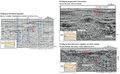
- ...a river channel zone. Copyright: the Taber area of southern Alberta. The 3-D survey was done in the area outlined by the rectangle in the center of the ...ic-inversion_fig6.png|{{figure number|6}}Time slice displays through the 3-D survey of the river channel zone. The lightly shaded areas show low velocit8 KB (1,196 words) - 18:48, 21 January 2022
- ...nd Shea et al..<ref name=ch10r68>Shea, W., T., Schwalbach, J., R., Allard, D., M., 1993, Integrated rock-log evaluation of fluvio-lacustrine seals, in E5 KB (760 words) - 20:55, 31 March 2022
- ...ydrocarbon accumulation column height.<ref name=HartmannBeaumont>Hartmann, D. J., and E. A. Beaumont, [http://archives.datapages.com/data/specpubs/beaum1 KB (206 words) - 17:37, 27 January 2015
- ...htm Hydrocarbon-induced alteration of soils and sediments], in Schumacher, D., Abrams, M., A., eds., Hydrocarbon Migration and Its Near-Surface Expressi ..., p. 299–309.</ref> Saunders et al. (general),<ref name=ch18r37>Saunders, D., F., Burson, K., R., Brown, J., J., Thompson, C., K., 1999, [http://archiv10 KB (1,443 words) - 16:08, 25 January 2022
- ...>Buffler, R. T., 1991, Early evolution of the Gulf of Mexico basin, ''in'' D. Goldthwaite, ed., An introduction to Central Gulf Coast geology: New Orlea ...ing the margins to retreat landward. From Hall et al.;<ref name=Hall>Hall, D. J., B. E. Bowen, R. N. Rosen, S. Wu, and A. W. Bally, 1993, Mesozoic and e7 KB (1,044 words) - 16:34, 22 February 2022
- ...stribution, and fluid recovery in a reservoir.<ref name=Treatise>Hartmann, D. J., and E. A. Beaumont, [http://archives.datapages.com/data/specpubs/beaum1 KB (183 words) - 18:19, 26 March 2015
- | author = G. Asquith and D. Krygowski ...y have low resistivity.<ref name=AsquithandKrygowski_2006>Asquith, G., and D. Krygowski, 2006, Basic Well Log Analysis, 2nd Edition: [http://store.aapg.4 KB (543 words) - 14:11, 21 August 2014
- .../a067/0001/0050/0069.htm Diagenetic pathways in sedimentary basins], in A. D. Horbury, and A. G. Robinson, eds., Diagenesis and Basin Development: AAPG ...n, M. D., 1994a, Non-compositional controls on diagenetic processes, in M. D. Wilson, ed., Reservoir Quality Assessment and Prediction in Clastic Rocks:6 KB (787 words) - 13:43, 6 April 2022
- ...for each kerogen type in a basin. This relationship can be derived using 1-D basin [[modeling]] techniques. ...umber|1}}Hydrocarbon generation-depth curve. Copyright: results of Genex 1-D basin modeling software, courtesy Institute Français du Petrole.]]4 KB (503 words) - 14:18, 14 February 2022
- * Detailed seismic, 2-D and 3-D (structural geometry)4 KB (511 words) - 18:50, 3 February 2022
File:M115CH02FG03.jpg ...aben|Zanella et al. (2003)]]. Bi = Birch; Br = Braemar; CB = Central Brae; D = Devenick; EB = East Brae; G = Gudrun; JS = John Sverdrup; K = Kingfisher;(700 × 767 (157 KB)) - 21:29, 10 January 2019- ...he fault will [[Cross-leaking faults|cross-leak]].<ref name=ch10r76>Smith, D. A., 1966, [http://archives.datapages.com/data/bulletns/1965-67/data/pg/005 .../data/pg/0077/0008/1350/1389.htm Akaso field, Nigeria: use of integrated 3-D seismic, fault-slicing, clay smearing and RFT pressure data on fault trappi4 KB (530 words) - 15:21, 30 March 2022
- ...measured must be corrected for the earth's field.<ref name=ch15r2>Chapin, D. A., 1996a, [http://library.seg.org/doi/abs/10.1190/1.1437341 The theory of ...ffect can be made if the data set is large enough.<ref name=ch15r3>Chapin, D. A., 1996b, A deterministic approach towards computing isostatic gravity re4 KB (519 words) - 14:16, 31 January 2022
- [[file:applying-magnetotellurics_fig16-6.png|300px|thumb|{{figure number|1}}2-D MT model beneath the Angore-1 well and the base of the Darai Limestone as o [[:file:applying-magnetotellurics_fig16-6.png|Figure 1]] shows the 2-D MT model beneath the Angore-1 well and the base of the Darai Limestone as o4 KB (520 words) - 15:12, 31 January 2022
- ...nt of the fields (up until 2007), is outlined by Martineau.<ref>Martineau, D. F., 2007, [http://archives.datapages.com/data/bulletns/2007/04apr/INTRODUC ...tt-Paleozoic Total Petroleum System. From Pollastro.<ref>Pollastro, R. M., D. M. Jarvie, R. J. Hill, & C. W. Adams, 2007, [http://archives.datapages.com6 KB (909 words) - 19:24, 14 March 2019
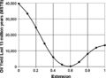
- ...ery (''E''<sub>R</sub>) is a product of displacement efficiency (''E''<sub>D</sub>), invasion or vertical sweep efficiency (''E''<sub>V</sub>) and the p :<math>E_{\rm R} = E_{\rm D} \times E_{\rm V} \times E_{\rm P}</math>10 KB (1,468 words) - 18:23, 21 January 2022
- ...the [[hanging wall]] and [[footwall]] cutoffs.<ref name=ch10r86>Van Wijhe, D. H., M. Lutz, and J. P. H. Kaasschieter, 1980, The Rotliegend in the Nether ...the lowest sand is limited by either the [[displacement pressure]] (P<sub>d</sub>) of the fault zone, the [[Calculating charge volume|charge volume]],9 KB (1,461 words) - 21:57, 28 March 2022
- * Oil drainage (K<sub>ro-D</sub>)—reflects migrating oil displacing water (decreasing S<sub>w</sub>) ...to flow while oil flow approaches its maximum. At point D on the K<sub>ro-D</sub> curve (S<sub>w</sub> ≈ 20%, S<sub>o</sub> ≈ 80%), relative permea9 KB (1,351 words) - 13:31, 5 April 2022
- ...the GOM basin. From Winker & Buffler;<ref name=WinkerandBuffler>Winker, C. D., and R. T. Buffler, 1988, [http://archives.datapages.com/data/bulletns/198 ...co from Late Cretaceous to Recent. After Winker.<ref name=ch04r114>Winker, D. C., Cenozoic shelf margins, northwestern Gulf of Mexico: Gulf Coast Associ5 KB (753 words) - 19:58, 18 February 2022
- ...and hydrocarbon occurrence between and beyond data control. Both 2-D and 3-D simulation programs are available or in development. With high-resolution i ...were input in a commercially available simulation package that performs 2-D [[backstripping]] and calculates subsidence rates and sediment flux rates a7 KB (895 words) - 16:18, 24 March 2022
- .... 1, p. 107–114., 10., 1144/jm., 1., 1., 107</ref><ref name=ch17r9>Batten, D., J., Morrison, J., 1983, Methods of palynological preparation for paleoenv6 KB (805 words) - 18:09, 24 January 2022
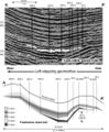
- ...ure map gives a good feel for the additional information supplied by the 3-D seismic section. ...or the Wilcox. From Liner.<ref name=Liner_1999>Liner, Chris, Elements of 3-D Seismology: Tulsa, PennWell.</ref> Courtesy PennWell.7 KB (1,117 words) - 17:51, 25 January 2022
- .... 23-50.</ref> Jamison et al.<ref name=Jamisonetal_1980>Jamison, H. C., L. D. Brockett, and R. A. McIntosh, 1980, [http://archives.datapages.com/data/sp ...ef> McGowen et al.<ref name=Mcgowenetal_1987>McGowan, J. H., S. Bloch, and D. Hite, 1987, Depositional facies, diagenesis, and reservoir quality of Ivis11 KB (1,634 words) - 16:34, 26 April 2016
- [[Displacement pressure]] (P<sub>d</sub>) is the pressure necessary to force hydrocarbons into the pore space :<math>\mbox{P}_{\rm d} = \frac{(2\gamma \cos \theta)}{\mbox{R}}</math>4 KB (530 words) - 15:56, 31 March 2022
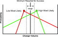
- .... 6, p. 840–850.</ref><ref name=ch10r68>Shea, W. T., J. R. Schwalbach, and D. M. Allard, 1993, Integrated rock-log evaluation of fluvio-lacustrine seals ...ss#Probability_of_geological_success|risk]] was defined by combining P<sub>d</sub> with qualitative assessments of [[ductility]], [[Fracture|fracturing]5 KB (764 words) - 19:46, 31 March 2022
- ...of 18,544 feet. It had an initial production rate of 5MMcf/d and 1,200bbl/d while being choked back. With the completion of this well Eclipse Resources3 KB (542 words) - 22:36, 4 March 2022
- ...v. I-2: Geological Society of America, p. 177–196.</ref> Gravity model by D.R. Hutchinson and J.A. Grow (1980),{{citation needed}} courtesy USGS.]] ...odified version of Talwani et. al. 1959 method of gravity modeling for a 2-D geometry. Caution: there are numerous errors in this paper. This is the met6 KB (915 words) - 15:10, 31 January 2022
- ...name=Kng2012>Kuang, L., Y. Tang, D. Lei, Q. Chang, M. Ouyang, L. Hou, and D. Liu, 2012, Formation conditions and exploration potential of tight oil in ...“upper sweet section” of this formation in 2012, initially produced 77.8 t/d<ref name=Kng2012 />. Then, significant progress was made using new methods6 KB (850 words) - 17:56, 20 December 2023
- ...nction of sandstone geometry, texture and composition, and fluid flux], in D. A. McDonald, and R. C. Surdam eds., Clastic Diagenesis: AAPG Memoir 37, p. ...m Facies controls on early diagenesis: Wilcox Group, Texas Gulf Coast], in D. Meshri and P. J. Ortoleva, eds., Prediction of Reservoir Quality Through C8 KB (1,129 words) - 14:11, 6 April 2022
- ...Beaumont, Norman H. Foster, Richard R. Vincelette, Marlan W. Downey, James D. Robertson ...t a short time ago. This has allowed us, for example, to develop 3-D and 4-D [[seismic data]] gathering and processing. In addition, computers allow us6 KB (826 words) - 14:29, 18 February 2022
- {{Annotation|97|130|[[Late Devonian extinction|Late D]]}}2 KB (186 words) - 15:15, 23 January 2014
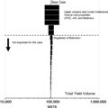
- ...iston Basin, USA, ''in'' Bruce Hart, Norman C. Rosen, Dorene West, Anthony D’Agostino, Carlo Messina, Michael Hoffman, Richard Wild, eds., Sequence St | Current Oil Production (bo/d) || [[:file:Figure3Bakken2019-20CommRpt.jpg|Figure 3]]11 KB (1,595 words) - 20:20, 2 June 2021
File:BLTN12220fig5.jpg ...row) with bitumen and oil inclusions, well LJ6, 3936.00 m (12,910.08 ft). (D) Two-phase aqueous fluid inclusions (yellow arrow), bitumen, and oil inclus(444 × 500 (324 KB)) - 13:22, 13 August 2014- ...p. 391–397.</ref><ref name=ch04r46>Ingram, R. J., 1991, Salt tectonics, in D. Goldthwaite, ed., An Introduction to Central Gulf Coast Geology: New Orlea ...Annual Research conference, p. 135–142.</ref><ref name=ch04r66>McGuinness, D. B., and J. R. Hossack, 1993, The development of allochthonous salt sheets7 KB (970 words) - 20:33, 18 February 2022
- * Watson, M. P., A. B. Hayward, D. N. Parkinson, and Z. M. Zhang, 1987, [http://www.sciencedirect.com/science * Harding, T. P., and J. D. Lowell, 1979, [http://archives.datapages.com/data/bulletns/1977-79/data/pg4 KB (601 words) - 18:22, 2 February 2022
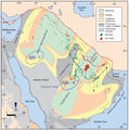
- ...of a magmatic arc along the western edge of Gondwana<ref>Veiga, R. D., G. D. Vergani, I. E. Brisson, C. E. Macellari, and H. A. Leanza, 2020, [https:// ...GS Fact Sheet], FactSheet_3col v. 4.1 </ref><ref>Mayol, J. C., N. Moridis, D. A. McVay, and J. W. Lee, 2020, Assessment of Oil and Gas Resources in the11 KB (1,644 words) - 16:14, 11 May 2023
- ...study by Hartmann and Coalson.<ref name=Hartmannandcoalson_1990>Hartmann, D. J., and E. B. Coalson, 1990, Evaluation of the Morrow Sandstone in Sorrent ...everal fields in the area <ref name=Sonnenbergetal_1991>Sonnenberg, S. A., D. J. McKenna, and P. J. McKenna, 1991, Sorrento field—U.S.A. Denver Basin,7 KB (1,044 words) - 16:57, 13 April 2022
- ...the petroleum and coal industries.<ref name=ch17r36>Dow, W., G., O'Connor, D., I., 1982, Kerogen maturity and type by reflected light microscopy applied ...90)90006-3</ref> and foraminifera<ref name=ch17r64>McNeil, D., H., Issler, D., R., 1992, Correlation of foraminiferal coloration (FCI) and time-temperat8 KB (1,113 words) - 18:10, 24 January 2022
- ...feedback and association, through an extensive research and development (R&D) investment, to maximize the value of their oil and gas assets,moreover tim2 KB (263 words) - 03:59, 18 June 2019
- ...ufficient for event identification and [[3-D seismic data: the data cube|3-D seismic data]] calibration.5 KB (805 words) - 19:06, 27 January 2022
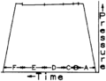
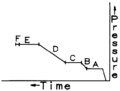
- '''Points D to D'''′ are the pressures recorded during the next flow period. This flow per ...pressure. A graphical procedure devised by Horner<ref name=ch05r10>Horner, D. R., 1951, Pressure build-up in wells: Proceedings of the Third World Petro6 KB (997 words) - 17:55, 17 February 2022
- ...gical Society Special Publication 7, p.71-82.</ref><ref name=ch09r33>Kent, D. M., F. M. Haidl, and J. A. MacEachern, 1988, Mississippian oil fields in t6 KB (848 words) - 17:34, 3 January 2024
- ...stimulation.<ref name=Mastersetal_1983>Masters, C. D., D. H. Root, and W. D. Dietzman, 1983, [http://pubs.er.usgs.gov/publication/ofr83728 Distribution7 KB (1,012 words) - 13:40, 18 March 2019
- ...htm Hydrocarbon-induced alteration of soils and sediments], in Schumacher, D., Abrams, M., A., eds., Hydrocarbon Migration and Its Near-Surface Expressi5 KB (687 words) - 19:23, 24 January 2022
- ...ctice, the [[Top seal displacement pressure|displacement pressure]] (P<sub>d</sub>) is estimated from laboratory measurements. In real rocks, the single2 KB (258 words) - 18:41, 31 March 2022
- ...revised Cenozoic geochronology and chronostratigraphy, in W. A. Berggren, D. V. Kent, M.-P. Aubry, and J. Hardenbol, eds., Geochronology, Time Scales, ...>Harland, W. B., R. L. Armstrong, A. V. Cox, L. E. Craig, A. G. Smith, and D. G. Smith, 1990, A Geologic Time Scale—Revised Edition: Cambridge, Cambri11 KB (1,595 words) - 18:09, 24 January 2022
- ...>Buffler, R. T., 1991, Early evolution of the Gulf of Mexico basin, ''in'' D. Goldthwaite, ed., An introduction to Central Gulf Coast geology: New Orlea sedimentary-basin-analysis_fig4-55.png|{{figure number|4}}North–south 3-D seismic reflection profile illustrating three possible hydrocarbon migratio8 KB (1,069 words) - 20:03, 18 February 2022
- | align="center"| δ || delta || 235 || d || &delta; || \delta2 KB (296 words) - 16:57, 14 January 2014
- ...d their implications for reservoir prediction, in Hartley, A. J., Prosser, D. J., eds., Characterization of Deep Marine Clastic Systems: Geological Soci ...on Special Publication 117, p. 94–124.</ref><ref name=ch04r115>Winker, C., D., 1996, High-resolution seismic stratigraphy of a late Pleistocene submarin11 KB (1,482 words) - 15:47, 21 March 2022
- ...ndon Memoir 10, p. 141–195.</ref><ref name=ch17r13>Berggren, W., A., Kent, D., and J.A. van Couvering, 1985b, Neogene geochronology and chronostratig- r ...ne-Pleistocene.<ref name=ch17r75>Ruddiman, W. F., Raymo, M. E., Martinson, D. G., Clement, B. M., Backman, J., 1989, Pleistocene evolution: Northern Hem9 KB (1,282 words) - 20:59, 31 January 2022
- | P || Hydrostatic pressure at depth d || psi | D || Vertical depth || ft21 KB (3,142 words) - 15:10, 24 January 2022
- * The words sorted and sorting, because i knew I'd never find this bit of info again Core_description#Maturity 8-26-14 * 4-D seismic data4 KB (584 words) - 21:29, 13 October 2014
- ...ied out back to old wells, industrial oil flows varying from 6.3 to 44.0 t/d have been obtained after fracturing (Song et al., 2020). 8.Zhao, X., L. Zhou, X. Pu, F. Jin, W. Han, D. Xiao, S. Chen, Z. Shi, W. Zhang, and F. Yang, 2018, Geological characteris8 KB (1,251 words) - 15:51, 14 March 2022
- #*:<math>\mbox{T}_{\rm f} = \mbox{T}_{\rm s} + \mbox{D}_{\rm f} \left(\mbox{BHT} - \frac{\mbox{T}_{\rm s}}{\mbox{TD}}\right)</math #*::: D<sub>f</sub> = depth to the formation (ft)5 KB (714 words) - 15:19, 13 September 2022
- ...based on identical burial and thermal conditions. From results of Genex 1-D basin modeling software, courtesy Institute Français du Petrole.]] ..., L'evolution thermique de la matiere organique des sediments: aplications d'une simulation mathematique: Rev. IFP, vol. 30, p. 743–777, DOI: 10.2516/5 KB (651 words) - 16:11, 10 February 2022
- Surdam et al.<ref name=ch09r61>Surdam, R., C., Dunn, T., L., MacGowan, D., B., Heasler, H., P., 1989, Conceptual models for the prediction of porosi ...1994a, Non-compositional controls on diagenetic processes, in Wilson, M., D., ed., [[Reservoir quality]] Assessment and Prediction in Clastic Rocks: SE7 KB (870 words) - 20:30, 5 April 2022
- ...above or below the normal static water pressure.<ref name=ch05r14>Powley, D., E., 1990, Pressures and hydrogeology in petroleum basins: Earth Science R ...rko basin. From Bradley and Powley;<ref name=BandP1995>Bradley, J. S., and D. E. Powley, 1995, [http://archives.datapages.com/data/specpubs/memoir61/ch06 KB (811 words) - 17:58, 17 February 2022
- ...nuclear power plants do.<ref name=Rhodesandbeller_2000p47>Rhodes, R., and D. Beller, 2000, [http://inis.iaea.org/search/search.aspx?orig_q=RN:31039830 ...een licensed in the West.<ref name=Rhodesandbeller_2000p48>Rhodes, R., and D. Beller, 2000, [http://inis.iaea.org/search/search.aspx?orig_q=RN:310398309 KB (1,351 words) - 15:58, 12 September 2014
- ...eyond the extents of the geophysically defined boundary<ref>Bruce, A., and D. Garrad, 2021, Unlocking the eastern extension of the Beetaloo Sub-basin mi ...rid/ tight gas plays<ref>Côté, A., B. Richards, C. Altmann, E. Baruch, and D. Close, 2018, Australia’s premier shale basin: five plays, 1,000,000,00011 KB (1,597 words) - 15:02, 9 January 2024
- ...ff tests, well [[stimulation]]s, and subsurface waste disposal.<ref>Evans, D. M., 1966, The Denver area earthquakes and the Rocky Mountain Arsenal dispo ...direct.com/science/article/pii/026481729390098D 10.1016/0264-8172(93)90098-D].</ref><ref name=ch10r48>Leith, T. L., I. Kaarshad, J. Connan, J. Pierron,9 KB (1,274 words) - 15:44, 30 March 2022
- ..., such as mature source rocks, are oil wet.<ref name=ch11r23>McAuliffe, C. D., 1980, [http://archives.datapages.com/data/specpubs/geochem1/data/a029/a02 ...overlying [[Cenozoic]] mudrocks.<ref name=ch11r35>Van den Bark, E., and O. D. Thomas, 1981, [http://archives.datapages.com/data/bulletns/1980-81/data/pg5 KB (742 words) - 17:11, 1 February 2022
- ...epositional environments.</ref><ref name=ch09r20>Galloway, W., E., Hobday, D., K., 1983, Terrigenous Clastic Depositional Systems: Applications to Petro2 KB (300 words) - 20:29, 5 April 2022


